・「ベアトリス」はハリケーンから熱帯低気圧にレベルダウン
・勢力のピークは過ぎており、今後さらに勢力を弱める
・土曜日から日曜日はメキシコ南西部沿岸をかすめて北西に進む
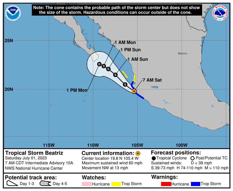
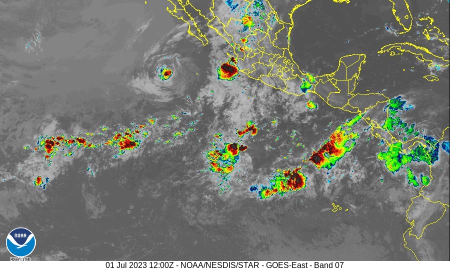
ベアトリスの中心は、1日世界標準時00UTC(日本時間午前9時)にメキシコのプンタ・サン・テルモ付近の沿岸に到達し、その後、ハリケーンとしての構造が崩れはじめている。マイクロ波衛星画像では目が消失し、散乱計と合成開口レーダーでは循環が不明瞭になっているのが確認された。さらに、マンサニージョ周辺の地表観測でも、明瞭な循環はみられなかった。これらの観測と衛星雲パターンの減少に基づき、風の強度は55 ktに低下と推定。ハリケーンから熱帯低気圧にランクダウンとなった。

1日午前7時(UTC12:00、日本時間21時)時点で、熱帯低気圧「ベアトリス」の中心は北緯19.8度、西経105.4度にあり、時速13マイル(20キロメートル)で北西に移動中で、夜までに進行スピードが徐々に遅くなる見込み。予報では、ベアトリスの中心は朝のうちにメキシコ南西部の沿岸部付近を通過、または上陸し、その後、午後から日曜日にかけてメキシコ中西部の沿岸から遠ざかる。

最大風速は現在、時速60マイル(時速95キロメートル)で、瞬間的により強い突風を伴っている。数日のうちには勢力が弱まる見通しだ。

「ベアトリス」の北上に伴い、コリマからシナロアおよびドゥランゴにかけて、南部および西部のメキシコの一部地域では、総雨量3〜5インチ(最大8インチ)の雨が予想されており、局地的に洪水や土砂崩れが発生する可能性がある。風下の沿岸地域では浸水や高波による被害が起こる可能性も。

また海上のうねりがメキシコ南西部の沿岸にみられ、高波やリップカレントによる深刻な被害を引き起こす可能性がある。
400 AM CDT Sat Jul 01 2023
The center of Beatriz brushed the coast of Mexico near Punta San Telmo back around 0000 UTC, and since then the cyclone has steadily lost organization. Earlier microwave satellite imagery shows that the eye has disappeared, while scatterometer and synthetic aperture radar data suggest that the surface circulation has become less well defined. In addition, surface observations in and around Manzanillo have not been supportive of a well-defined circulation in the area. Based on these observations and an accompanying decrease in the satellite cloud pattern, the initial intensity is reduced to an uncertain 55 kt.
At 700 AM CDT (1200 UTC)
the center of Tropical Storm Beatriz was located near latitude 19.8 North, longitude 105.4 West. Beatriz is moving toward the northwest near 13 mph (20 km/h), and this general motion with a gradual decrease in forward speed is expected through tonight. On the forecast track, the center of Beatriz is expected to move near or over portions of the coast of southwestern Mexico through this morning. Beatriz is then expected to move away from the west-central coast of Mexico later today into Sunday. Maximum sustained winds have decreased to near 60 mph (95 km/h) with higher gusts. Continued weakening is expected during the next couple of days. Tropical-storm-force winds extend outward up to 80 miles (130 km) from the center. The estimated minimum central pressure is 1001 mb (29.56 inches).
HAZARDS AFFECTING LAND
Key messages for Beatriz can be found in the Tropical Cyclone Discussion under AWIPS header MIATCDEP2 and WMO header WTPZ42 KNHC and on the web at hurricanes.gov/text/miatcdep2.shtml WIND: Tropical storm conditions are expected within the tropical storm warning area today, and are possible within the tropical storm watch areas today or tonight. RAINFALL: Through Monday, storm total rainfall of 3 to 5 inches, with maximum amounts of 8 inches, is expected across portions of southern and western Mexico from Colima northwest to Sinaloa and Durango in association with Beatriz. This rainfall could lead to localized flash flooding and mudslides. STORM SURGE: Coastal flooding is possible in areas of onshore winds. Large, potentially damaging waves are also possible along the coast. SURF: Swells generated by Beatriz are occurring along the southwestern coast of Mexico. These swells are likely to cause life-threatening surf and rip current conditions. Please consult products from your local weather office.
コメント