・サイクロン「イルサ」は勢力を強めてカテゴリー4に
・まもなくピルバラに上陸する見込み
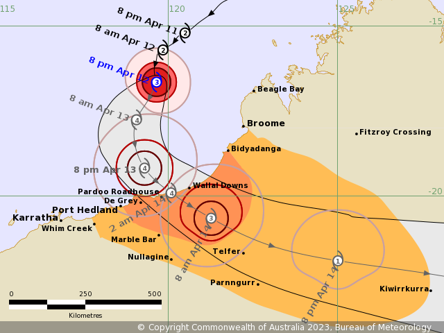
発達中のサイクロン「イルサ」は、ピルバラ海岸に向かって南に進んでいる。今後さらに勢力を強め、14日木曜日の朝にはカテゴリー4になり、東ピルバラ海岸に向けて南東に転じる予想。

ポートヘッドランドの東、ビジャダンガの西沿岸および隣接する内陸部、ウォラルダウンズ周辺では、木曜日の遅い時間帯または金曜日の早い時間帯に、大きな影響が出るおそれ。金曜日にイルサはテルファーを通過し、北部内陸を横断しながら、勢力を維持する。

■オーストラリア西部標準時、13日水曜日午後8時現在
【強さ】カテゴリー3、中心付近の風速は時速150キロメートル、瞬間的には時速205キロメートル
【位置】ブルームの北西310キロ、ポートヘッドランドの北北東425キロ
【移動】時速9キロメートルで南に進んでいる
Intensity: category 3, sustained winds near the centre of 150 kilometres per hour with wind gusts to 205 kilometres per hour.
Location: within 30 kilometres of 16.6 degrees South, 119.7 degrees East , 310 kilometres west northwest of Broome and 425 kilometres north northeast of Port Hedland .
Movement: south at 9 kilometres per hour .
Severe Tropical Cyclone Ilsa is expected to continue intensifying and move south towards the Pilbara coast. Ilsa is expected to reach Category 4 on Thursday morning and turn to the southeast towards the east Pilbara coast.
A severe impact is likely along the coast and adjacent inland parts east of Port Hedland and west of Bidyadanga, in the vicinity of Wallal Downs, late Thursday or early Friday. During Friday, Ilsa is forecast to maintain tropical cyclone intensity as it tracks past Telfer and further inland across the Northern Interior district.
コメント