・ハリケーンニコルはフロリダに上陸
・10日(木)夜はフロリダ北西部を北上
・11日(金)はサウスカロライナ州へ
・11日(金)夜までにニコルは消滅
※時間表記は現地時間
ハリケーンニコル(Nicole)は11月10日(木)現地時間午前3時に、フロリダ州の東海岸に上陸した。上陸時の最大風速は33m/s、中心気圧は981hPa。
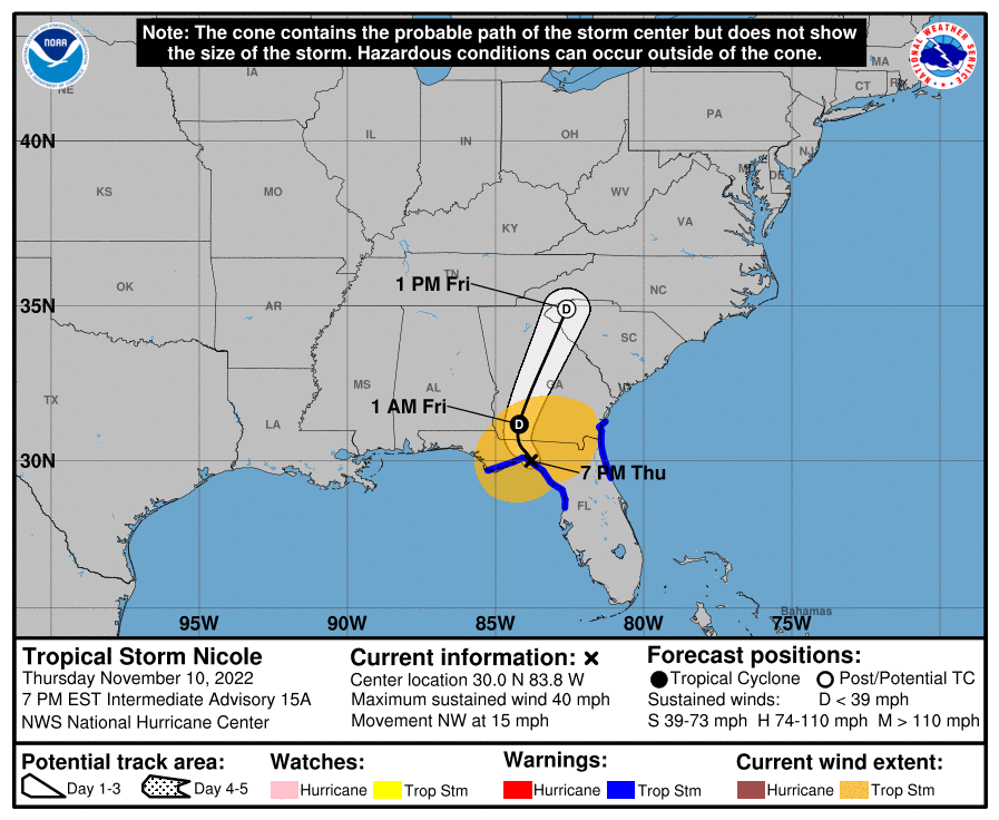
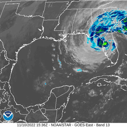
 10(木)現地時間午後7時現在、ニコルはハリケーンから熱帯低気圧に勢力を落とし、フロリダ州北西部のタラハシー市付近を時速約24キロの速さで北西に進んでいる。夜遅くに北に進路を変え、その後、金曜日にスピードを上げて北北東に進む見通し。

 10(木)夜はフロリダ北部を北上してジョージア州に入り、金曜日の後半にはジョージア州を抜けてサウスカロライナ州西部に達する。

最大風速は約18m/s(65km/h)まで弱まっているが、突風を伴っている。 強い風は主にニコル本体の南側と南西側のメキシコ湾海上で吹いている。今夜はさらに勢力を弱め、金曜日夜までにアメリカ東海岸の前線と合流する形でニコルは消滅する。

現在、強い風の範囲は、中心から最大280キロ外側に広がっていて、フロリダ州タラハシー市では、熱帯低気圧クラスの突風が観測されている。中心気圧は990hPa(29.24インチ) と推定される。
At 700 PM EST (0000 UTC), the center of Tropical Storm Nicole was located near latitude 30.0 North, longitude 83.8 West. Nicole ismoving toward the northwest near 15 mph (24km/h), and this generalmotion should continue this evening, followed by a turn toward the north later tonight. Nicole is expected to accelerate north-northeastward on Friday. On the forecast track, the center of Nicole will move over northern Florida for the next few hours and over Georgia later tonight and Friday,and into western South Carolina later on Friday,
Maximum sustained winds have decreased to near 40 mph (65 km/h) with higher gusts. These winds are mainly occurring over the Gulf of Mexico to the south and southwest of the center. Nicole is forecast to weaken to a depression tonight, and then it is expected to dissipate as it merges with a frontal boundary over the Mid-Atlantic United States by Friday night.
Tropical-storm-force winds extend outward up to 175 miles (280 km) from the center. Wind gusts to near tropical storm force have been reported in the Tallahassee, Florida area. The minimum central pressure estimated from surface observations is 990 mb (29.24 inches).

コメント