
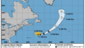
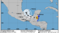
ベリーズに向かっている熱帯低気圧リサ(Lisa)がハリケーンに成長した。

11月2日現地時間午前7時、ハリケーンリサはホンジュラスの北を約15mph (24km/h) で西に進んでいる。今後2、3日は全体的に進むスピードが遅くなりそうだ。予想では、朝のうちはホンジュラスの湾岸諸島のすぐ北を移動して、今夜遅くにベリーズに上陸。その後、グアテマラ北部を横切って木曜日までにメキシコ南東部に達する見込み。

空軍のハリケーンハンター航空機からの情報では、最大風速は約75mph (34m/s) まで強まり、さらに強い突風を伴っている。リサはベリーズに接近しながら勢力を強めた後、上陸後は弱まる見込み。

強い風が吹く範囲は、中心から最大 70 マイル (110 km) 外側に広がっており、中心気圧は988hPa(29.18インチ)と推定される。
At 700 AM CDT (1200 UTC), the center of Hurricane Lisa was located near latitude 17.2 North, longitude 86.7 West. Lisa is moving toward the west near 15 mph (24 km/h). This general motion with some decrease in forward speed is forecast during the next couple of days. On the forecast track, the center of Lisa will move just north of the Bay Islands of Honduras this morning, make landfall in Belize later today, and then cross northern Guatemala and move into southeastern Mexico by Thursday.
Reports from an Air Force Hurricane Hunter aircraft indicate that the maximum sustained winds have increased to near 75 mph (120km/h) with higher gusts. Additional strengthening is forecast asLisa approaches Belize. Weakening is expected after the center makes landfall.
Tropical-storm-force winds extend outward up to 70 miles (110 km) from the center.
The minimum central pressure estimated from Air Force Hurricane Hunter aircraft observations is 988 mb (29.18 inches).
コメント