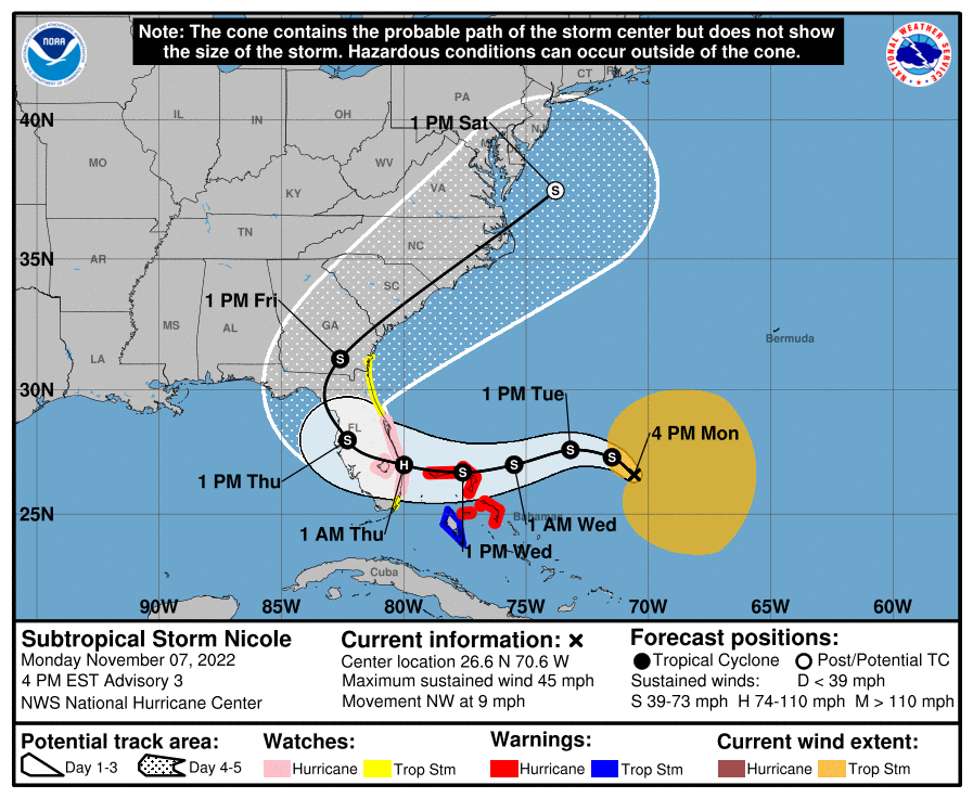
11月7日(月)現地時間午後4時。亜熱帯低気圧ニコル(nicole)はバハマ諸島の北東にあって、時速約15キロで北西に進んでいる。

日本では聞きなれない亜熱帯低気圧とは、温帯低気圧と熱帯低気圧の両方の性質を有する低気圧で、前線を伴わず台風のように明瞭な中心を持っている。例年ではハリケーンシーズンに1個あるいは数個発生し、シーズン初めか終わりに発生する場合が多い。発生しない年もある。

月曜日の夜は北西に進みながら動きが遅くなる。火曜日の夜までに西あるいは西南西に向きを変え、木曜日の早い時間帯まで同方向に進む見込み。

予想進路では。ニコルの中心は火曜日の日中から夜にかけてバハマの北西部に接近、水曜日にバハマ諸島の近くを通過あるいは一部を直撃し、水曜日の夜にフロリダの東海岸に達する。その時点で、ハリケーンクラスの勢力かそれに近い勢力に発達する。

現在、最大風速は約21メートル(75km/h) でより強い突風を伴っている。月曜日の夜から火曜日にかけて風が若干強まり、火曜日の夜から水曜日にかけては一気に強まる可能性がある。

風速18メートルの風が吹いている範囲が中心から500キロ外側に広がっており、空軍予備役偵察機の観測データから中心気圧は1000 ヘクトパスカル (29.53 インチ) と推定されている。
At 400 PM EST (2100 UTC), the center of Subtropical Storm Nicole was located near latitude 26.6 North, longitude 70.6 West. The storm is moving toward the northwest near 9 mph (15 km/h). A slower northwestward motion is expected tonight. A turn toward the west or west-southwest is forecast to begin by Tuesday night and that motion should continue through early Thursday. On the forecast track, thecenter of Nicole will approach the northwestern Bahamas on Tuesday and Tuesday night, move near or over those islands on Wednesday, and approach the east coast of Florida Wednesday night.
Maximum sustained winds are near 45 mph (75 km/h) with higher gusts.
Some slight strengthening is forecast tonight or Tuesday, with a faster rate of strengthening expected Tuesday night and Wednesday.
Nicole is forecast to be at or near hurricane intensity by Wednesday or Wednesday night while it is moving near or over the northwestern Bahamas.
Winds of 40 mph extend outward up to 310 miles (500 km) from the center. The latest minimum central pressure estimated from data from an Air Force Reserve reconnaissance aircraft is 1000 mb (29.53 inches).
コメント