
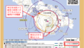
・台風3号は南大東島の南を北上中
・今後、勢力を弱めながら北東に進む
・14(水)は日本の東で温帯低気圧に

11日日曜日午前9時現在、強い勢力の台風3号は南大東島から約320キロ南の海上を北北東に進んでいる。時速は約25キロ。南大東島が風速15メートル以上の強風域に入っている。
台風は今後、勢力を弱めながら北東に進み、14日水曜日に日本のはるか東で温帯低気圧に変わる見込み。
西日本と東日本から遠く離れたエリアを進むが、台風から供給される湿った空気が梅雨前線を刺激して、12日月曜日にかけて太平洋側の地域では大雨になる恐れがある。

予想1時間雨量(12日月曜日まで・最大)
東海地方40ミリ
九州南部20ミリ
奄美地方30ミリ
As of 9:00 AM on Sunday the 11th, Typhoon No. 3, a powerful typhoon, is currently moving north-northeast over the sea approximately 320 kilometers south of Minamidaito Island. It is moving at a speed of about 25 kilometers per hour. Minamidaito Island is within the area experiencing strong winds with speeds exceeding 15 meters per second.
The typhoon is expected to continue weakening as it moves northeast, and it is anticipated to transform into an extratropical low-pressure system on Wednesday the 14th, far east of Japan.
Although it will traverse areas far away from western and eastern Japan, the moist air supplied by the typhoon may interact with the seasonal rain front and result in heavy rainfall along the Pacific side regions on Monday the 12th.

コメント