
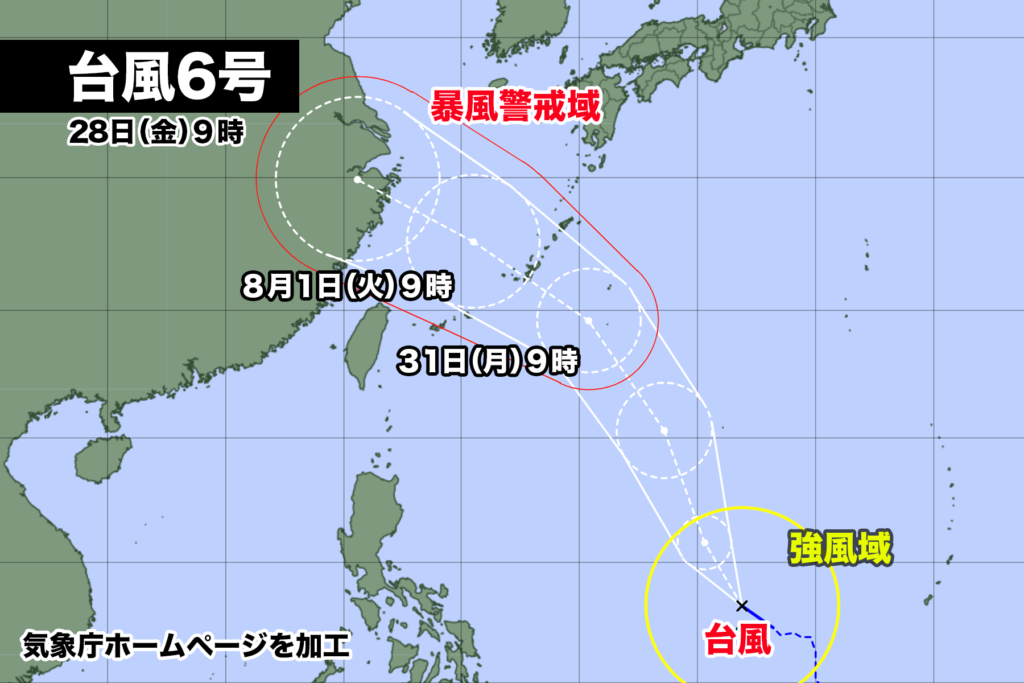
28日午前3時、フィリピンの東の海上にあった熱帯低気圧が台風6号になった。
午後9時現在中心気圧は1000hPa、中心付近の最大風速は18m/s、最大瞬間風速は25m/s。時速15km/hで西北西に進んでいる。
予報円の中心を結ぶルートを進むと、31日月曜日の夜に沖縄本島を直撃、その後、東シナ海を北西に進み、2日水曜日に上海付近に達する。
台風の接近で沖縄・奄美は海は大しけや大荒れ、大雨や高波のおそれがある。空や海の交通にも影響が出そうだ。

28日午前9時現在、沖縄と奄美地方南部が風速25m/s以上の暴風域に入る確率は最大70%。この後、さらに確率は高まる可能性がある。
At 3 a.m. on the 28th, the tropical depression over the eastern waters of the Philippines developed into Typhoon No. 6.
As of 9 p.m., the central atmospheric pressure is 1000 hPa, with maximum sustained winds near the center at 18 m/s and maximum gusts reaching 25 m/s. It is moving northwestward at a speed of 15 km/h.
If it follows the track connecting the center of the forecasted circle, Typhoon No. 6 is predicted to make a direct hit on Okinawa Main Island on Monday night, the 31st. Subsequently, it will move northwestward over the East China Sea and approach the vicinity of Shanghai on Wednesday, the 2nd.
As the typhoon approaches, Okinawa and Amami are likely to experience rough seas, stormy weather, heavy rain, and high waves. There may also be potential impacts on air and sea transportation.
As of 9 a.m. on the 28th, there is a maximum of 70% probability that Okinawa and the southern regions of Amami will enter the area of destructive winds with wind speeds of 25 m/s or higher. The probability is likely to increase even further as time progresses.

コメント