・島根県に非常に発達した雨雲が接近中
・土砂災害警情報、大雨・洪水警報発表
・中国地方は10日(月)にかけ大雨続く
・西日本〜北日本の広い範囲も梅雨空に
・来週にかけ九州北部では記録的な大雨の恐れ
・梅雨末期の大雨に要警戒
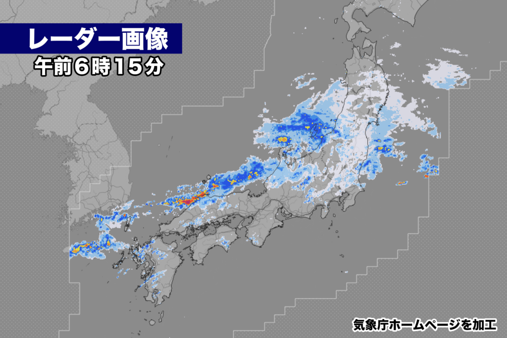
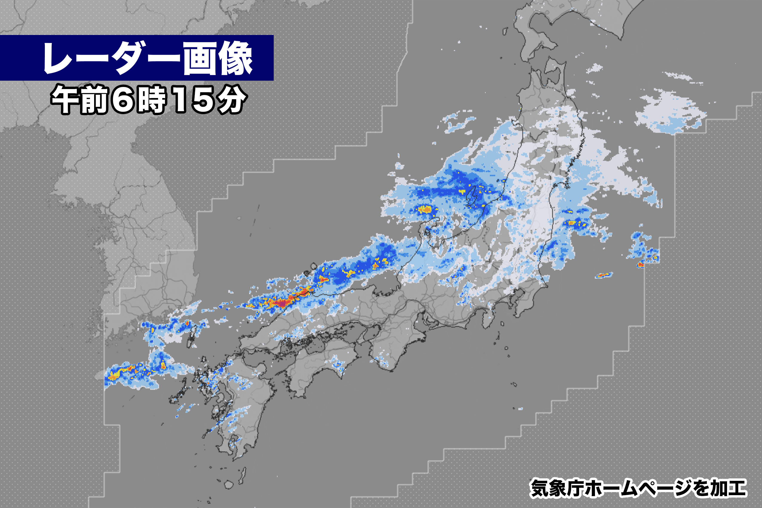
◾️8日(土)午前6時
現在、朝鮮半島から東日本にかかる梅雨前線に向かって湿った空気が流れ込み、日本海側の広い範囲で雨が降っている。特に島根県では大気の状態が非常に不安定になっていて、発達した雨雲が接近中だ。午前6時現在、松江地区と隠岐に大雨警報、出雲地区に大雨警報、洪水警報、土砂災害警戒情報が出ている。
きのう正午の降り始めからきょう5時までの総雨量は、
海士 111.0ミリ
隠岐の島町西郷  98.5ミリ
隠岐空港  97.0ミリ

中国地方では断続的な激しい雨や長雨により、10日(月)にかけて大雨が続く見込み。
そのほか西日本から北日本の広い範囲で来週前半まで雨が降り続き、九州北部地方では11日(火)までに最大550ミリの雨量が予想されている。記録的な大雨になる可能性があり、土砂災害には厳重な警戒が必要だ。

【2023年07月08日05時00分 気象庁発表】
梅雨前線が10日にかけて、本州付近に停滞するため、西日本から北日本にかけての広い範囲で大雨となる見込みです。これまでの大雨により地盤の緩んでいる所があります。土砂災害に厳重に警戒し、低い土地の浸水、河川の増水や氾濫に警戒してください。また、西日本から東日本では、大気の状態が非常に不安定となるため、落雷や竜巻などの激しい突風に注意してください。

[気圧配置など]
 梅雨前線が華中から日本海を通り、東日本から日本の東にのびています。前線は、8日夜には東日本から北日本に北上し、10日にかけて本州付近に停滞する見込みです。前線に向かって、暖かく湿った空気が流れ込んでいるため、前線の活動が活発となるでしょう。

[防災事項]
 西日本から北日本では、10日にかけて雷を伴った非常に激しい雨や激しい雨が降り、大雨となる見込みです。西日本では、これまでの大雨により地盤が緩んでおり、土砂災害の危険度が高まっている所があります。
 9日6時までの24時間に予想される雨量は、多い所で、
  九州北部地方     250ミリ
  東海地方、中国地方  180ミリ
  関東甲信地方、北陸地方  150ミリ
  東北地方       120ミリ
 10日6時までの24時間に予想される雨量は、多い所で、
  九州北部地方   100から200ミリ
  東北地方、関東甲信地方、東海地方、北陸地方、
  近畿地方、中国地方、50から100ミリ
 11日6時までの24時間に予想される雨量は、多い所で、
  九州北部地方    50から100ミリ
の見込みです。
 10日にかけて土砂災害に厳重に警戒し、低い土地の浸水、河川の増水や氾濫に警戒してください。また、落雷や竜巻などの激しい突風にも注意してください。発達した積乱雲の近づく兆しがある場合には、建物内に移動するなど、安全確保に努めてください。
Currently, moist air is flowing towards the front extending from the Korean Peninsula to eastern Japan, causing widespread rainfall in the Japan Sea side. Particularly in Shimane Prefecture, the atmospheric conditions have become extremely unstable, and well-developed rain clouds are approaching. As of 6:00 AM, heavy rain warnings have been issued for Matsue and Oki areas, and heavy rain warnings, flood warnings, and landslide warnings have been issued for Izumo area.
The total rainfall from yesterday noon to 5:00 AM today is as follows:
- Ama: 111.0 mm
- Saigo, Oki Islands: 98.5 mm
- Oki Airport: 97.0 mm
In the Chugoku region, intermittent heavy rains and prolonged rain are expected to continue until the 10th (Monday). Additionally, rain is expected to continue in a wide range from western to northern Japan until the first half of next week, with maximum rainfall of 550 mm expected in the northern part of Kyushu by the 11th (Tuesday). There is a possibility of record-breaking heavy rain, and strict caution is required against potential landslides.
——Announcement by the Japan Meteorological Agency on July 8, 2023, 5:00 AM.
The front is expected to stall near the main island of Japan around the 10th, resulting in heavy rainfall in a wide range from western to northern Japan. Some areas have already experienced loose ground due to previous heavy rainfall. Please exercise strict caution against landslides and be aware of low-lying areas prone to flooding and the rise of rivers and their potential overflow. Furthermore, in western to eastern Japan, the atmospheric conditions are expected to become highly unstable, so please be cautious of intense gusts such as lightning and tornadoes.
[Pressure Patterns, etc.] The front extends from central China through the Japan Sea and reaches the east of Japan. The front is expected to move northward from eastern Japan to northern Japan on the night of the 8th and then stall near the main island of Japan until around the 10th. Due to the influx of warm and moist air toward the front, the front is expected to become active.
[Disaster Prevention Precautions] In a wide range from western to northern Japan, heavy rain, including extremely heavy rain accompanied by thunderstorms, is expected until the 10th. Areas in western Japan have experienced loose ground due to previous heavy rainfall, increasing the risk of landslides. The predicted rainfall in the 24-hour period until 6:00 AM on the 9th is as follows:
- Northern Kyushu: 250 mm
- Tokai Region, Chugoku Region: 180 mm
- Kanto-Koshinetsu Region, Hokuriku Region: 150 mm
- Tohoku Region: 120 mm
The predicted rainfall in the 24-hour period until 6:00 AM on the 10th is as follows:
- Northern Kyushu: 100-200 mm
- Tohoku Region, Kanto-Koshinetsu Region, Tokai Region, Hokuriku Region, Kinki Region, Chugoku Region: 50-100 mm
The predicted rainfall in the 24-hour period until 6:00 AM on the 11th is as follows:
- Northern Kyushu: 50-100 mm
Please exercise strict caution against landslides until the 10th, and be aware of low-lying areas prone to flooding and the rise of rivers and their potential overflow. Additionally, please pay attention to lightning and intense gusts such as tornadoes. If there are signs of developing cumulonimbus clouds, seek shelter in sturdy buildings to ensure safety.
コメント