熱帯低気圧だったオーリーンがハリケーンになりました!
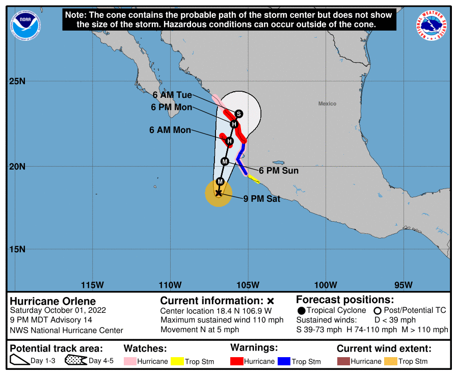
10月2日米国山岳部標準時(MDT)午後9時 (世界標準時12時) 現在、オーリーンの中心は、北緯 18.4度、西経106.9度付近にあって、時速約5マイル (7km/h)とゆっくりしたスピードで北に向かって移動していました。日曜日と月曜日には進路を北北東に変えて進行スピードが少し早まりそう。
予想進路をみると、オーリーンの中心は日曜の夜または月曜の朝にマリアス諸島付近かちょうど島の真上を通過して、月曜日の後半または夜遅くに警戒区域になっているメキシコ沿岸に達する見込み。
最大風速は約110mph (175km/h) まで強まっていて、瞬間的にはそれを上回る強さの突風が吹いています。 日曜日の早い段階までは風以外の現象も強まりそう。その後、日曜日の後半からメキシコに上陸するまでの間、勢力は次第に弱まる方向に。
オーリーンは比較的コンパクトなハリケーン。 ハリケーン級の暴風域は中心から最大10マイル (20km) 外側まで、熱帯低気圧級の暴風は最大60マイル(95km)まで広がっています。中心気圧は 966mb(28.53インチ)。
At 900 PM MDT (0300 UTC), the center of Hurricane Orlene was located near latitude 18.4 North, longitude 106.9 West. Orlene is moving toward the north near 5 mph (7 km/h). A turn toward the north-northeast with a slight increase in forward speed is expected on Sunday and Monday.
On the forecast track, the center of Orlene should pass near or over Las Islas Marias Sunday night or Monday morning and reach the coast of mainland Mexico within the warning area later on Monday or Monday night.
Maximum sustained winds have increased to near 110 mph (175 km/h) with higher gusts. Some additional strengthening is forecast through early Sunday, followed by weakening beginning later on Sunday and continuing until landfall.
Orlene is a small tropical cyclone. Hurricane-force winds extend outward up to 10 miles (20 km) from the center and tropical-storm-force winds extend outward up to 60 miles (95 km). The estimated minimum central pressure is 966 mb (28.53 inches).
コメント