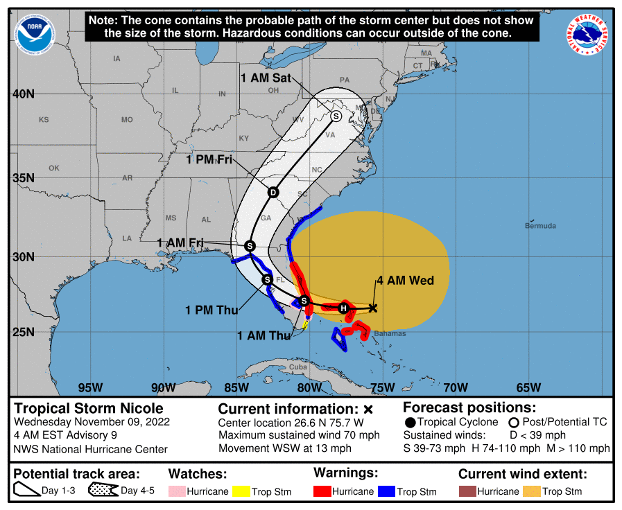
11月9日(水)現地時間午前7時、熱帯低気圧ニコル(Nicole)はバハマ諸島の北を1時間に約20キロ(13マイル)の速さで西南西に進んでいる。このあと西に進路をとり、あす木曜日は北西、金曜日は北また北北東に進む。

けさの段階でバハマ北西部に接近し、正午までにバハマの島々にかなり接近または直撃。今夜はハリケーン警報が出ているフロリダ東海岸に達する。その後、あす木曜日の日中から夜にかけてフロリダ州中部と北部を横断してジョージア南部に移動。金曜日の日中から夜にかけてカロライナ州を横断する。

最大風速は約31メートル(時速110km) で、より強い突風を伴っている。
これから若干勢力を強め、バハマ北西部近くでハリケーンになる見込み。ハリケーンの勢力を維持したまま今夜フロリダの東海岸に達し、木曜日から金曜日にかけてフロリダとアメリカ南東部を移動しながら勢力を弱める。その後、金曜日の夜までにアメリカ東部で温帯低気圧かレムナント(熱帯低気圧の残骸)に変わる。

ニコルは大型の熱帯低気圧で、強風の範囲は中心から60マイル(740キロ) 外側まで広がっており特に北側で風が強く吹いている。ここ数時間で、フロリダ州レイクワースピアにあるアメリカ国立海洋局の観測所で、20m/s(71km/h) の風と25m/s(89km/h) の突風が観測された。

NOAAアメリカ海洋大気庁のハリケーンハンター航空機によるデータでは、中心気圧は986ヘクトパスカル(29.12インチ) 。
At 700 AM EST (1200 UTC), the center of Tropical Storm Nicole was located near latitude 26.6 North, longitude 76.2 West. Nicole is moving toward the west-southwest near 13 mph (20 km/h). A turn toward the west is expected today, followed by a turn toward the northwest on Thursday, and north or north-northeast on Friday. On the forecast track, the center of Nicole will approach the northwestern Bahamas this morning, move near or over those islands by midday, and approach the east coast of Florida within the hurricane warning area tonight. Nicole’s center is then expected to move across central and northern Florida into southern Georgia Thursday and Thursday night, and then across the Carolinas Friday and Friday night.
Maximum sustained winds are near 70 mph (110 km/h) with higher gusts. Some strengthening is expected today, and Nicole is forecast to become a hurricane near the northwestern Bahamas and remain a hurricane when it reaches the east coast of Florida tonight. Nicole is expected to weaken while moving across Florida and the southeastern United States Thursday through Friday, and it is likely to become a post-tropical cyclone by Friday night over the Mid-Atlantic states.
Nicole is a large tropical storm. Tropical-storm-force winds extend outward up to 460 miles (740 km) especially to the north of the center. During the past few hours, a National Ocean Service station at the Lake Worth Pier, Florida, reported sustained winds of 44 mph (71 km/h) and a wind gust of 55 mph (89 km/h).
The minimum central pressure reported by a NOAA Hurricane Hunter aircraft is 986 mb (29.12 inches).
コメント