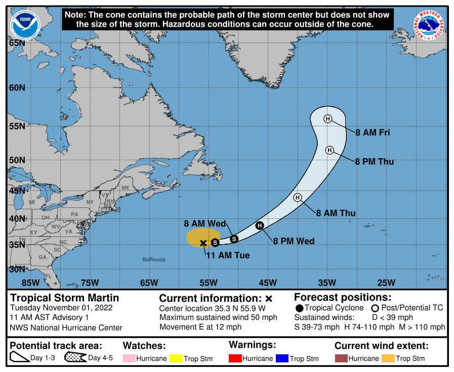
11月1日現地時間午前11時、熱帯低気圧マーティン(Martin) はバミューダ諸島の北東にあり、時速約12マイル(19キロ)で東に移動している。 風の強い範囲は中心から205マイル(335キロ)に広がっていて、中心気圧は997ヘクトパスカル。今後2日間のうちに北東に向きを変え、より速いスピードで進む見込み。

最大風速は約50mph (85km/h、23m/s) で、強い突風を伴っている。今後48 時間の間に若干勢力を強め、水曜日の夜までにハリケーンに発達、木曜日には勢力の強い温帯低気圧に変わる予想だ。
At 1100 AM AST (1500 UTC), the center of Tropical Storm Martin was located near latitude 35.3 North, longitude 55.9 West. Martin is moving toward the east near 12 mph (19 km/h). The tropical storm is anticipated to turn toward the northeast at a faster rate of forward speed during the next two days. Maximum sustained winds are near 50 mph (85 km/h) with higher gusts. Some strengthening is forecast during the next 48 hours, and Martin is expected to become a hurricane by Wednesday night before transitioning to a powerful extratropical system on Thursday. Tropical-storm-force winds extend outward up to 205 miles (335 km) from the center. The estimated minimum central pressure is 997 mb (29.44 inches).
コメント