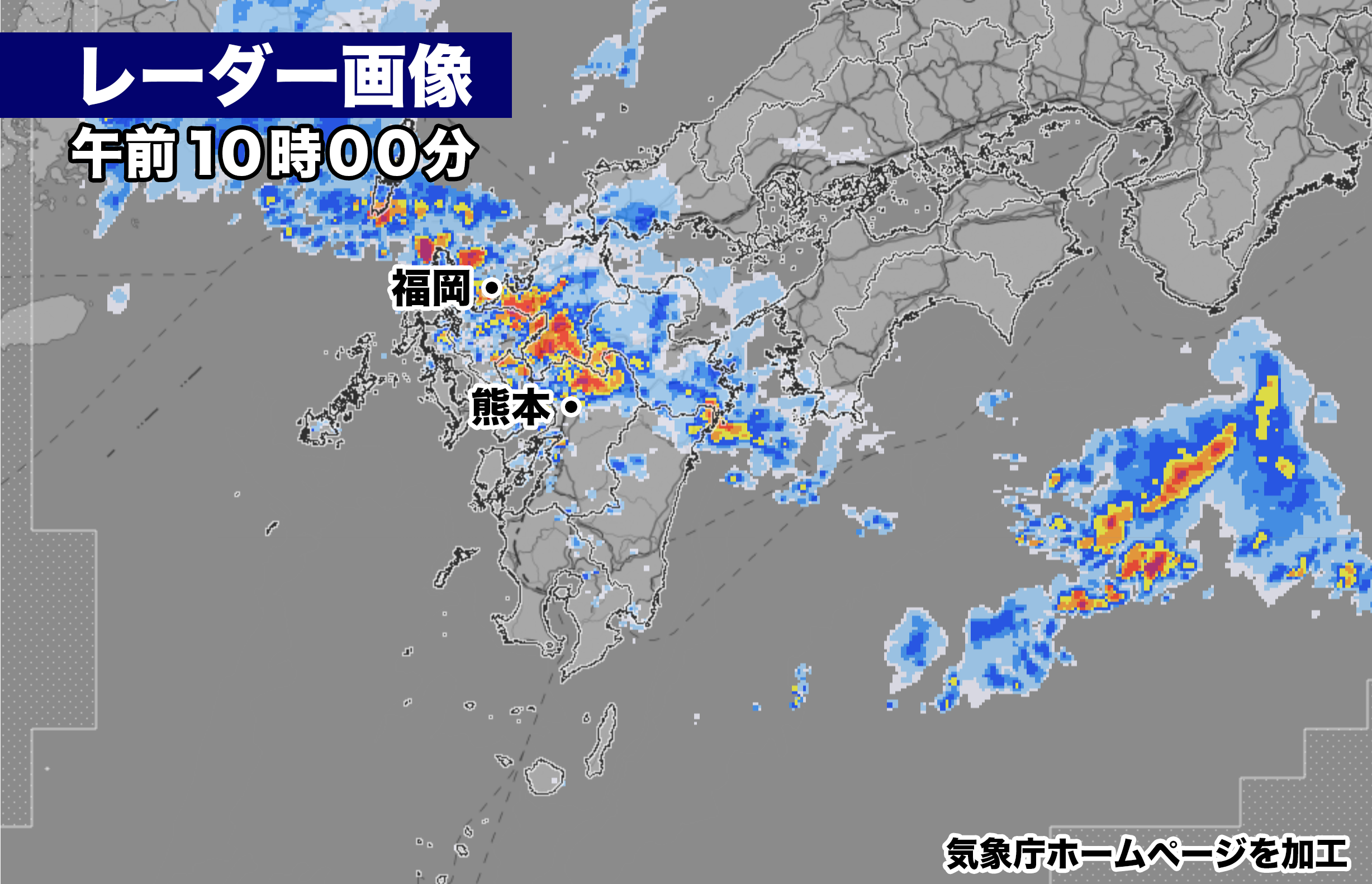
・九州北部地方で所により1時間に30ミリを超える強い雨
・今夜には中国・四国地方、近畿地方も雨が降り出す
・梅雨線前は10日(月)にかけて九州北部地方に停滞
・断続的に激しい雨、一部で非常に激しい雨
・雨量がまとまり土砂災害の危険度が高まるおそれ

梅雨前線に伴う発達した雨雲が福岡県、熊本県、大分県を通過中。
所によって1時間に30ミリを超える激しい雨が降っている。雨雲はこのあと次第に東に広がり、今夜には中国・四国地方、近畿地方も雨が降り出す見込み。梅雨前線は10日(月)頃まで九州北部地方に停滞し、断続的に雷を伴い激しい雨が降るおそれがある。降り始めからの総雨量が最大600ミリを超える可能性があり、土砂災害に厳重な警戒が必要だ。

【2023年07月07日05時30分 福岡管区気象台発表】
10日頃にかけて梅雨前線が九州北部地方に停滞し、活動が活発となるため、大雨となるおそれがあります。土砂災害に厳重に警戒し、低い土地の浸水、河川の増水や氾濫に警戒してください。

 梅雨前線が華中から九州にのびています。梅雨前線は今後ゆっくり北上し、10日頃にかけて九州北部地方に停滞する見込みです。前線に向かって暖かく湿った空気が流れ込むため、前線の活動が活発となり、大気の状態が非常に不安定になるでしょう。
 このため、九州北部地方では、7日昼前から10日頃にかけて、断続的に雷を伴い激しい雨が降り、特に8日から9日は非常に激しい雨が降る所があるでしょう。これまでの大雨により地盤が緩んでいる所があり、10日頃にかけて雨が断続的に降り続くため、土砂災害の危険度が高くなる見込みです。また、落雷や竜巻などの激しい突風のおそれもあります。

<雨の予想>
7日に予想される1時間降水量は、いずれも多い所で、
 山口県 30ミリ
 福岡県 40ミリ
 佐賀県 40ミリ
 長崎県 30ミリ
 大分県 40ミリ
 熊本県 40ミリ
8日に予想される1時間降水量は、いずれも多い所で、
 山口県 60ミリ
 福岡県 60ミリ
 佐賀県 60ミリ
 長崎県 60ミリ
 大分県 60ミリ
 熊本県 50ミリ

7日6時から8日6時までに予想される24時間降水量は、いずれも多い所で、
 山口県 120ミリ
 福岡県 120ミリ
 佐賀県 120ミリ
 長崎県 120ミリ
 大分県 120ミリ
 熊本県 120ミリ

その後、8日6時から9日6時までに予想される24時間降水量は、いずれも多い所で、
 山口県 200から300ミリ
 福岡県 200から300ミリ
 佐賀県 200から300ミリ
 長崎県 200から300ミリ
 大分県 200から300ミリ
 熊本県 200から300ミリ

その後、9日6時から10日6時までに予想される24時間降水量は、いずれも多い所で、
 山口県 100から200ミリ
 福岡県 100から200ミリ
 佐賀県 100から200ミリ
 長崎県 100から200ミリ
 大分県 100から200ミリ
 熊本県 100から200ミリ

<防災事項>
 土砂災害に厳重に警戒し、低い土地の浸水、河川の増水や氾濫に警戒してください。落雷や竜巻などの激しい突風に注意してください。発達した積乱雲の近づく兆しがある場合には、建物内に移動するなど、安全確保に努めてください。
Developed rain clouds associated with the seasonal rain front are currently passing through Fukuoka, Kumamoto, and Oita Prefectures. In some areas, heavy rain exceeding 30 millimeters per hour is occurring. The rain clouds will gradually spread eastward, and rain is expected to begin in the Chugoku, Shikoku, and Kinki regions tonight. The seasonal rain front is expected to stall in northern Kyushu until around the 10th (Monday), with intermittent thunderstorms and heavy rain.There is a possibility that the total rainfall from the beginning of the rain may exceed 600 millimeters, requiring strict caution against sediment disasters.
—-Announcement from Fukuoka Regional Meteorological Observatory, issued on July 7th, 05:30
From around the 10th, the seasonal rain front is expected to stall and become more active in northern Kyushu, raising the potential for heavy rain. Please exercise extreme caution against sediment disasters and be vigilant against flooding of low-lying areas, river flooding, and overflowing.
The seasonal rain front extends from the central part of Japan to Kyushu. The front is expected to slowly move northward and stall in northern Kyushu around the 10th. As warm and humid air flows toward the front, frontal activity is expected to become more active, leading to highly unstable atmospheric conditions. Therefore, in northern Kyushu, from the morning of the 7th until around the 10th, intermittent thunderstorms and heavy rain are expected, with particularly heavy rain on the 8th and 9th. Due to previous heavy rain, there are areas where the ground has loosened, and with intermittent rain continuing until around the 10th, the risk of sediment disasters is expected to be high. There is also a risk of intense gusts such as lightning strikes and tornadoes.
[Rainfall Forecast] The expected hourly precipitation on the 7th is significant in all areas:
- Yamaguchi Prefecture: 30 mm
- Fukuoka Prefecture: 40 mm
- Saga Prefecture: 40 mm
- Nagasaki Prefecture: 30 mm
- Oita Prefecture: 40 mm
- Kumamoto Prefecture: 40 mm
The expected hourly precipitation on the 8th is significant in all areas:
- Yamaguchi Prefecture: 60 mm
- Fukuoka Prefecture: 60 mm
- Saga Prefecture: 60 mm
- Nagasaki Prefecture: 60 mm
- Oita Prefecture: 60 mm
- Kumamoto Prefecture: 50 mm
The expected 24-hour precipitation from 06:00 on the 7th to 06:00 on the 8th is significant in all areas:
- Yamaguchi Prefecture: 120 mm
- Fukuoka Prefecture: 120 mm
- Saga Prefecture: 120 mm
- Nagasaki Prefecture: 120 mm
- Oita Prefecture: 120 mm
- Kumamoto Prefecture: 120 mm
Subsequently, the expected 24-hour precipitation from 06:00 on the 8th to 06:00 on the 9th is significant in all areas:
- Yamaguchi Prefecture: 200 to 300 mm
- Fukuoka Prefecture: 200 to 300 mm
- Saga Prefecture: 200 to 300 mm
- Nagasaki Prefecture: 200 to 300 mm
- Oita Prefecture: 200 to 300 mm
- Kumamoto Prefecture: 200 to 300 mm
The expected 24-hour precipitation from 06:00 on the 9th to 06:00 on the 10th is significant in all areas:
- Yamaguchi Prefecture: 100 to 200 mm
- Fukuoka Prefecture: 100 to 200 mm
- Saga Prefecture: 100 to 200 mm
- Nagasaki Prefecture: 100 to 200 mm
- Oita Prefecture: 100 to 200 mm
- Kumamoto Prefecture: 100 to 200 mm
[Disaster Prevention Information] Exercise extreme caution against sediment disasters, and be vigilant against flooding of low-lying areas, river flooding, and overflowing. Pay attention to intense gusts such as lightning strikes and tornadoes. If there are signs of approaching developed cumulonimbus clouds, take measures to ensure safety, such as moving indoors to sturdy buildings.

コメント