

【12日土曜日 午前9時現在】
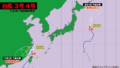
小笠原諸島にある熱帯低気圧が24時間以内に台風5号になる見込みです。その後、台風はやや発達しながら北に進み、14日月曜日に関東地方に接近または上陸する恐れがあります。
14日月曜日の日中から夜にかけて東北地方を縦断、15日火曜日の朝に北海道で温帯低気圧に変わります。
風速25メートル以上の暴風域は発生しない見込みですが、関東に接近する時は20メートルを超える最大風速が予想されています。公共交通機関の乱れや停電、大雨に警戒が必要です。

[As of 9:00 a.m. Saturday, the 12th]
A tropical depression located near the Ogasawara Islands is expected to develop into Typhoon No. 5 within the next 24 hours. The system is forecast to gradually strengthen as it moves northward, potentially approaching or making landfall in the Kanto region on Monday, the 14th.
Afterward, the typhoon is expected to track northeast across the Tohoku region from Monday daytime through the night, and transition into an extratropical cyclone over Hokkaido by the morning of Tuesday, the 15th.
While the system is not expected to generate a storm-force wind area with sustained winds over 25 meters per second, peak wind speeds exceeding 20 meters per second are forecast as it nears the Kanto region. Caution is advised for possible disruptions to public transportation, power outages, and heavy rainfall.

コメント