

【2025年7月13日(日)午前9時45分】
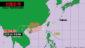
小笠原諸島にあった熱帯低気圧が、きょう午前3時に台風5号になりました。現在は少しずつ発達をしながら北上を続けています。
台風が予報円の中心を進んだ場合、あす月曜日に関東地方に接近、その後、東北地方の太平洋側を北上する見込みです。あさって火曜日は北海道を縦断し、16日(水)に千島列島の東で温帯低気圧に変わります。
台風の接近に伴い、関東地方はあす午前から警報級の大雨になる恐れがあり、千葉県や茨城県では波浪警報が発表される可能性があります。また福島県や宮城県など東北地方では風が次第に強まる見込みで、暴風にも警戒が必要です。

[Sunday, July 13, 2025, 9:45 AM JST]
A tropical depression located near the Ogasawara Islands developed into Typhoon No. 5 at 3:00 AM today. The typhoon is currently intensifying gradually as it continues to move northward.
If the storm follows the projected path along the center of the forecast track, it is expected to approach the Kanto region on Monday before tracking further north along the Pacific coast of the Tohoku region. On Tuesday, it is forecast to pass over Hokkaido and transition into an extratropical cyclone east of the Kuril Islands by Wednesday, July 16.
As the typhoon approaches, heavy rain reaching warning levels may begin affecting the Kanto region starting Monday morning. In Chiba and Ibaraki prefectures, high wave warnings may also be issued. In addition, strong winds are expected to gradually intensify in the Tohoku region, including Fukushima and Miyagi prefectures, where residents are advised to remain alert for possible storm-force winds.

コメント