
【7月24日(木)午前0時】
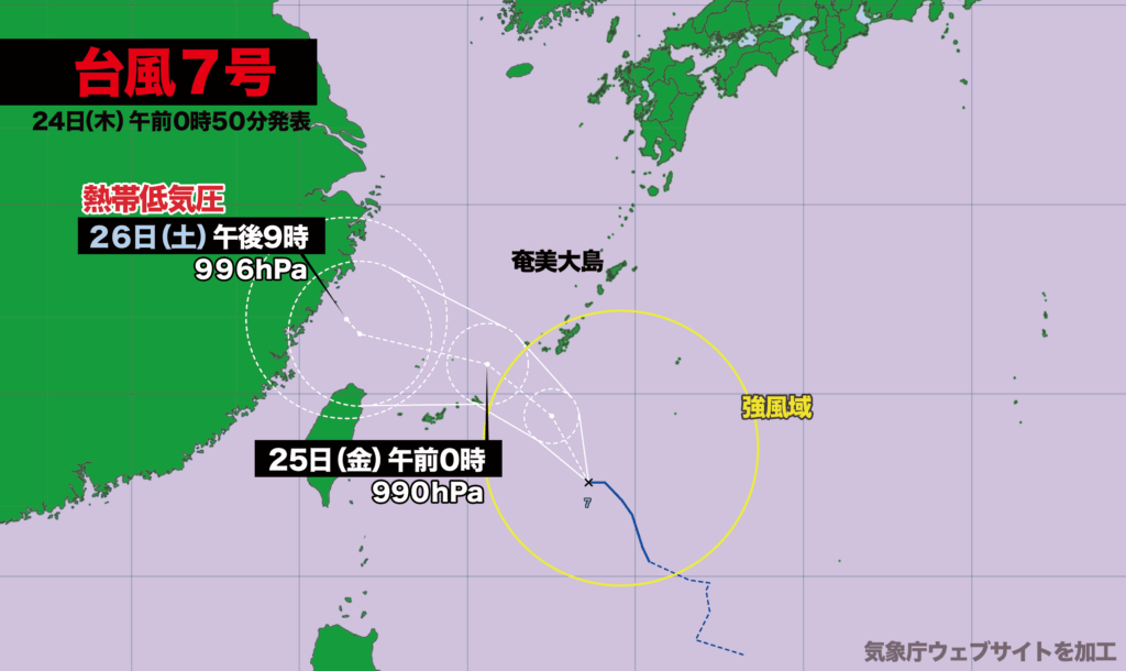
台風7号は午前0時現在、沖縄の南を時速約20キロで西北西に進んでいます。中心気圧は994ヘクトパスカル、最大瞬間風速は30メートルです。
沖縄本島と奄美地方南部が風速15メートル以上の強風域に入っていて、このあと台風はやや発達しながら北西方向に進む見込みです。
台風が予報円の中心を進んだ場合、25日(金)に東シナ海に進み、26日(土)に中国大陸沿岸で熱帯低気圧になると予想されています。
台風の接近に伴い、沖縄・奄美では25日(金)にかけて、海上はうねりを伴ってしけ模様となり、局地的に非常に激しい雨が降る恐れがあります。波浪警報や大雨警報が発表される可能性があり、高波、土砂災害、低い土地の浸水、川の急激な増水や氾濫に警戒が必要です。
Typhoon No. 7 Approaching Okinawa and Amami with Strong Winds and Heavy Rainfall Expected
[Thursday, July 24 – 12:00 a.m.]
As of midnight on July 24, Typhoon No. 7 is moving west-northwest at approximately 20 kilometers per hour, situated to the south of Okinawa. The central pressure is recorded at 994 hectopascals, with maximum instantaneous wind speeds reaching 30 meters per second.
Strong winds of 15 meters per second or more are currently affecting Okinawa’s main island and the southern part of the Amami region. The typhoon is forecast to gradually intensify as it continues its northwestward trajectory.
If the typhoon proceeds along the center of its projected path, it is expected to enter the East China Sea on Friday, July 25, and weaken into a tropical depression near the Chinese mainland coast by Saturday, July 26.
Due to the typhoon’s approach, sea conditions around Okinawa and Amami are expected to become rough with accompanying swells through Friday. There is also a risk of localized torrential rainfall. Authorities warn of the potential issuance of high wave and heavy rain advisories. Residents are urged to stay alert for high surf, landslides, flooding in low-lying areas, and sudden river rises or overflows.
コメント