
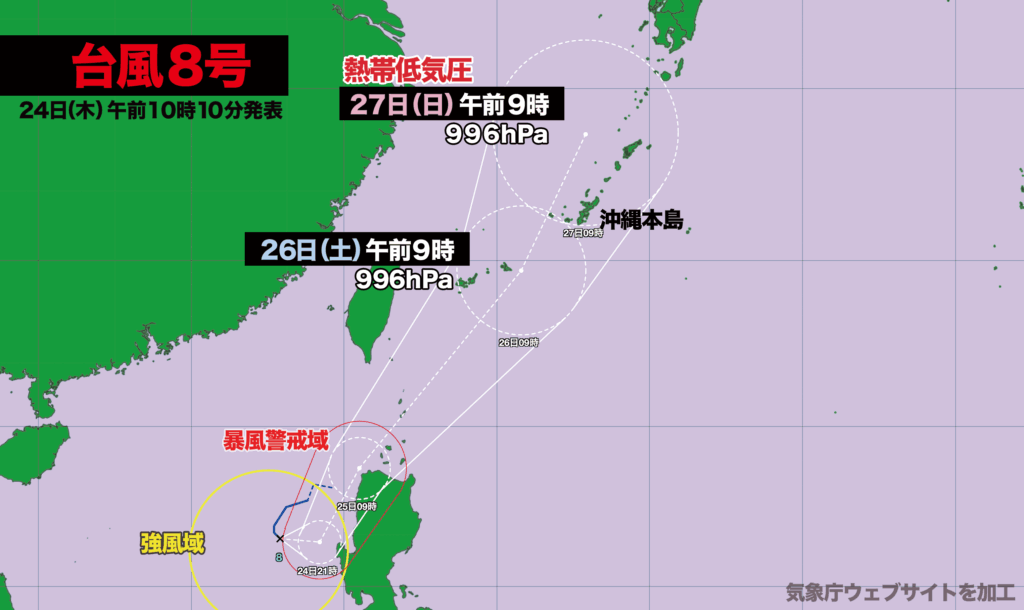
【7月24日(木)午前9時】
昨夜午後9時に南シナ海で台風8号が発生しました。現在はフィリピンの西を時速15キロで南南東に進んでいます。中心気圧は985ヘクトパスカル、最大瞬間風速は35メートルです。
今夜には風速25メートル以上の暴風域が発生して、進路を北に変える見込みです。その後は北上を続け、26日(土)午前9時に沖縄の宮古島に最接近、27日(日)午前9時に鹿児島県の奄美大島の西で熱帯低気圧に変わる予想となっています。
沖縄・奄美は台風7号に続いて、8号の影響も受ける見込みで、きょうから日曜日にかけて、大雨、強風、高波による災害が発生する恐れがあります。土砂災害、低い土地の浸水、川の急激な増水や氾濫、落雷、竜巻などの激しい突風に警戒が必要です。

Typhoon No. 8 Forms in South China Sea, Expected to Approach Okinawa and Amami After Typhoon No. 7
[Thursday, July 24 – 9:00 a.m.]
Typhoon No. 8 formed over the South China Sea at 9:00 p.m. last night. As of this morning, it is moving south-southeast at a speed of 15 kilometers per hour, located west of the Philippines. The storm currently has a central pressure of 985 hectopascals, with maximum instantaneous wind speeds reaching 35 meters per second.
Violent winds exceeding 25 meters per second are expected to develop by tonight, as the typhoon begins to shift its course northward. It is forecast to continue moving north, drawing closest to Miyako Island in Okinawa at 9:00 a.m. on Saturday, July 26. By 9:00 a.m. on Sunday, July 27, it is expected to weaken into a tropical depression to the west of Amami Ōshima in Kagoshima Prefecture.
Following the impact of Typhoon No. 7, Okinawa and Amami are now bracing for further effects from Typhoon No. 8. From today through Sunday, there is an increased risk of disasters caused by heavy rainfall, strong winds, and high waves. Residents are urged to remain vigilant for potential landslides, flooding in low-lying areas, rapid rises in river levels and overflows, as well as dangerous weather phenomena such as lightning and tornado-like gusts.

コメント