
【28日(月)午前0時】
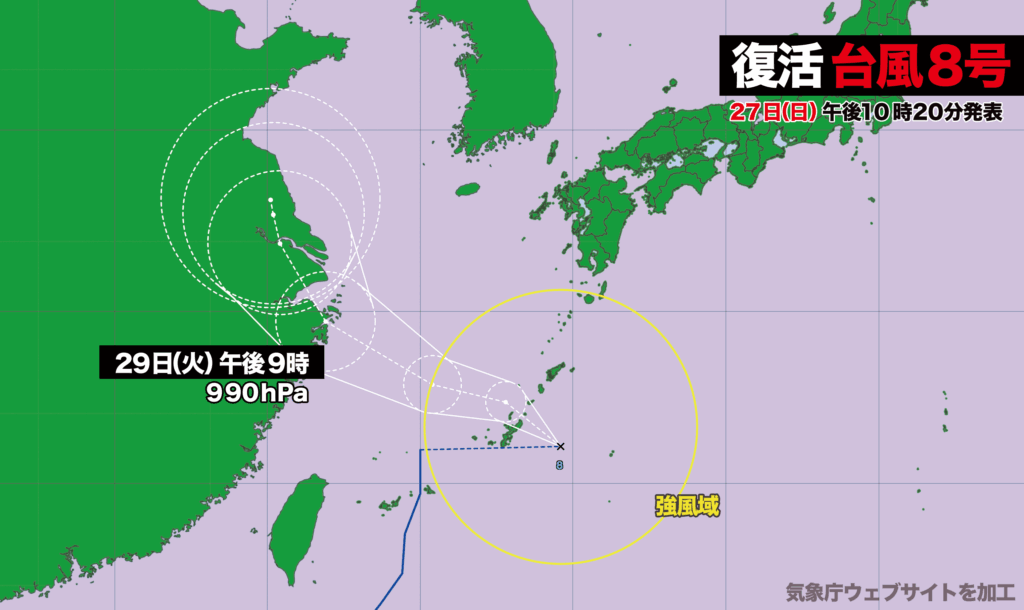
26日(土)午前9時に東シナ海で熱帯低気圧に変わった台風8号が、27日(日)午後9時に再び台風に発達しました。
現在、台風の中心は沖縄本島の東にあってほとんど停滞しています。中心気圧は992ヘクトパスカル、最大瞬間風速は25メートル。台風の復活に伴い、沖縄と奄美、鹿児島県の十島村と種子島・屋久島が風速15メートル以上の強風域に巻き込まれています。
台風はこの後、奄美地方南部付近を通過し、東シナ海を西に進む見込みで、29日(火)に上海付近に達する予想です。
奄美地方では、28日(月)はうねりを伴った高波に警戒し、奄美地方と沖縄地方では、土砂災害、低い土地の浸水、河川の増水に注意・警戒が必要です。
また、沖縄地方では28日(月)明け方にかけて、線状降水帯が発生して大雨災害発生の危険度が急激に高まる可能性があります。
なお、熱帯低気圧に変わった台風が再発達して復活するのは、2018年の台風28号以来、7年ぶりのことです。

Typhoon Reforms in East China Sea, Brings Strong Winds and Heavy Rain to Okinawa and Amami
[00:00, Monday, 28th]
Typhoon No. 8, which had downgraded to a tropical depression over the East China Sea at 9 a.m. on Saturday, July 26, re-strengthened into a typhoon at 9 p.m. on Sunday, July 27.
As of early Monday, the typhoon’s center remains almost stationary to the east of Okinawa’s main island. The central pressure is 992 hPa, and the maximum instantaneous wind speed is 25 meters per second. With the typhoon’s re-intensification, areas experiencing sustained winds of 15 meters per second or more now include Okinawa, Amami, Toshima Village and the Tanegashima–Yakushima region of Kagoshima Prefecture.
The typhoon is forecast to pass near the southern part of the Amami region and move westward across the East China Sea, potentially reaching the vicinity of Shanghai on Tuesday, July 29.
In the Amami region, residents are urged to be on alert for high waves accompanied by swells on Monday, July 28. Both the Amami and Okinawa regions should remain vigilant for the risks of landslides, flooding in low-lying areas, and rising river levels.
Additionally, in the Okinawa region, there is a heightened risk that a linear rainband could develop through early Monday morning, significantly increasing the potential for severe rainfall-related disasters.
This marks the first time in seven years that a typhoon has redeveloped after weakening into a tropical depression — the last occurrence being Typhoon No. 28 in 2018.

コメント