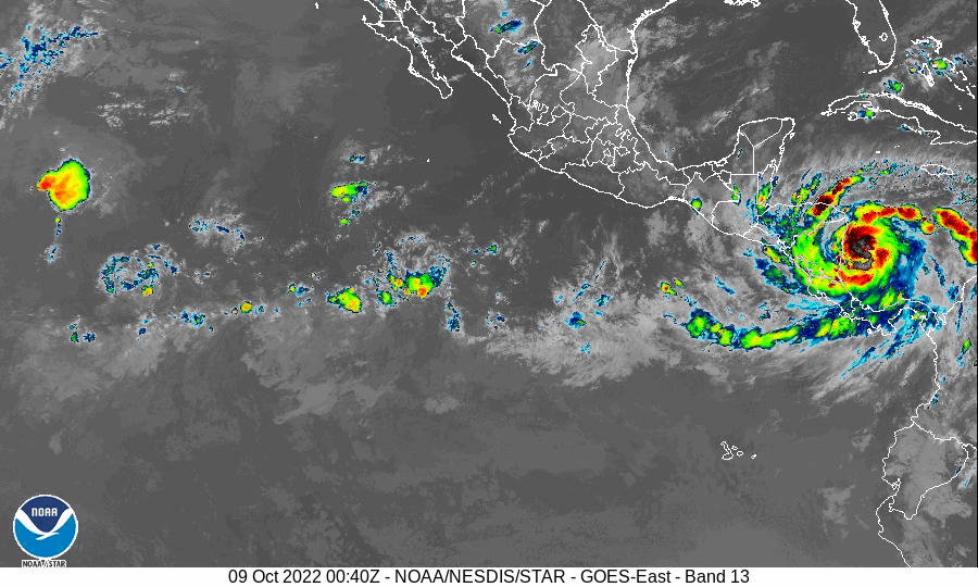

衛星画像とニカラグアのレーダー観測の結果、ハリケーン・ジュリアの中心は、きょう10月9日(日曜日)、現地時間午前3時15分に、ニカラグアのラグナ・デ・ペルラス近くの海岸に上陸。上陸時の最大風速は推定で39m/s。現在は熱帯低気圧にランクダウンしている。
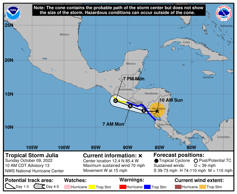
きょう午前10時(世界標準時15時)には、熱帯低気圧ジュリアは北緯12.4度、西経85.4度の内陸にあり、時速約24キロで西に向かって移動していた。きょうはこうした動きが続くが、今夜から月曜日にかけてわずかにスピードを緩めて西北西に進路を変える。
予想進路は、きょうはニカラグアを移動、夜までに太平洋側に抜ける見通しで、月曜日はホンジュラス、エルサルバドル、グアテマラの太平洋沿岸の非常に近い所を進む。
最大風速は突風は伴うものの約30メートルまで減少、熱帯低気圧本体もここ数日でさらに衰弱が進む見込み。
今夜から月曜日にかけニカラグア、ホンジュラス、エルサルバドルの沿岸を進む際はまだ熱帯低気圧のままだが、その後、月曜日の夜までにグアテマラの海岸付近で消滅する予想。
強風域は熱帯低気圧の中心から最大150キロ外側に広がり、中心気圧は993hPaと推定される。
Satellite and Nicaraguan radar data indicate that the center of Julia has made landfall along the coast near Laguna de Perlas in Nicaragua at 315 AM EDT…0715 UTC. Maximu sustained winds at landfall were estimated to be 85 mph (140 km/h).
At 1000 AM CDT (1500 UTC), the center of Tropical Storm Julia was located inland near latitude 12.4 North, longitude 85.4 West.
Julia is moving toward the west near 15 mph (24 km/h), and this motion is expected to continue today, with a slightly slower west-northwestward motion tonight and Monday. On the forecast track, the center of Julia is expected to continue moving over Nicaragua today and emerge off the Pacific coast by this evening.
Julia is then expected to move very near to and parallel to the Pacific coasts of Honduras, El Salvador, and Guatemala tonight and Monday.
Maximum sustained winds have decreased to near 70 mph (110 km/h) with higher gusts. Additional weakening is forecast during the next day or two, but Julia is still expected to be a tropical storm when it moves near the Pacific coasts of Nicaragua, Honduras, and El Salvador tonight and Monday. Julia is expected to dissipate near the coast of Guatemala by Monday night.
Tropical-storm-force winds extend outward up to 90 miles (150 km) from the center. The estimated minimum central pressure is 993 mb (29.33 inches).

コメント