・ハリケーン「ベアトリス」が発生
・現在、メキシコ西海岸を北西に進んでいる
・メキシコ南部と南西部は大雨による土砂災害、暴風、高潮の危険度高まる
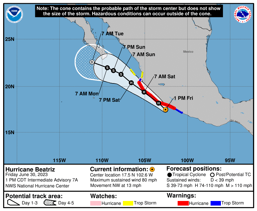
2023年6月30日金曜日、午前10時(中部夏時間)

直近のGOES(地球観測衛星)の可視および赤外線衛星画像ではハリケーンの目が確認でき、国立ハリケーンセンター(NHC)・熱低解析・予報支局(TAFB)の推定値はT値が4.0、65 kt、ウイスコンシン大学気象衛星研究協力機関(UW-CIMSS)のADT値は4.0まで上昇している。これを受け、ベアトリスは最大風速65 ktと推定されるハリケーンに格上げとなった。予報局のハリケーン予報飛行機が数時間後にベアトリスを調査する予定で、今後、推定強度の精度が上がる見込み。

ベアトリスの初期の進路は北西方向でスピードは11 ktを維持。南部アメリカとメキシコ北部上空にある中層リッジの南西部周縁に沿って移動すると予想されており、向こう48時間も北西方向に進む。ただ、熱帯低気圧がメキシコ西海岸に沿って進む場合、中心が海岸沿いを進むか、あるいはある時点で内陸に進むかについては不確定性が大きい。現在、国立ハリケーンセンターは、ベアトリスは向こう24〜36時間で海岸をかすめるように進むシナリオを描いている。一方、ヨーロッパ中気予報センター(ECMWF)やイギリス気象庁(UKMET)などのモデルでは、内陸に進んで消滅する予想が出ている。ベアトリスがこの先48時間消滅しない場合、中層リッジが南西部アメリカ上空に形成されるにつれて、進行スピードは遅くなり西北西に向きを変えると予想される。

もしベアトリスの中心が海上にとどまる場合、勢力が強まる条件が整っているため、向こう12〜24時間はハリケーンとしての勢力は維持される。一方、メキシコの急峻な地形を進んだ場合、急速に勢力が弱まるだろう。向こう36時間消滅せずにハリケーンとして存続した場合、冷たい海面温度、下降気流などの条件により、2日目と3日目は徐々に勢力は弱まる。最新の全球モデルのガイダンスでは、ベアトリスは4日目にレムナント(低気圧の残骸)に変わり、5日目には消滅する可能性が高い。

警戒情報
ベアトリスは予報どおり勢力を強め、土曜日まではハリケーンとして、メキシコ南西海岸の一部に危険な暴風と高潮のリスクをもたらす見込み。現在、ゲレーロ、ミチョアカン、コリマ、ハリスコの沿岸地域にハリケーン警報が発令されている。
メキシコ南部のオアハカ州からナヤリット州にかけては局地的な大雨が予想されていて、命にかかわるレベルの洪水や土砂崩れを引き起こす恐れがある。
Hurricane Beatriz Discussion Number   7
NWS National Hurricane Center Miami FL       EP022023
1000 AM CDT Fri Jun 30 2023

Recent GOES 1-minute visible and infrared satellite imagery show
that an eye is forming.  A special classification from TAFB yielded
an estimate of T4.0/65 kt, and raw UW-CIMSS ADT values are also up
to 4.0.  Therefore, Beatriz has been upgraded to a hurricane with
maximum winds estimated to be 65 kt.  An Air Force Reserve Hurricane
plane is scheduled to investigate the storm in a few hours,
hopefully providing a refinement in the estimated intensity.

Beatriz's initial motion remains northwestward, or 305/11 kt.  The
storm is expected to continue moving northwestward during the next
48 hours as it moves along the southwestern periphery of a
mid-level ridge located over the southern United States and
northern Mexico.  However, as is often the case with cyclones
paralleling the west coast of Mexico, there is significant
uncertainty as to whether Beatriz's center will continue to skirt
the coast or move inland at some point.  The NHC track forecast
continues to show a scenario where Beatriz grazes the coast during
the next 24-36 hours, but models such as the ECMWF and UKMET do
bring the system inland and show dissipation.  If Beatriz survives
the next 48 hours, it would then likely slow down and turn toward
the west-northwest as a mid-level ridge builds over the
southwestern U.S.

If Beatriz's center remains offshore, environmental conditions
should otherwise be conducive for additional strengthening during
the next 12-24 hours, and the storm is forecast to remain a
hurricane until after it passes Cabo Corrientes.  On the other hand,
if the center reaches land, the mountainous terrain of Mexico would
likely cause rapid weakening.  Assuming survival during the next 36
hours, increasing shear out of the east-northeast, cooler sea
surface temperatures, and a drier, more subsident environment would
likely lead to gradual weakening on days 2 and 3.  Based on the
latest global model guidance, Beatriz is likely to have degenerated
into a remnant low by day 4 and dissipate by day 5.


KEY MESSAGES:

1. Beatriz is forecast to continue strengthening and remain a
hurricane through Saturday, bringing a risk of hurricane-force
winds and a dangerous storm surge to portions of the southwestern
coast of Mexico during the next day or so.  A Hurricane Warning is
in effect for portions of the coasts of Guerrero, Michoacan, Colima,
and Jalisco, and hurricane conditions are expected somewhere in
those areas later today and on Saturday.

2. Locally heavy rainfall is expected across southern Mexico from
the state of Oaxaca westward to the state of Nayarit.  These rains
could lead to life-threatening flash flooding and mudslides.


FORECAST POSITIONS AND MAX WINDS

INIT  30/1500Z 17.3N 102.3W   65 KT  75 MPH
 12H  01/0000Z 18.2N 103.4W   70 KT  80 MPH
 24H  01/1200Z 19.4N 105.1W   70 KT  80 MPH
 36H  02/0000Z 20.4N 106.6W   65 KT  75 MPH
 48H  02/1200Z 21.3N 107.8W   60 KT  70 MPH
 60H  03/0000Z 21.7N 108.7W   50 KT  60 MPH
 72H  03/1200Z 22.0N 109.4W   40 KT  45 MPH
 96H  04/1200Z 22.6N 111.2W   30 KT  35 MPH...POST-TROP/REMNT LOW
120H  05/1200Z...DISSIPATEDHurricane Beatriz Discussion Number   7
NWS National Hurricane Center Miami FL       EP022023
1000 AM CDT Fri Jun 30 2023
コメント