・あす6日は低気圧が北海道付近を通過
・北海道は朝から広い範囲で雨
・宗谷地方では警報級の大雨になるおそれ
・石狩地方では朝の通勤通学時に雷雨の可能性

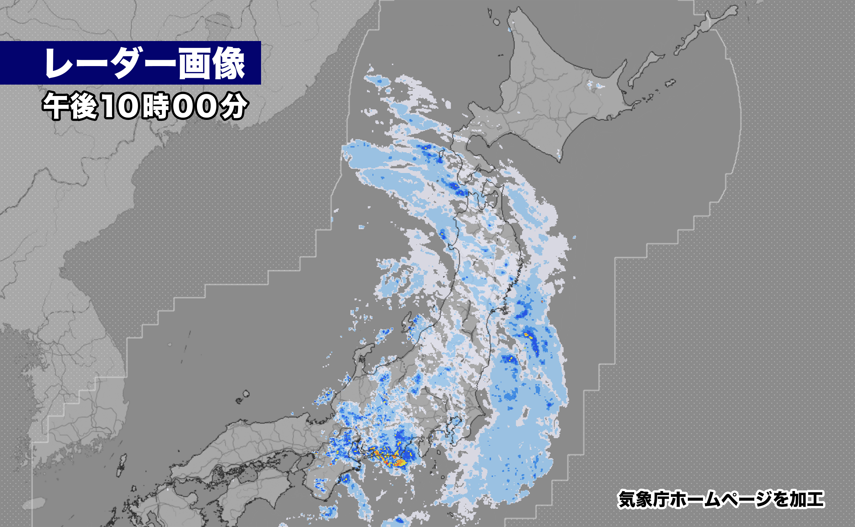
5日午後10時、気圧の谷の接近で渡島・檜山地方に雨雲がかかってきた。
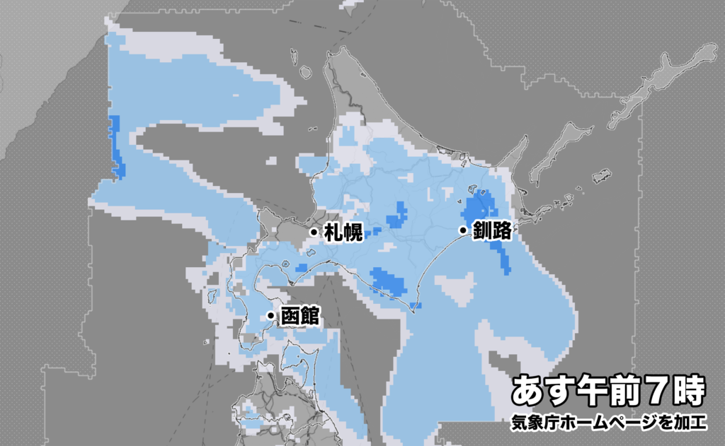
あすは低気圧が北海道付近を通過するため、広い範囲で朝から雨の予想。石狩地方では朝は雷を伴い、激しい雨が降るおそれがある。低気圧の発達の程度によっては宗谷地方で警報級の大雨も予想される。
2023年07月05日15時47分 札幌管区気象台発表
北海道地方では、6日は、大雨による低い土地の浸水や土砂災害、河川の増水に十分注意してください。また、竜巻などの激しい突風や落雷、ひょうに注意してください。

<気象概況>
 6日は北海道付近を低気圧が通過するでしょう。低気圧に向かって暖かく湿った空気が流入し、上空には寒気が流入するため、大気の状態が非常に不安定となる見込みです。

<防災事項>
 北海道地方では、6日朝から夜遅くにかけて、雷を伴った激しい雨が降り、大雨となる所があるでしょう。日本海側北部とオホーツク海側北部では、6日夕方から夜遅くにかけて大雨による低い土地の浸水や土砂災害、河川の増水に十分注意してください。低気圧の動向や雨雲の発達の程度によっては、警報級の大雨となるおそれがあります。
 また、北海道地方では、6日朝から夜遅くにかけて、竜巻などの激しい突風や落雷、ひょうのおそれがあります。農作物の管理や屋外の活動などに注意してください。
 発達した積乱雲の近づく兆しがある場合には、頑丈な建物内に移動するなど、安全の確保に努めてください。

<雨の予想>
6日に予想される1時間降水量は、いずれも多い所で、
 日本海側    30ミリ
 太平洋側    30ミリ
 オホーツク海側 30ミリ
5日18時から6日18時までに予想される24時間降水量は、いずれも多い所で、
 日本海側    60ミリ
 太平洋側    60ミリ
 オホーツク海側 40ミリ
その後、6日18時から7日18時までに予想される24時間降水量は、いずれも多い所で、
 日本海側    50から100ミリ
 オホーツク海側 50から100ミリ
At 10:00 PM on the 5th, rain clouds moved over the Oshima and Hiyama regions due to the approaching trough of low pressure.
Tomorrow, a low-pressure system is expected to pass through Hokkaido, resulting in rain across a wide area from the morning. In the Ishikari region, there is a possibility of thunderstorms and heavy rain in the morning.
Issued by Sapporo Regional Meteorological Observatory at 3:47 PM on July 5, 2023.
In the Hokkaido region, on the 6th, please be cautious of flooding in low-lying areas, landslides, and rising river levels caused by heavy rain. Also, be mindful of severe gusts such as tornadoes, lightning, and hail.<Weather Overview> On the 6th, a low-pressure system is expected to pass near Hokkaido. Warm and humid air will flow toward the low-pressure system, while cold air will flow in the upper atmosphere, resulting in highly unstable atmospheric conditions. <Disaster Prevention Measures> In the Hokkaido region, from the morning to late at night on the 6th, there may be heavy rain accompanied by thunderstorms in some areas, leading to heavy rainfall. In the northern part of the Japan Sea coast and the northern part of the Okhotsk Sea coast, please pay close attention to flooding in low-lying areas, landslides, and rising river levels caused by heavy rain from the evening to late at night on the 6th. Depending on the movement of the low-pressure system and the extent of cloud development, there is a possibility of heavy rain reaching warning levels. Additionally, from the morning to late at night on the 6th, there is a risk of severe gusts such as tornadoes, lightning, and hail in the Hokkaido region. Please take precautions regarding agricultural management and outdoor activities. If there are signs of developing cumulonimbus clouds, please seek shelter in sturdy buildings to ensure safety. <Rainfall Forecast> The expected hourly precipitation on the 6th will be significant in various areas: – Japan Sea coast: 30 mm – Pacific Ocean coast: 30 mm – Okhotsk Sea coast: 30 mm
The expected 24-hour precipitation from 6:00 PM on the 5th to 6:00 PM on the 6th will be significant in various areas:
- Japan Sea coast: 60 mm
- Pacific Ocean coast: 60 mm
- Okhotsk Sea coast: 40 mm
Subsequently, the expected 24-hour precipitation from 6:00 PM on the 6th to 6:00 PM on the 7th will be significant in various areas:
- Japan Sea coast: 50 to 100 mm
- Okhotsk Sea coast: 50 to 100 mm
コメント