
・7日(金)から10日(月)にかけ梅雨前線が活発に
・九州北部地方から北陸地方は大雨のおそれ
・総雨量は多いところで500〜600ミリ
・記録的な大雨になる可能性も
・土砂災害の危険度が一気に高まる見込み
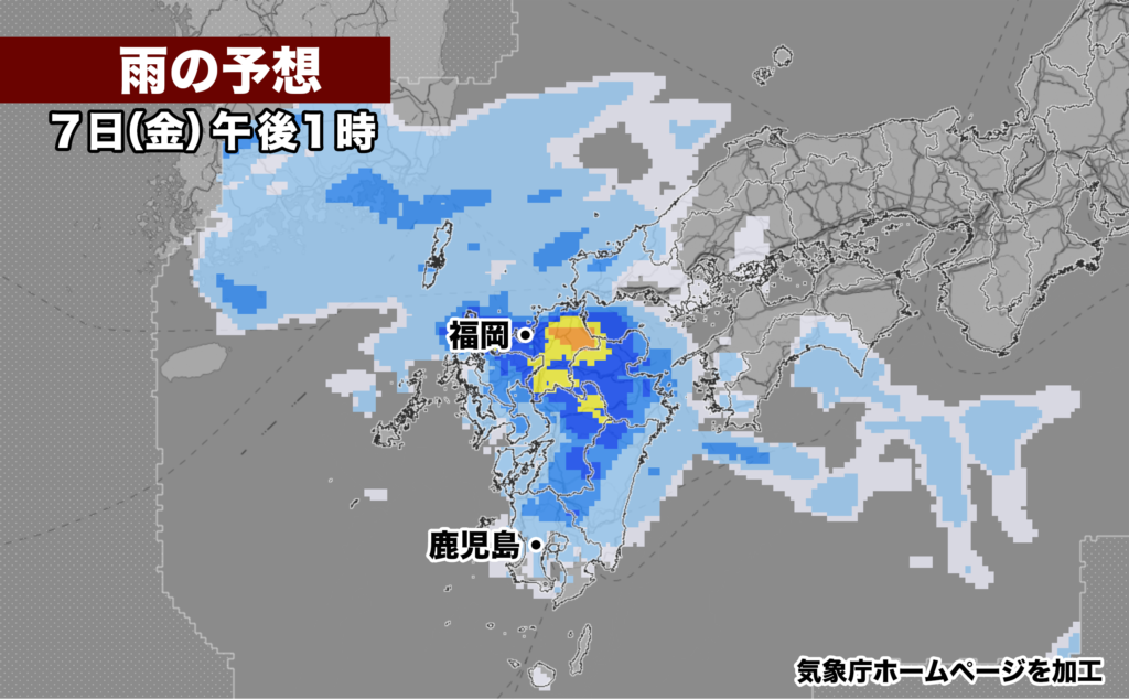
7日(金)から10日(月)頃にかけて、梅雨前線が九州北部から日本海に停滞し、広い範囲で大雨になるおそれ。今週は熊本県で線状降水帯が2回発生するなどして九州で大雨となった。7日(金)以降も、梅雨前線の活動が活発になり、九州北部地方から北陸地方の広い範囲にかけて非常に激しい雨が降る恐れがあり、土砂災害に警戒が必要。


【2023年07月06日15時58分 福岡管区気象台発表】
7日から10日頃にかけて九州北部地方に梅雨前線が停滞し、活動が活発となるため、大雨となるおそれがあります。土砂災害に厳重に警戒し、低い土地の浸水、河川の増水や氾濫に警戒してください。

 華中には梅雨前線があって、7日には西日本にのびだしてくるでしょう。その後、10日頃にかけて九州北部地方に梅雨前線が停滞し、前線に向かって暖かく湿った空気が流れ込むため、前線の活動が活発となる見込みです。
 このため、九州北部地方では、7日昼前から10日頃にかけて、断続的に雷を伴い激しい雨が降り、特に8日から9日は非常に激しい雨が降る所があるでしょう。これまでの大雨により地盤が緩んでいる所があり、10日頃にかけて雨が断続的に降り続くため、土砂災害の危険度が高くなる見込みです。

<雨の予想>
7日に予想される1時間降水量は、いずれも多い所で、
 山口県 20ミリ
 福岡県 40ミリ
 佐賀県 30ミリ
 長崎県 30ミリ
 大分県 30ミリ
 熊本県 30ミリ

6日18時から7日18時までに予想される24時間降水量は、いずれも多い所で、
 福岡県 80ミリ
 佐賀県 60ミリ
 長崎県 80ミリ
 大分県 70ミリ
 熊本県 80ミリ

その後、7日18時から8日18時までに予想される24時間降水量は、いずれも多い所で、
 山口県 100から200ミリ
 福岡県 100から200ミリ
 佐賀県 100から200ミリ
 長崎県 100から200ミリ
 大分県 100から200ミリ
 熊本県 100から200ミリ

その後、8日18時から9日18時までに予想される24時間降水量は、いずれも多い所で、
 山口県 200から300ミリ
 福岡県 200から300ミリ
 佐賀県 200から300ミリ
 長崎県 200から300ミリ
 大分県 200から300ミリ
 熊本県 200から300ミリ

<防災事項>
 土砂災害に厳重に警戒し、低い土地の浸水、河川の増水や氾濫に警戒してください。落雷や突風に注意してください。
From the 7th (Friday) to around the 10th (Monday), the stationary front is expected to linger over northern Kyushu and the Sea of Japan, posing a risk of widespread heavy rain. This week, heavy rain has occurred in Kyushu due to the two occurrence of a linear precipitation band. After the 7th (Friday), the activity of the stationary front is expected to become more active, and there is a risk of extremely heavy rain over a wide range from northern Kyushu to the Hokuriku region, requiring caution against sediment-related disasters.
Issued by Fukuoka Regional Meteorological Observatory at 15:58 PM on July 6, 2023.
During the period from the 7th to around the 10th, the stationary front will stagnate over northern Kyushu, and its activity will intensify, potentially leading to heavy rain. Please exercise utmost caution against sediment-related disasters and be prepared for flooding in low-lying areas as well as rising river levels.
There is a stationary front over central China, which is expected to extend to western Japan on the 7th. Subsequently, from around the 10th, the stationary front will stagnate over northern Kyushu, causing warm and humid air to flow towards the front, leading to increased frontal activity.
Therefore, in the northern Kyushu region, from around midday on the 7th to around the 10th, there will be intermittent thunderstorms accompanied by heavy rain, particularly on the 8th and 9th. There are areas where the ground has become loose due to previous heavy rain, and with the intermittent rainfall expected to continue around the 10th, the risk of sediment-related disasters is expected to be high.<Rainfall Forecast> The expected hourly precipitation on the 7th will be significant in various areas: – Yamaguchi Prefecture: 20 mm – Fukuoka Prefecture: 40 mm – Saga Prefecture: 30 mm – Nagasaki Prefecture: 30 mm – Oita Prefecture: 30 mm – Kumamoto Prefecture: 30 mm
The expected 24-hour precipitation from 6:00 PM on the 6th to 6:00 PM on the 7th will be significant in various areas:
- Fukuoka Prefecture: 80 mm
- Saga Prefecture: 60 mm
- Nagasaki Prefecture: 80 mm
- Oita Prefecture: 70 mm
- Kumamoto Prefecture: 80 mm
Afterward, the expected 24-hour precipitation from 6:00 PM on the 7th to 6:00 PM on the 8th will be significant in various areas:
- Yamaguchi Prefecture: 100 to 200 mm
- Fukuoka Prefecture: 100 to 200 mm
- Saga Prefecture: 100 to 200 mm
- Nagasaki Prefecture: 100 to 200 mm
- Oita Prefecture: 100 to 200 mm
- Kumamoto Prefecture: 100 to 200 mm
Following that, the expected 24-hour precipitation from 6:00 PM on the 8th to 6:00 PM on the 9th will be significant in various areas:
- Yamaguchi Prefecture: 200 to 300 mm
- Fukuoka Prefecture: 200 to 300 mm
- Saga Prefecture: 200 to 300 mm
- Nagasaki Prefecture: 200 to 300 mm
- Oita Prefecture: 200 to 300 mm
コメント