・梅雨前線が本州付近に停滞する見込み
・西日本〜北日本にかけ週末は大雨の恐れ
・10日(月)まで雷を伴い非常に激しい雨
・九州北部は総雨量が最大700ミリにも

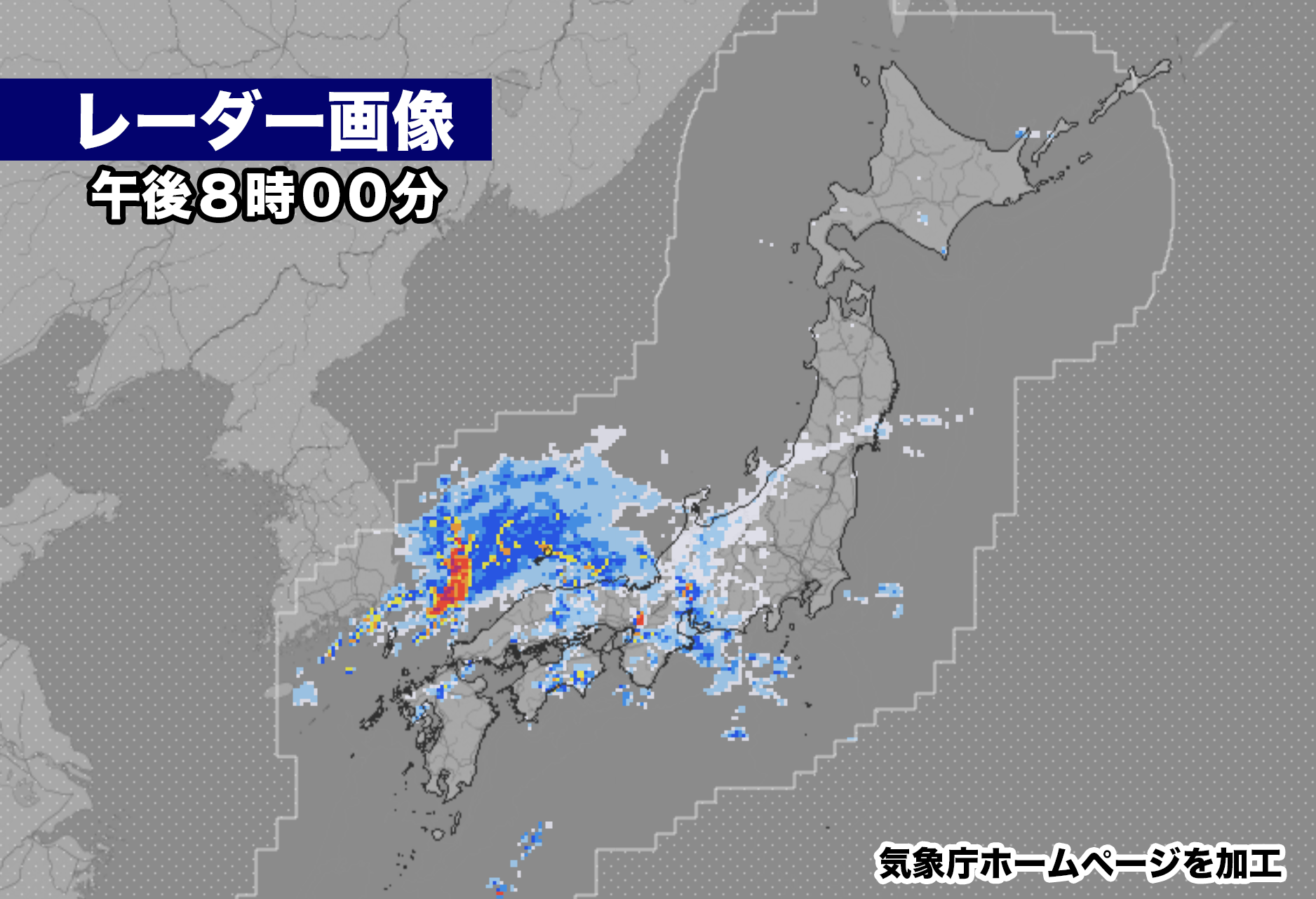
西日本にかかっている梅雨前線に向かって湿った空気が流れ込み、西日本では広く大気の状態が不安定になっている。現在、九州と中国・四国地方で弱い雨が降っていて、雨雲は近畿、東海、北陸にも広がり始めた。
かなり発達した雨雲が朝鮮半島の東海上にあり、こうした雨雲が10日(月)にかけて西日本、東日本、北日本にかかる見込みだ。梅雨前線の活動が活発化し、土砂災害の危険度がかなり高まるおそれがある。


【2023年07月07日16時36分 気象庁発表】
10日頃にかけて、梅雨前線が本州付近に停滞して前線の活動が活発となるため、西日本から北日本にかけての広い範囲で大雨となる見込みです。これまでの大雨により地盤の緩んでいる所があります。土砂災害に厳重に警戒し、低い土地の浸水、河川の増水や氾濫に警戒してください。

[気圧配置など]
 梅雨前線が華中から西日本を通り、日本の南にのびています。前線に向かって、暖かく湿った空気が流れ込んでおり、活動が活発になって雷を伴って激しい雨が降っている所があります。
 前線は、8日には東日本から北日本に北上し、10日頃にかけて本州付近に停滞する見込みです。

[防災事項]
 西日本から北日本にかけての広い範囲で、10日頃にかけて雷を伴った激しい雨や非常に激しい雨が降り、大雨となる見込みです。これまでの大雨により地盤の緩んでいる所では、少ない雨量でも土砂災害の危険度が非常に高まるおそれがあります。

8日18時までの24時間に予想される雨量は、多い所で、
九州北部地方  250ミリ
中国地方  150ミリ
関東甲信地方、北陸地方、東海地方 120ミリ

9日18時までの24時間に予想される雨量は、多い所で、
九州北部地方  200から300ミリ
関東甲信地方、東海地方、中国地方
100から200ミリ
東北地方、北陸地方、近畿地方
100から150ミリ

10日18時までの24時間に予想される雨量は、多い所で、
九州北部地方 100から200ミリの見込みです。

 10日頃にかけて土砂災害に厳重に警戒し、低い土地の浸水、河川の増水や氾濫に警戒してください。また、落雷や突風にも注意してください。
KADOKAWAグループ直営の電子書籍ストア BOOK☆WALKER
Moist air is flowing towards the rainy front over western Japan, causing a widespread instability in the atmosphere. Currently, light rain is falling in Kyushu, Chugoku, and Shikoku regions, and rain clouds are beginning to spread to Kinki, Tokai, and Hokuriku regions. Highly developed rain clouds are located over the sea east of the Korean Peninsula, and these rain clouds are expected to move over western, eastern, and northern Japan on July 10th (Monday). The activity of the rainy front will intensify, significantly increasing the risk of landslides.
Announcement by the Japan Meteorological Agency at 16:36 on July 7, 2023:
Between around July 10th, the rainy front will stall near Honshu, leading to an active front and widespread heavy rainfall over western to northern Japan. Some areas have experienced loosening of the ground due to previous heavy rains. Please exercise extreme caution against landslides, as well as flooding and overflow of rivers on low-lying lands.
[Pressure System and Others] The rainy front extends from central China through western Japan and south of Japan. Warm and moist air flows towards the front, resulting in active thunderstorms and heavy rainfall in some areas. The front is expected to move northward from eastern to northern Japan on the 8th and then stall near Honshu around July 10th.
[Disaster Prevention Measures] There is a possibility of heavy rain accompanied by thunderstorms and extremely heavy rain over a wide area from western to northern Japan around July 10th. In areas where the ground has already loosened due to previous heavy rains, even small amounts of rainfall can greatly increase the risk of landslides. The expected rainfall within a 24-hour period until 18:00 on the 8th is as follows:
- Northern Kyushu: 250 mm (locally)
- Chugoku region: 150 mm (locally)
- Kanto-Koshin region, Hokuriku region, Tokai region: 120 mm (locally)
The expected rainfall within a 24-hour period until 18:00 on the 9th is as follows:
- Northern Kyushu: 200-300 mm (locally)
- Kanto-Koshin region, Tokai region, Chugoku region: 100-200 mm (locally)
- Tohoku region, Hokuriku region, Kinki region: 100-150 mm (locally)
Please be aware that these are the expected rainfalls.
Exercise extreme caution against landslides and be vigilant for flooding and overflow of rivers on low-lying lands during the period around July 10th. Also, pay attention to lightning strikes and gusty winds.

コメント