
・佐賀市、唐津市に大雨警報
・昼過ぎ〜夕方に非常に激しい雨のおそれ
・梅雨前線の活動が活発に
・10日(月)にかけ総雨量は最大450ミリ
・梅雨末期の大雨に警戒を
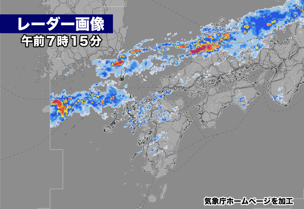
午前7時現在、佐賀県の佐賀市と唐津市に大雨警報が発表中。対馬海峡付近にある梅雨前線に向かって湿った空気が流れ込み、大気の状態が非常に不安定になっていて、けさは佐賀県の広い範囲で雨が降っている。きょうは昼過ぎから夕方にかけて雷を伴い非常に激しい雨が降るおそれ。土砂災害の危険度が急激に高まる可能性があり警戒が必要だ。
これから梅雨前線の活動が活発になり、佐賀県では10日(月)にかけて断続的に雨が降り、梅雨末期の大雨になるおそれがある。10日(月)までの総雨量は最大で450ミリに達する見込み。

【2023年07月08日05時28分 福岡管区気象台発表】
梅雨前線が10日にかけて対馬海峡付近に停滞し、活動が活発となるため、九州北部地方では大雨となるおそれがあります。土砂災害に厳重に警戒し、低い土地の浸水、河川の増水や氾濫に警戒してください。

 梅雨前線が10日にかけて対馬海峡付近に停滞する見込みです。前線に向かって、太平洋高気圧の縁を回る暖かく湿った空気が流れ込むため、前線の活動が活発となり、大気の状態が非常に不安定となるでしょう。
 このため、九州北部地方では、10日にかけて、断続的に雷を伴い激しい雨が降り、9日朝にかけては非常に激しい雨が降る所があるでしょう。また、落雷や竜巻などの激しい突風のおそれもあります。
 これまでの大雨で地盤が緩んでいる所があります。今後の雨で土砂災害の危険度がさらに高まる見込みです。

<雨の予想>
8日に予想される1時間降水量は、いずれも多い所で、
 山口県 60ミリ
 福岡県 70ミリ
 佐賀県 50ミリ
 長崎県 60ミリ
 大分県 60ミリ
 熊本県 50ミリ
9日に予想される1時間降水量は、いずれも多い所で、
 山口県 50ミリ
 福岡県 60ミリ
 佐賀県 50ミリ
 長崎県 40ミリ
 大分県 50ミリ
 熊本県 40ミリ

8日6時から9日6時までに予想される24時間降水量は、いずれも多い所で、
 山口県 250ミリ
 福岡県 250ミリ
 佐賀県 200ミリ
 長崎県 250ミリ
 大分県 200ミリ
 熊本県 200ミリ

その後、9日6時から10日6時までに予想される24時間降水量は、いずれも多い所で、
 山口県 100から150ミリ
 福岡県 100から200ミリ
 佐賀県 100から150ミリ
 長崎県 100から200ミリ
 大分県 100から200ミリ
 熊本県 100から150ミリ

その後、10日6時から11日6時までに予想される24時間降水量は、いずれも多い所で、
 山口県 50から100ミリ
 福岡県 50から100ミリ
 佐賀県 50から100ミリ
 長崎県 50から100ミリ
 大分県 50から100ミリ
 熊本県 50から100ミリ

<防災事項>
 土砂災害に厳重に警戒し、低い土地の浸水、河川の増水や氾濫に警戒してください。落雷や竜巻などの激しい突風に注意してください。発達した積乱雲の近づく兆しがある場合には、建物内に移動するなど、安全確保に努めてください。
As of 7:00 AM, heavy rain warnings are in effect for Saga City and Karatsu City in Saga Prefecture. Moist air is flowing towards the front extending from the Korean Peninsula to eastern Japan, making the atmospheric conditions highly unstable. It has been raining across a wide area of Saga Prefecture this morning. There is a possibility of extremely heavy rain accompanied by thunderstorms from the afternoon to evening today. There is a rapid increase in the risk of landslides, and caution is necessary.
The activity of the front is expected to become active, and intermittent rain is expected in Saga Prefecture until the 10th (Monday), with the potential for heavy rain in the late stage of the rainy season. The total rainfall until the 10th is expected to reach a maximum of 450 mm.
—–Announcement by the Fukuoka Regional Meteorological Observatory on July 8, 2023, 5:28 AM.
The front is expected to stall near the Tsushima Strait until the 10th, resulting in heavy rain in the northern part of Kyushu. Please exercise strict caution against landslides and be aware of low-lying areas prone to flooding and the rise of rivers and their potential overflow.
The front is expected to stall near the Tsushima Strait until the 10th. Warm and moist air circulates around the edge of the Pacific high pressure system towards the front, causing the front to become active and the atmospheric conditions to become highly unstable. Therefore, in the northern part of Kyushu, there will be intermittent heavy rain accompanied by thunderstorms until the 10th, and there may be extremely heavy rain in some areas until the morning of the 9th. There is also a risk of intense gusts such as lightning and tornadoes. There are areas where the ground has become loose due to previous heavy rainfall. The risk of landslides is expected to increase further with the upcoming rainfall.
[Rainfall Forecast] The expected hourly rainfall on the 8th is significant in many areas:
- Yamaguchi Prefecture: 60 mm
- Fukuoka Prefecture: 70 mm
- Saga Prefecture: 50 mm
- Nagasaki Prefecture: 60 mm
- Oita Prefecture: 60 mm
- Kumamoto Prefecture: 50 mm
The expected hourly rainfall on the 9th is significant in many areas:
- Yamaguchi Prefecture: 50 mm
- Fukuoka Prefecture: 60 mm
- Saga Prefecture: 50 mm
- Nagasaki Prefecture: 40 mm
- Oita Prefecture: 50 mm
- Kumamoto Prefecture: 40 mm
The expected 24-hour rainfall from 6:00 AM on the 8th to 6:00 AM on the 9th is significant in many areas:
- Yamaguchi Prefecture: 250 mm
- Fukuoka Prefecture: 250 mm
- Saga Prefecture: 200 mm
- Nagasaki Prefecture: 250 mm
- Oita Prefecture: 200 mm
- Kumamoto Prefecture: 200 mm
The expected 24-hour rainfall from 6:00 AM on the 9th to 6:00 AM on the 10th is significant in many areas:
- Yamaguchi Prefecture: 100-150 mm
- Fukuoka Prefecture: 100-200 mm
- Saga Prefecture: 100-150 mm
- Nagasaki Prefecture: 100-200 mm
- Oita Prefecture: 100-200 mm
- Kumamoto Prefecture: 100-150 mm
The expected 24-hour rainfall from 6:00 AM on the 10th to 6:00 AM on the 11th is significant in many areas:
- Yamaguchi Prefecture: 50-100 mm
- Fukuoka Prefecture: 50-100 mm
- Saga Prefecture: 50-100 mm
- Nagasaki Prefecture: 50-100 mm
- Oita Prefecture: 50-100 mm
- Kumamoto Prefecture: 50-100 mm
[Disaster Prevention Precautions]
Please exercise strict caution against landslides, be aware of low-lying areas prone to flooding and the rise of rivers and their potential overflow, and pay attention to intense gusts such as lightning and tornadoes. If there are signs of developing cumulonimbus clouds, seek shelter in sturdy buildings to ensure safety.
コメント