
・福岡県、山口県、島根県で梅雨末期の大雨
・1時間に50ミリ超の非常に激しい雨を観測
・土砂災害の危険度が高まる
・3県に警戒レベル4「避難指示」発令中
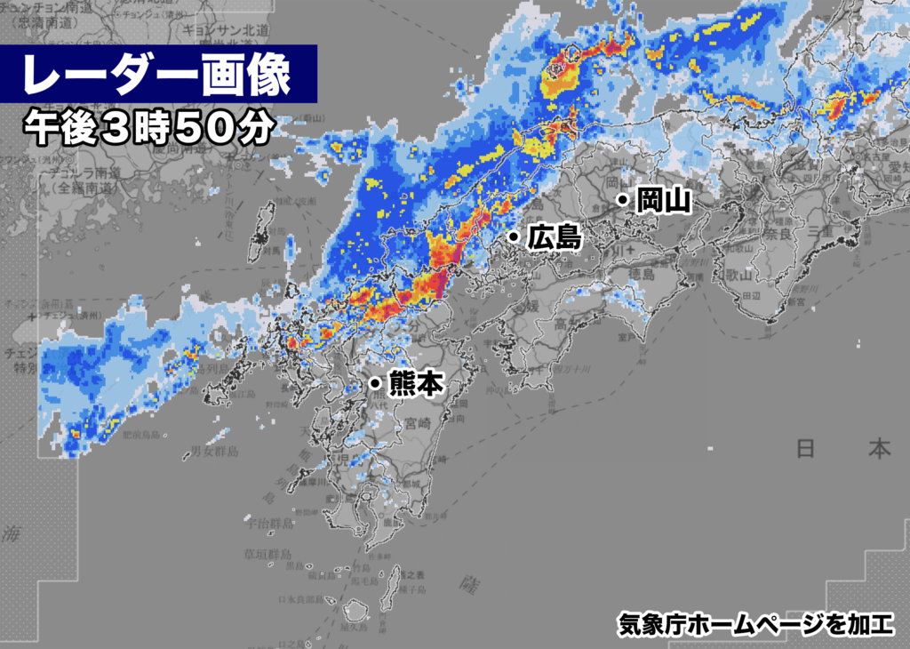
現在、福岡県と山口県に非常に発達した雨雲が流れ込んで大雨になっている。
対馬海峡付近にある梅雨前線に向かって湿った空気が流れ込み、九州北部地方と中国地方では大気の状態が非常に不安定に。気象庁のレーダー画像では1時間に80ミリ以上の猛烈な雨を示す紫色の表示が福岡県、山口県、島根県に見られ、所により予想以上の雨が降っているようだ。
雨雲は直線上に並んでいて、雨は各地でこの後も断続的に降る見込みで、土砂災害など梅雨末期の大雨による災害に厳重な警戒が必要。

午後3時20分までの1時間に、山口県下関市で52ミリの非常に激しい雨、福岡県福岡市中央区で29.5ミリの激しい雨が観測されている。
なお、福岡県北九州市小倉北区、山口県下関市、美祢市、周南市、島根県出雲市、松江市に警戒レベル4の避難指示が自治体から出されている。

【2023年07月08日11時00分 福岡管区気象台発表】
梅雨前線が10日にかけて対馬海峡付近に停滞し、活動が活発となるため、九州北部地方では大雨となるおそれがあります。土砂災害に厳重に警戒し、低い土地の浸水、河川の増水や氾濫に警戒してください。

 梅雨前線が10日にかけて対馬海峡付近に停滞する見込みです。前線に向かって、太平洋高気圧の縁を回る暖かく湿った空気が流れ込んでいるため、前線の活動が活発となり、大気の状態が非常に不安定となっています。
 このため、九州北部地方では、10日にかけて、断続的に雷を伴い激しい雨が降り、9日朝にかけては非常に激しい雨が降る所があるでしょう。また、落雷や竜巻などの激しい突風のおそれもあります。
 これまでの大雨で地盤が緩んでいる所があります。今後の雨で土砂災害の危険度がさらに高まる見込みです。

<雨の予想>
8日に予想される1時間降水量は、いずれも多い所で、
 山口県 60ミリ
 福岡県 70ミリ
 佐賀県 50ミリ
 長崎県 60ミリ
 大分県 50ミリ
 熊本県 50ミリ
9日に予想される1時間降水量は、いずれも多い所で、
 山口県 50ミリ
 福岡県 70ミリ
 佐賀県 50ミリ
 長崎県 40ミリ
 大分県 60ミリ
 熊本県 50ミリ

8日12時から9日12時までに予想される24時間降水量は、いずれも多い所で、
 山口県 250ミリ
 福岡県 250ミリ
 佐賀県 200ミリ
 長崎県 200ミリ
 大分県 200ミリ
 熊本県 200ミリ

その後、9日12時から10日12時までに予想される24時間降水量は、いずれも多い所で、
 山口県 50から100ミリ
 福岡県 100から200ミリ
 佐賀県 100から200ミリ
 長崎県 100から200ミリ
 大分県 100から200ミリ
 熊本県 100から200ミリ

その後、10日12時から11日12時までに予想される24時間降水量は、いずれも多い所で、
 山口県 50から100ミリ
 福岡県 50から100ミリ
 佐賀県 50から100ミリ
 長崎県 50から100ミリ
 大分県 50から100ミリ
 熊本県 50から100ミリ

<防災事項>
 土砂災害に厳重に警戒し、低い土地の浸水、河川の増水や氾濫に警戒してください。落雷や竜巻などの激しい突風に注意してください。発達した積乱雲の近づく兆しがある場合には、建物内に移動するなど、安全確保に努めてください。
Currently, highly developed rain clouds are flowing into Fukuoka and Yamaguchi Prefectures, causing heavy rainfall. Moist air is flowing towards the Strait of Tsushima, where the seasonal rain front is located, leading to highly unstable atmospheric conditions in northern Kyushu and the Chugoku region. The radar images from the Japan Meteorological Agency show purple indications, indicating intense rainfall of over 80 mm per hour, in Fukuoka, Yamaguchi, and Shimane Prefectures, suggesting that some areas are experiencing rainfall exceeding expectations. The rain clouds are aligned in a linear pattern, and rain is expected to continue intermittently in various areas. Vigilance against disasters such as landslides due to heavy rainfall during the late phase of the rainy season is necessary.
As of 3:20 PM, extremely heavy rainfall of 52 mm per hour was observed in Shimonoseki City, Yamaguchi Prefecture, and heavy rainfall of 29.5 mm per hour was observed in Chuo Ward, Fukuoka City. It should be noted that evacuation advisories at level 4 have been issued by local municipalities for Kokura Kita Ward in Kitakyushu City, Shimonoseki City, Mine City, Shunan City in Yamaguchi Prefecture, Izumo City , and Matsue City in Shimane Prefecture.
—–Announcement by the Fukuoka District Meteorological Observatory, July 8, 2023, 11:00 AM
The seasonal rain front is expected to stagnate near the Umi Sea region on the 10th, leading to intensified activities. As a result, heavy rainfall is expected in northern Kyushu. Please exercise extreme caution against landslides, flooding of low-lying areas, and increased river levels and flooding.
The seasonal rain front is expected to stagnate near the Umi Sea region on the 10th. Warm, humid air is flowing into the front, encircling the edge of the Pacific high-pressure system. As a result, the front’s activities have become more active, and the atmospheric conditions have become highly unstable. Therefore, in northern Kyushu, there will be intermittent heavy rainfall accompanied by thunderstorms during the 10th, and extremely heavy rainfall is expected in some areas until the morning of the 9th. There is also a possibility of intense thunderstorms such as lightning strikes and tornadoes. Some areas have loosened ground due to the previous heavy rainfall, and the risk of landslides is expected to increase with the upcoming rainfall.<Rainfall Forecast> The expected hourly rainfall on the 8th is as follows: – Yamaguchi Prefecture: 60 mm – Fukuoka Prefecture: 70 mm – Saga Prefecture: 50 mm – Nagasaki Prefecture: 60 mm – Oita Prefecture: 50 mm – Kumamoto Prefecture: 50 mm
The expected hourly rainfall on the 9th is as follows:
- Yamaguchi Prefecture: 50 mm
- Fukuoka Prefecture: 70 mm
- Saga Prefecture: 50 mm
- Nagasaki Prefecture: 40 mm
- Oita Prefecture: 60 mm
- Kumamoto Prefecture: 50 mm
The expected 24-hour rainfall from 12:00 PM on the 8th to 12:00 PM on the 9th is as follows:
- Yamaguchi Prefecture: 250 mm
- Fukuoka Prefecture: 250 mm
- Saga Prefecture: 200 mm
- Nagasaki Prefecture: 200 mm
- Oita Prefecture: 200 mm
- Kumamoto Prefecture: 200 mm
Subsequently, the expected 24-hour rainfall from 12:00 PM on the 9th to 12:00 PM on the 10th is as follows:
- Yamaguchi Prefecture: 50-100 mm
- Fukuoka Prefecture: 100-200 mm
- Saga Prefecture: 100-200 mm
- Nagasaki Prefecture: 100-200 mm
- Oita Prefecture: 100-200 mm
- Kumamoto Prefecture: 100-200 mm
Finally, the expected 24-hour rainfall from 12:00 PM on the 10th to 12:00 PM on the 11th is as follows:
- Yamaguchi Prefecture: 50-100 mm
- Fukuoka Prefecture: 50-100 mm
- Saga Prefecture: 50-100 mm
- Nagasaki Prefecture: 50-100 mm
- Oita Prefecture: 50-100 mm
- Kumamoto Prefecture: 50-100 mm
<Disaster Prevention Information> Exercise extreme caution against landslides, flooding of low-lying areas, and increased river levels and flooding. Pay attention to intense phenomena such as lightning strikes and tornadoes. If there are signs of developing cumulonimbus clouds, move indoors to ensure safety.
コメント