
梅雨前線が日本海から東北を通って太平洋に伸びている。
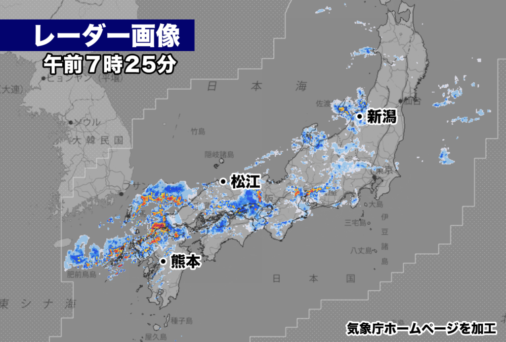
この梅雨前線に向かって湿った空気が流れ込み、西日本から東日本にかけて大気の非常に不安定な状況が続く。レーダー画像では発達した雨雲が九州、中国・四国、近畿、東海、北陸、関東にみられ、大雨による災害リスクが高まっている状況。
午前6時40分までに観測された最大1時間雨量では、山口県下関で55ミリ、長崎県壱岐市で42.5ミリ、福岡県福岡市で42ミリ、広島県三原市で41ミリなど所により非常に激しい雨が降っている。
きのうから大雨になっている島根県出雲市では川の水があふれ住宅が水につかったり、土砂崩れなどの被害が出ているようだ。
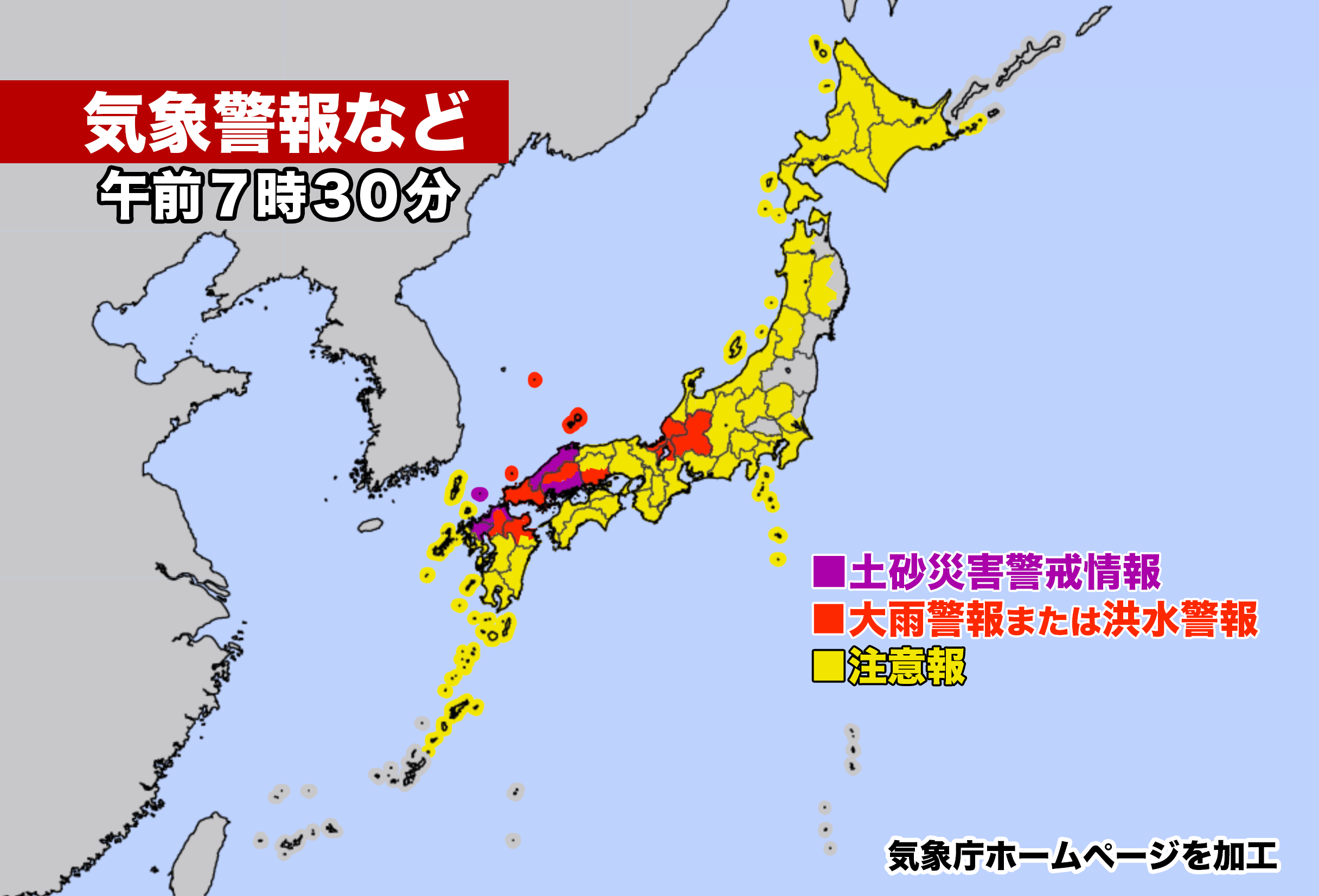
午前7時現在、島根県の東部と西部、広島県南部、福岡県の福岡地方と北九州地方、佐賀県の南部と北部に土砂災害警戒情報が発表されている。きょうも各地で土砂災害の危険度が急激に高まる恐れがある。最新の気象情報に留意し、周囲の状況を確認しつつ身の安全を守る行動が必要だ。
【2023年07月09日05時03分 気象庁発表】
梅雨前線が11日にかけて、西日本から東北地方付近に停滞するため、西日本から東北地方にかけての広い範囲で大雨となる見込みです。西日本から東日本では、これまでの大雨により地盤の緩んでいる所があります。土砂災害に厳重に警戒し、低い土地の浸水、河川の増水や氾濫に警戒してください。また、西日本から東日本では、大気の状態が非常に不安定となるため、落雷や竜巻などの激しい突風に注意してください。
[気圧配置など]
梅雨前線が西日本から東北地方にのびており、11日にかけて停滞する見込みです。前線に向かって、暖かく湿った空気が流れ込んでいるため、前線の活動が活発となっており、西日本を中心に雷を伴って非常に激しい雨が降っている所があります。
[防災事項]
西日本から東日本では11日にかけて、東北地方では9日は雷を伴った非常に激しい雨や激しい雨が降り、大雨となる見込みです。西日本から東日本では、これまでの大雨により地盤が緩んでおり、土砂災害の危険度が高まっている所があります。
10日6時までの24時間に予想される雨量は、多い所で、
九州北部地方 180ミリ
中国地方 150ミリ
関東甲信地方、北陸地方、東海地方、近畿地方 100ミリ
東北地方 80ミリ
11日6時までの24時間に予想される雨量は、多い所で、
九州北部地方 100から150ミリ
関東甲信地方、北陸地方、近畿地方、中国地方 50から100ミリ
12日6時までの24時間に予想される雨量は、多い所で、
北陸地方、中国地方、九州北部地方 50から100ミリ
の見込みです。
西日本から東日本では11日にかけて、土砂災害に厳重に警戒し、低い土地の浸水、河川の増水や氾濫に警戒してください。また、西日本から東日本では落雷や竜巻などの激しい突風にも注意してください。発達した積乱雲の近づく兆しがある場合には、建物内に移動するなど、安全確保に努めてください。
The rainy front extends from the Sea of Japan through Tohoku and stretches towards the Pacific Ocean. Moist air is flowing towards this rainy front, creating a highly unstable atmospheric condition from western to eastern Japan. Radar images show developed rain clouds over Kyushu, Chugoku/Shikoku, Kinki, Tokai, Hokuriku, and Kanto regions, indicating an increased risk of heavy rainfall-related disasters. The maximum hourly rainfall observed until 6:40 AM includes 55 millimeters in Shimonoseki, Yamaguchi Prefecture, 42.5 millimeters in Iki City, Nagasaki Prefecture, 42 millimeters in Fukuoka City, Fukuoka Prefecture, and 41 millimeters in Mihara City, Hiroshima Prefecture, with extremely heavy rainfall occurring in some areas.
In Izumo City, Shimane Prefecture, where heavy rain has persisted since yesterday, there have been reports of overflowing rivers, homes being submerged in water, and landslides causing damage. As of 7:00 AM, landslide warnings have been issued for the eastern and western parts of Shimane Prefecture, southern Hiroshima Prefecture, Fukuoka region, and northern Kyushu region of Fukuoka Prefecture, as well as the southern and northern parts of Saga Prefecture. The risk of landslides is expected to rapidly increase in various regions today. It is important to stay updated on the latest weather information and be aware of the surrounding conditions to ensure personal safety.
Released by the Japan Meteorological Agency at 5:03 AM on July 9, 2023:
The rainy front is expected to stagnate over western to northeastern Japan until the 11th, resulting in heavy rainfall over a wide area from western to northeastern Japan. Due to the previous heavy rain, some areas in western to eastern Japan have loose ground, requiring strict vigilance against landslides, flooding in low-lying areas, and increased river water levels and flooding. Additionally, in western to eastern Japan, the atmospheric conditions are highly unstable, so please be cautious of intense gusts such as lightning and tornadoes.
[Pressure distribution, etc.] The rainy front stretches from western to northeastern Japan and is expected to stagnate until the 11th. Warm and humid air is flowing towards the front, causing increased activity along the front and resulting in extremely heavy rainfall with thunderstorms mainly over western Japan.
[Disaster prevention measures] From western to eastern Japan, on the 11th, there is a possibility of very heavy rain with thunderstorms or heavy rain. Due to the previous heavy rain, some areas in western to eastern Japan have loose ground, increasing the risk of landslides. The expected rainfall in the 24-hour period until 6:00 AM on the 10th is significant:
- Northern Kyushu region: up to 180 millimeters
- Chugoku region: up to 150 millimeters
- Kanto-Koshin region, Hokuriku region, Tokai region, Kinki region: up to 100 millimeters
- Tohoku region: up to 80 millimeters The expected rainfall in the 24-hour period until 6:00 AM on the 11th is significant:
- Northern Kyushu region: 100 to 150 millimeters
- Kanto-Koshin region, Hokuriku region, Kinki region, Chugoku region: 50 to 100 millimeters The expected rainfall in the 24-hour period until 6:00 AM on the 12th is significant:
- Hokuriku region, Chugoku region, Northern Kyushu region: 50 to 100 millimeters Please take strict precautions against landslides from western to eastern Japan until the 11th. Be cautious of flooding in low-lying areas, increased river water levels, and flooding. Also, pay attention to intense gusts such as lightning and tornadoes. If there are signs of developing cumulonimbus clouds, take measures to secure your safety, such as moving indoors.
コメント