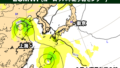
・25日火曜日は非常に強い勢力
・26日水曜日以降、石垣島などは暴風域に
・26日水曜日の夜に台湾を直撃
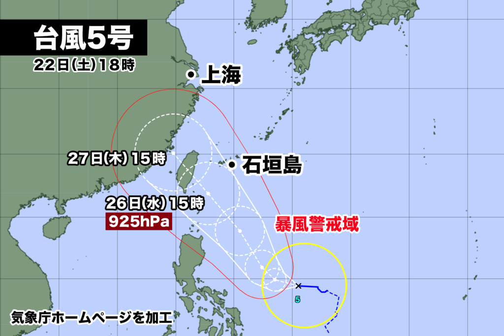
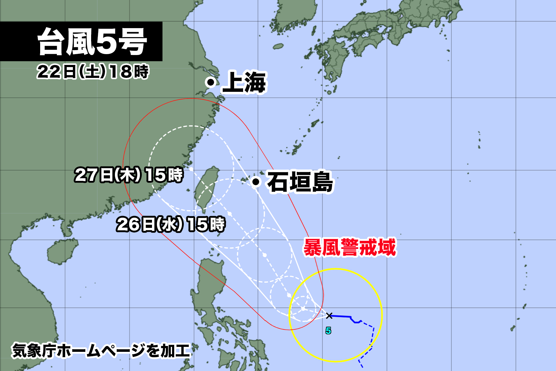
台風5号は22日土曜日午後6時現在、フィリピンの東を1時間に10km/hのスピードで西に進んでいる。
中心気圧は998hPa、中心付近の最大風速は20m/s、最大瞬間風速は30m/s。中心の東側440km、西側330kmに風速15m/s以上の強風域を伴っている。
台風はこの後は発達しながらゆっくり北西方向に進み、24日月曜日は強い勢力に、25日火曜日は非常に強い勢力になる。勢力のピークは26日水曜日で、中心気圧は925hPaまで低下する見込み。
台風が予報円の中心を進んだ場合、26日水曜日の夜から27日木曜日の朝にかけて台湾を直撃、石垣島や西表島の八重山諸島には26日水曜日の夜に最も接近する。
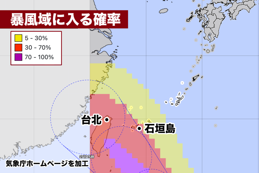
台風の接近に伴い八重山諸島は26日水曜日から風速25m/s以上の暴風域に入る可能性が高い。その確率は現時点で最大70%。
直撃の可能性が高い台湾は、ほぼ100%の確率で暴風域に入る見込みだ。
As of 6 p.m. on Saturday, the 22nd, Typhoon DOKSURI is moving westward at a speed of 10 km/h off the Eastern Coast of the Philippines. The central atmospheric pressure is 998 hPa, with maximum sustained winds near the center at 20 m/s and maximum gusts reaching 30 m/s. On the eastern side of the center, strong winds of 15 m/s or more extend up to 440 km, and on the western side, they extend up to 330 km.
The typhoon is expected to gradually intensify and move in a northwesterly direction. By Monday, the 24th, it will reach a strong intensity, and by Tuesday, the 25th, it will become a very powerful typhoon. The peak intensity is expected to be on Wednesday, the 26th, with the central atmospheric pressure possibly dropping to 925 hPa.
If the typhoon follows the forecasted track’s center, it will make a direct hit on Taiwan from Wednesday night, the 26th, until Thursday morning, the 27th. It will come closest to the Yaeyama Islands, including Ishigaki-jima and Iriomote-jima, on Wednesday night, the 26th.
As Typhoon approaches, there is a high probability that the Yaeyama Islands will enter the area of destructive winds with wind speeds of 25 m/s or higher starting from Wednesday, the 26th. The probability of this happening is currently at a maximum of 70%.
For Taiwan, which is at high risk of a direct hit, there is an almost 100% probability of entering the area of destructive winds.
コメント