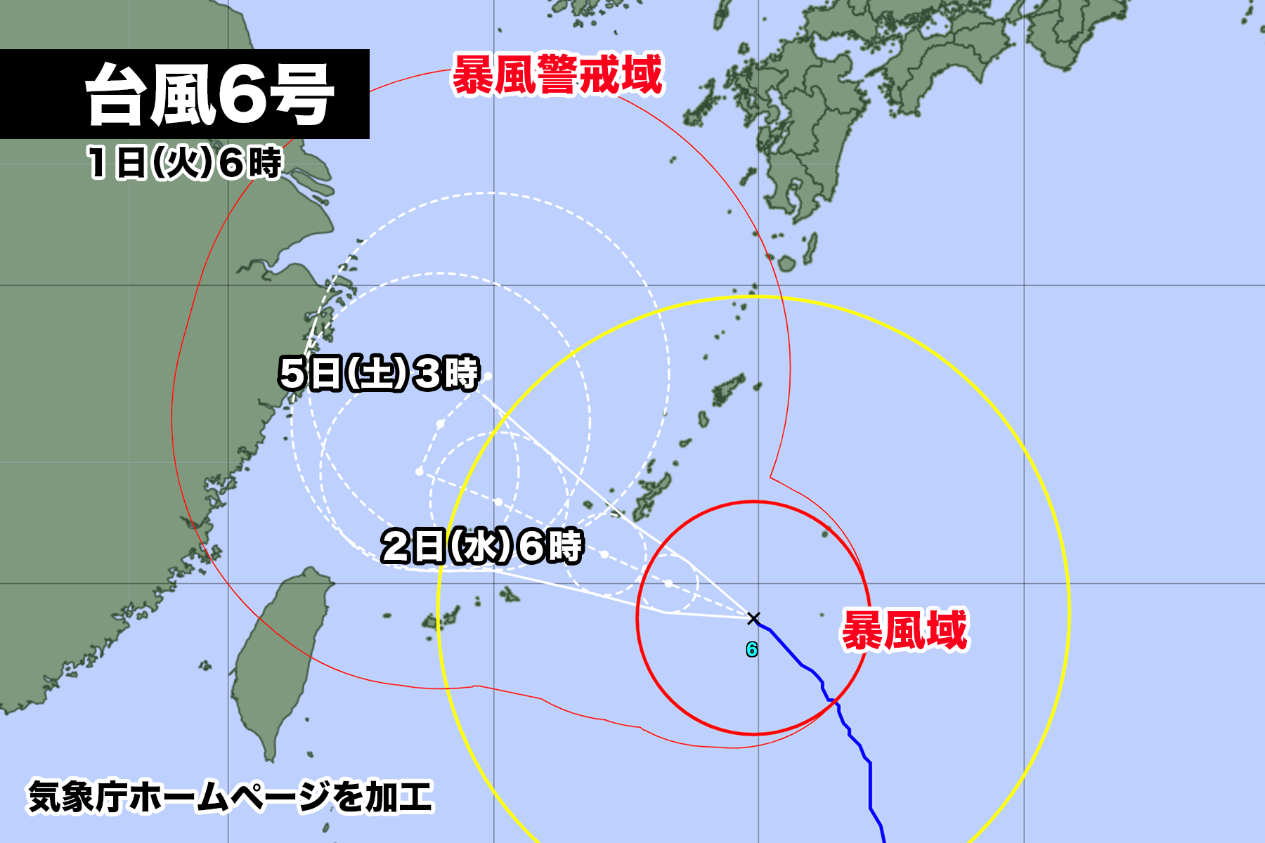

大型で非常に強い勢力の台風6号が沖縄に向かって進んでいる。
1日火曜日午前6時現在、中心気圧は935hPa、中心付近の最大風速は45m/ s、最大瞬間風速は65m/sで、あすは中心気圧がさらに下がる予想。
台風は2日水曜日の明け方から昼前の間に沖縄本島地方に最も接近し、先島諸島には2日夕方から3日木曜日の午前中までの間に最も接近する。
台風は東シナ海で進行スピードが遅くなるため、3日以降も沖縄は大荒れの天気となり、台風の影響が長引く恐れがある。
また今週後半、台風は東シナ海で進行方向を東寄りに変えて、来週前半は奄美地方に接近する可能性がある。ただ現時点では予報円が大きく、台風の進むルートがはっきりしないので、今後、予報が大きく変わることも考えられる。


2023年08月01日05時17分 沖縄気象台発表
大型で非常に強い台風第6号は、3日にかけて非常に強い勢力を維持したまま沖縄地方にかなり接近する見込みです。沖縄地方では台風の影響が長引くおそれがあります。暴風や高波、高潮に厳重に警戒し、土砂災害や低い土地の浸水、河川の増水や氾濫に警戒してください。

[台風の現況]
 大型で非常に強い台風第6号は、1日3時には南大東島の南南西約210キロの北緯24度05分、東経130度20分にあって、1時間におよそ20キロの速さで北西へ進んでいます。中心の気圧は935ヘクトパスカル、中心付近の最大風速は45メートル、最大瞬間風速は65メートルで中心から半径220キロ以内では風速25メートル以上の暴風となっています。また、中心から半径600キロ以内では風速15メートル以上の強い風が吹いています。

[台風の予想]
 大型で非常に強い台風第6号は、発達しながら次第に進路を西よりに変えて、非常に強い勢力を維持したまま、3日にかけて沖縄地方にかなり接近する見込みです。なお、台風は東シナ海で速度が遅くなるため、3日以降も沖縄地方では大荒れとなり、台風の影響が長引くおそれがあります。

[防災事項]
<暴風・強風>
 大東島地方では東の非常に強い風が吹いており、沖縄本島地方では北東の強い風が吹いています。大東島地方では1日昼過ぎまで暴風に警戒してください。沖縄本島地方では1日昼前から暴風となり、2日にかけては、一部の住家が倒壊するおそれもある猛烈な風の吹く所がある見込みです。風が強まる前に頑丈な建物の中に移動するとともに、屋内では窓から離れるなど暴風に厳重に警戒してください。先島諸島では、1日は北西の風が次第に強まり、1日夜には暴風となる所があるでしょう。なお、沖縄本島地方と先島諸島では、3日も暴風となる見込みです。暴風に警戒してください。

1日に予想される最大風速(最大瞬間風速)
 沖縄本島地方 40メートル(60メートル)
 大東島地方  25メートル(35メートル)
 先島諸島   25メートル(35メートル)
2日に予想される最大風速(最大瞬間風速)
 沖縄本島地方 45メートル(65メートル)
 先島諸島   30メートル(45メートル)
 大東島地方  20メートル(30メートル)
3日に予想される最大風速(最大瞬間風速)
 沖縄本島地方 25から29メートル(35から45メートル)
 先島諸島   25から29メートル(35から45メートル)
 大東島地方  15から19メートル(20から30メートル)

        暴風警報発表予定   最接近
 大東島地方  発表中        現在最も接近
 沖縄本島地方 発表中        2日明け方から昼前
 先島諸島   1日夕方       2日夕方から3日午前中

<高波>
 沖縄地方の沿岸の海域ではうねりを伴い、沖縄本島地方と大東島地方では猛烈にしけています。先島諸島ではしけており次第に大しけとなり、2日は猛烈にしける見込みです。沖縄地方では、3日にかけてうねりを伴う高波に厳重に警戒してください。
 なお、台風は東シナ海で速度が遅くなるため、沖縄地方では5日頃にかけて警報級の高波が続くおそれがあります。

1日に予想される波の高さ
 沖縄本島地方 12メートル うねりを伴う
 大東島地方  10メートル うねりを伴う
 先島諸島    8メートル うねりを伴う
2日に予想される波の高さ
 沖縄本島地方 12メートル うねりを伴う
 先島諸島    9メートル うねりを伴う
 大東島地方   7メートル うねりを伴う
3日に予想される波の高さ
 沖縄本島地方  9メートルを超える うねりを伴う
 先島諸島    9メートルを超える うねりを伴う
 大東島地方   6から8メートル  うねりを伴う

<大雨>
 沖縄本島地方では、2日にかけて多い所で1時間に50ミリの非常に激しい雨が降り、警報級の大雨となる見込みです。土砂災害や低い土地の浸水、河川の増水や氾濫に警戒してください。雨雲の発達の程度によっては、3日にかけて警報級の大雨が続くおそれがあります。
 先島諸島では、2日は多い所で1時間に50ミリの非常に激しい雨が降る見込みです。なお、台風の進路等によっては、2日から3日にかけて警報級の大雨となるおそれがあります。

 2日6時までの24時間に予想される雨量は、多い所で、
  沖縄本島地方 150ミリ
  先島諸島    80ミリ
 3日6時までの24時間に予想される雨量は、多い所で、
  沖縄本島地方 100から200ミリ
  先島諸島   100から200ミリ
 4日6時までの24時間に予想される雨量は、多い所で、
  沖縄本島地方 100から150ミリ
  先島諸島   100から150ミリ

<高潮>
 沖縄地方では、台風の影響と大潮の時期が重なるため4日頃にかけて潮位が高くなる見込みです。沖縄本島地方では2日にかけて、先島諸島では2日は警報級の高潮となる見込みです。海岸や河口付近の低い土地では、高潮による浸水や冠水に厳重に警戒してください。
 潮位が堤防を越えなくても、潮位が高い中で高波があると、波が海岸堤防を越えるおそれもあります。高潮や、高潮と重なりあった高波による浸水などにも厳重に警戒してください。
 なお、台風の進路等によっては、沖縄本島地方と先島諸島では4日頃にかけて警報級の高潮となるおそれがあります。

 予想される最高潮位(標高)と高潮に警戒・注意が必要な期間
  沖縄本島地方 2.8メートル 1日夕方から夜遅く
         3.0メートル 2日未明から昼前
  先島諸島   1.5メートル 1日夜のはじめ頃から夜遅く
         2.3メートル 2日明け方から昼前

<雷・突風>
 沖縄地方では、2日にかけて積乱雲が発達し、落雷や竜巻などの激しい突風による被害の起こるおそれがありますので、屋外活動などには注意してください。発達した積乱雲の近づく兆しがある場合には、頑丈な建物内に移動するなど、安全確保に努めてください。
As of 6:00 AM on Tuesday, Typhoon No. 6, a large and extremely powerful typhoon, is moving towards Okinawa. The central atmospheric pressure is 935 hPa, the maximum wind speed near the center is 45 m/s, and the maximum gust speed is 65 m/s. The central atmospheric pressure is expected to decrease further tomorrow. The typhoon is expected to come closest to the Okinawa Main Island region between early morning and noon on Wednesday, the 2nd, and to the Amami Islands between the evening of the 2nd and the morning of the 3rd, Thursday.
Due to the slow progress of the typhoon in the East China Sea, Okinawa is expected to experience severe weather even after the 3rd, and there is a possibility that the impact of the typhoon will prolong. Additionally, in the latter half of this week, the typhoon may change its course eastward in the East China Sea and could approach the Amami region in the first half of next week. However, at this time, the forecast range is broad, and the typhoon’s route may change significantly in the future.
Announced by the Okinawa Meteorological Observatory at 5:17 AM on August 1, 2023: Typhoon No. 6, a large and extremely powerful typhoon, is expected to come quite close to the Okinawa region while maintaining its very strong force until the 3rd. There is a possibility that the impact of the typhoon may prolong in the Okinawa region. Please exercise extreme caution against strong winds, high waves, and high tides. Be vigilant against mudslides, lowland inundation, and river flooding.
[Typhoon Current Status]
As of 3:00 AM, Typhoon No. 6, a large and extremely powerful typhoon, is located at approximately 210 kilometers south-southwest of Minami Daito Island, with a latitude of 24 degrees 05 minutes north and a longitude of 130 degrees 20 minutes east. It is moving northwest at a speed of approximately 20 kilometers per hour. The central atmospheric pressure is 935 hPa, the maximum wind speed near the center is 45 meters per second, and the maximum gust speed is 65 meters per second. Within a radius of 220 kilometers from the center, there are storm winds with speeds of 25 meters per second or more, and within a radius of 600 kilometers from the center, strong winds with speeds of 15 meters per second or more are blowing.
[Typhoon Forecast]
Typhoon No. 6, a large and extremely powerful typhoon, is expected to gradually change its course from the west and come quite close to the Okinawa region while maintaining its very strong force until the 3rd. Since the speed of the typhoon will slow down in the East China Sea, severe weather is expected to continue in the Okinawa region even after the 3rd, and there is a possibility that the impact of the typhoon may prolong.
[Disaster Precautions]
<Storm and Strong Winds> In the Minami Daito Island region, extremely strong winds from the east are blowing, and in the Okinawa Main Island region, strong winds from the northeast are blowing. Please be on guard against storm winds until early afternoon on the 1st in the Minami Daito Island region. In the Okinawa Main Island region, storm winds are expected from before noon on the 1st, and on the 2nd, there is a possibility of violent winds in some areas, with the likelihood of some houses collapsing. Before the wind intensifies, move into sturdy buildings and exercise extreme caution against storm winds. In the Amami Islands, northwest winds will gradually strengthen on the 1st and become stormy at night. Furthermore, storm winds are expected to continue in the Okinawa Main Island region and the Amami Islands on the 3rd. Please be vigilant against storm winds.
Expected maximum wind speeds (maximum gust speeds) on the 1st:
Okinawa Main Island region: 40 meters per second (60 meters per second)
Minami Daito Island region: 25 meters per second (35 meters per second)
Amami Islands: 25 meters per second (35 meters per second)
Expected maximum wind speeds (maximum gust speeds) on the 2nd:
Okinawa Main Island region: 45 meters per second (65 meters per second)
Amami Islands: 30 meters per second (45 meters per second)
Minami Daito Island region: 20 meters per second (30 meters per second)
Expected maximum wind speeds (maximum gust speeds) on the 3rd:
Okinawa Main Island region: 25 to 29 meters per second (35 to 45 meters per second)
Amami Islands: 25 to 29 meters per second (35 to 45 meters per second)
Minami Daito Island region: 15 to 19 meters per second (20 to 30 meters per second)
*Note: Storm warnings will be announced as follows, and the time of closest approach is indicated. Minami Daito Island region: In effect (Currently closest) Okinawa Main Island region: In effect (From early morning on the 2nd to noon) Amami Islands: Evening on the 1st (From the evening on the 2nd to the morning of the 3rd)<High Waves> In the coastal waters of the Okinawa region, there are swells, and in the Okinawa Main Island and Minami Daito Island regions, waves are extremely rough. In the Amami Islands, the waves are rough and will become very rough on the 2nd. Please exercise extreme caution against high waves with swells in the Okinawa region. Additionally, due to the slow progress of the typhoon in the East China Sea, warning-level high waves may continue in the Okinawa region around the 5th.
Expected wave heights on the 1st:
Okinawa Main Island region: 12 meters with swells
Minami Daito Island region: 10 meters with swells
Amami Islands: 8 meters with swells, becoming very rough on the 2nd.
Expected wave heights on the 2nd:
Okinawa Main Island region: 12 meters with swells
Amami Islands: 9 meters with swells
Minami Daito Island region: 7 meters with swells
Expected wave heights on the 3rd:
Okinawa Main Island region: Exceeding 9 meters with swells
Amami Islands: Exceeding 9 meters with swells
Minami Daito Island region: 6 to 8 meters with swells
<Heavy Rain> In the Okinawa Main Island region, very heavy rain of up to 50 millimeters per hour is expected in some areas on the 2nd. This could lead to warning-level heavy rain, so please be cautious against mudslides, lowland inundation, and river flooding. Depending on the development of rain clouds, warning-level heavy rain may continue on the 3rd as well. In the Amami Islands, very heavy rain of up to 50 millimeters per hour is expected on the 2nd. Furthermore, depending on the typhoon’s course, warning-level heavy rain may occur from the 2nd to the 3rd.
Expected rainfall in the 24 hours until 6:00 AM on the 2nd: Okinawa Main Island region: 150 millimeters in some areas Amami Islands: 80 millimeters
Expected rainfall in the 24 hours until 6:00 AM on the 3rd:
Okinawa Main Island region: 100 to 200 millimeters in some areas
Amami Islands: 100 to 200 millimeters
Expected rainfall in the 24 hours until 6:00 AM on the 4th:
Okinawa Main Island region: 100 to 150 millimeters in some areas
Amami Islands: 100 to 150 millimeters
<High Tide>
In the Okinawa region, due to the overlap of the typhoon’s impact and the period of spring tide, the tide is expected to be high around the 4th. In the Okinawa Main Island region, it is expected to become a warning-level high tide from the evening on the 1st to late at night. In the Amami Islands, it is expected to be a warning-level high tide from the beginning of the night on the 1st to late at night on the 2nd. Please exercise extreme caution against flooding due to high tides in coastal areas and river mouths, especially on low-lying land. Even if the tide does not exceed the height of the levee, if there are high waves while the tide is high, there is a risk of waves overflowing the coastal levees. Please be vigilant against flooding caused by high tides and high waves.
Expected highest tide levels (above sea level) and periods requiring caution for high tides:
Okinawa Main Island region: 2.8 meters – From the evening to late at night on the 1st 3.0 meters – From the early morning on the 2nd to noon
Amami Islands: 1.5 meters – From the beginning of the night on the 1st to late at night 2.3 meters – From early morning on the 2nd to noon
<Thunder and Squalls> In the Okinawa region, cumulonimbus clouds are expected to develop on the 2nd, and there is a possibility of intense squalls such as lightning and tornadoes. Please be cautious during outdoor activities. If there are signs of developing cumulonimbus clouds, take shelter in sturdy buildings and ensure safety.
Please stay informed about the latest weather updates and advisories from local authorities and meteorological agencies. Take all necessary precautions to ensure your safety and that of others during this typhoon event.
コメント