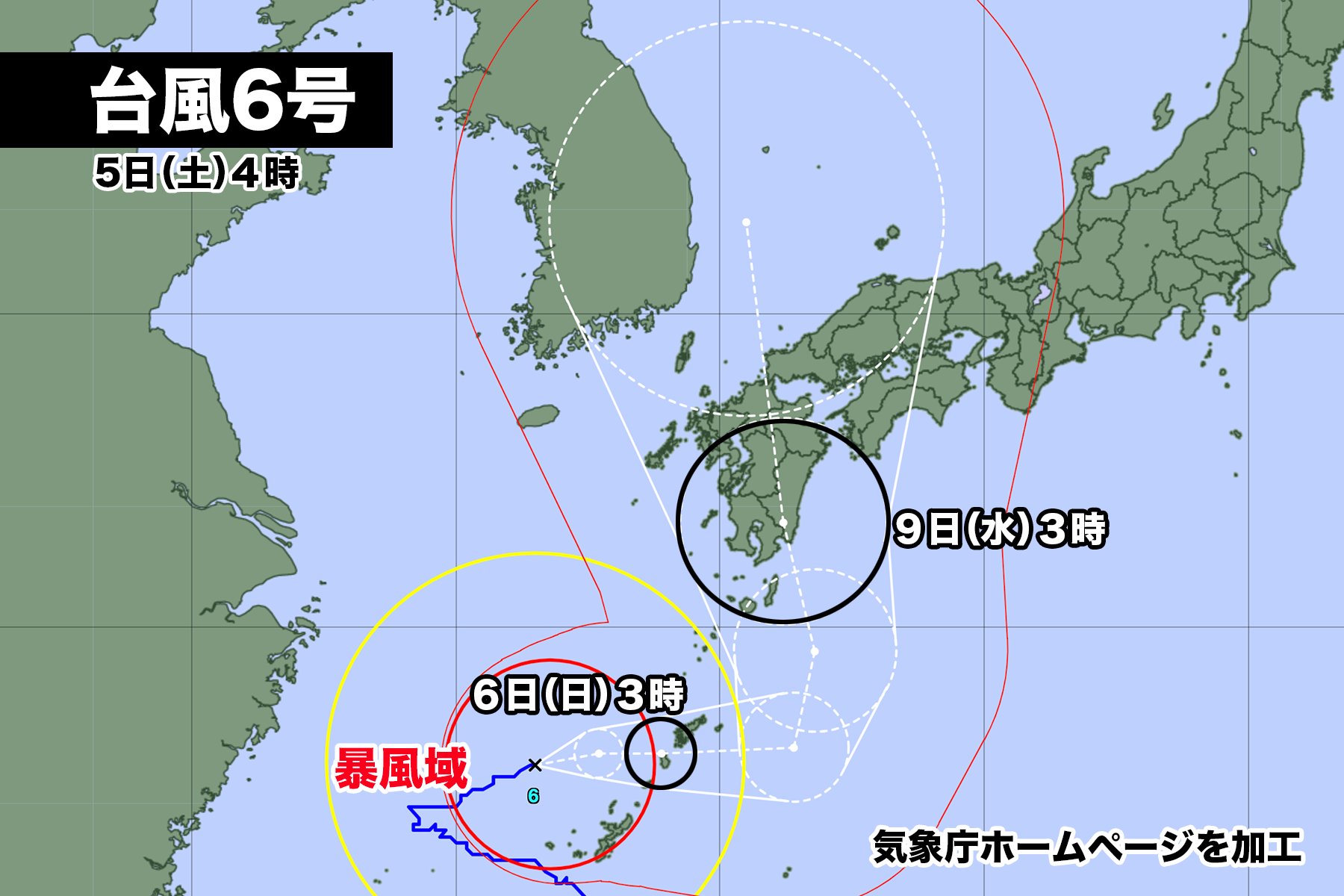

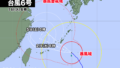
台風6号は東シナ海を東寄りに進んでいる。
午前5時現在、中心気圧は970hPa、中心付近の最大風速は30m/s、最大瞬間風速は45m/ s。奄美地方南部と沖縄本島地方が風速25m/s以上の暴風域に入っている。
勢力はやや衰えたが台風の強さは維持されており、6日日曜日に奄美地方を直撃した後、太平洋上で再び強い勢力に発達する見込みだ。その後、進路を北寄りに変え、9日水曜日は宮崎県か鹿児島県に上陸し、九州を縦断する。台風の動きが遅いため、大雨、暴風、高波などの影響が長引く可能性がある。
【2023年08月05日05時33分 気象庁発表】
沖縄地方や奄美地方では、6日にかけて暴風や高波、高潮、土砂災害、低い土地の浸水、河川の増水や氾濫に厳重に警戒してください。なお、沖縄地方では5日午後から6日午前中にかけて、奄美地方では5日午後から6日日中にかけて、線状降水帯が発生して大雨災害の危険度が急激に高まる可能性があります。
[台風の現況と予想]
台風第6号は、5日4時には久米島の北にあって、1時間におよそ10キロの速さで東北東へ進んでいます。中心の気圧は970ヘクトパスカル、中心付近の最大風速は30メートル、最大瞬間風速は45メートルで、中心の東側220キロ以内と西側165キロ以内では風速25メートル以上の暴風となっています。
台風は、6日にかけて沖縄地方や奄美地方にかなり接近する見込みです。その後、台風は日本の南の海上で勢力を強めて北上し、西日本に接近するおそれがあります。
[防災事項]
<暴風・高波>
沖縄地方では、飛来物によって負傷したり、走行中のトラックが横転するおそれもある猛烈な風が吹いて、猛烈なしけとなっています。奄美地方では非常に強い風が吹いて、大しけとなっています。
沖縄地方や奄美地方では、6日にかけて猛烈な風が吹き、猛烈にしけるでしょう。九州南部でも6日にかけて非常に強い風が吹き、猛烈にしける見込みです。
5日に予想される最大風速(最大瞬間風速)は、
奄美地方、沖縄地方 30メートル(45メートル)
九州南部 20メートル(30メートル)
6日に予想される最大風速(最大瞬間風速)は、
奄美地方、沖縄地方 30メートル(45メートル)
九州南部 24メートル(35メートル)
7日に予想される最大風速(最大瞬間風速)は、
九州南部、奄美地方 25から29メートル(35から45メートル)
の見込みです。
5日に予想される波の高さは、うねりを伴い
奄美地方、沖縄地方 11メートル
九州南部 7メートル
6日に予想される波の高さは、うねりを伴い
奄美地方 11メートル
九州南部、沖縄地方 9メートル
7日に予想される波の高さは、うねりを伴い
九州南部、奄美地方、沖縄地方 9メートルを超える
四国地方、九州北部地方 6から8メートル
の見込みです。
不要不急の外出を控え、屋内では窓から離れるなど暴風に厳重に警戒してください。また、うねりを伴った高波に厳重に警戒してください。
<大雨・雷・突風>
台風本体や周辺の発達した雨雲により、沖縄地方や奄美地方では6日にかけて雷を伴った非常に激しい雨や激しい雨が降り、大雨となる所があるでしょう。
6日6時までの24時間に予想される雨量は、多い所で、
奄美地方、沖縄地方 300ミリ
九州南部 200ミリ
7日6時までの24時間に予想される雨量は、多い所で、
九州南部 200から300ミリ
東海地方、近畿地方、四国地方、奄美地方 100から200ミリ
九州北部地方 100から150ミリ
沖縄地方 50から100ミリ
8日6時までの24時間に予想される雨量は、多い所で、
東海地方、近畿地方、四国地方、九州北部地方、九州南部 200から300ミリ
奄美地方 100から200ミリ
の見込みです。
線状降水帯が発生した場合は、局地的にさらに雨量が増えるおそれがあります。
土砂災害、低い土地の浸水、河川の増水や氾濫に厳重に警戒してください。また、竜巻などの激しい突風や落雷に注意してください。発達した積乱雲の近づく兆しがある場合には、建物内に移動するなど、安全確保に努めてください。
また、西日本から東日本の太平洋側では、台風周辺の湿った空気が流れ込むため、台風が近づく前から雨が降り、南東斜面にあたる地域では総雨量が多くなるおそれがあります。
<高潮>
台風の影響と大潮の時期が重なるため、沖縄地方や奄美地方では潮位が高くなる所があるでしょう。沖縄地方では5日は、奄美地方では6日にかけて、高潮や高潮と重なり合った波浪による浸水に厳重に警戒してください。
Typhoon No. 6 is moving eastward over the East China Sea. As of 5:00 AM, the central pressure is 970 hPa, with maximum sustained winds near the center at 30 m/s and maximum gusts of 45 m/s. The southern parts of the Amami Islands and the Okinawa Main Island region are currently experiencing strong winds exceeding 25 m/s.
Although the typhoon’s intensity has slightly weakened, it remains powerful, and there is a possibility of it intensifying again over the Pacific after directly impacting the Amami Islands on Sunday the 6th. Following that, it is expected to change its course to the north and make landfall in either Miyagi or Kagoshima Prefecture on Wednesday the 9th, traversing Kyushu. Due to the slow movement of the typhoon, the impacts such as heavy rain, strong winds, and high waves may persist for an extended period.
[Announcement by the Japan Meteorological Agency on August 5, 2023, at 5:33 AM]
In the Okinawa and Amami regions, please exercise extreme caution against strong winds, high waves, high tides, mudslides, lowland inundation, and river flooding throughout the day on the 6th. Additionally, be aware that a linear rainband may develop over these regions, rapidly increasing the risk of heavy rainfall disasters during the afternoon of the 5th in Okinawa and from the afternoon to midday on the 6th in the Amami region.
[Typhoon’s Current Status and Forecast]
Typhoon No. 6, as of 4:00 AM on the 5th, was located north of Kume Island, moving at approximately 10 kilometers per hour in the northeast direction. The central pressure is 970 hPa, and within 220 kilometers to the east and 165 kilometers to the west of the center, winds exceeding 25 meters per second are observed, creating violent gusts.
The typhoon is expected to closely approach the Okinawa and Amami regions on the 6th. Afterward, it is projected to strengthen and move northward over the sea south of Japan, with the possibility of approaching western Japan.
[Disaster Preparedness Measures]
<Strong Winds and High Waves>
In the Okinawa region, there are violent winds with the potential to cause injuries from flying objects and overturning of trucks, leading to extremely rough seas. In the Amami region, very strong winds are prevailing, resulting in high waves.
Throughout the day on the 6th, violent winds and very rough seas are expected in the Okinawa and Amami regions. Additionally, on the 6th, very strong winds and very rough seas are anticipated in southern Kyushu.
Expected maximum wind speeds (maximum gusts) on the 5th:
Amami Region, Okinawa Region: 30 meters per second (45 meters per second)
Southern Kyushu: 20 meters per second (30 meters per second)
Expected maximum wind speeds (maximum gusts) on the 6th:
Amami Region, Okinawa Region: 30 meters per second (45 meters per second)
Southern Kyushu: 24 meters per second (35 meters per second)
Expected maximum wind speeds (maximum gusts) on the 7th:
Southern Kyushu, Amami Region: 25 to 29 meters per second (35 to 45 meters per second)
Expected wave heights on the 5th, with swells:
Amami Region, Okinawa Region: 11 meters
Southern Kyushu: 7 meters
Expected wave heights on the 6th, with swells:
Amami Region: 11 meters
Southern Kyushu, Okinawa Region: 9 meters
Expected wave heights on the 7th, with swells:
Southern Kyushu, Amami Region, Okinawa Region: Exceeding 9 meters
Shikoku Region, Northern Kyushu Region: 6 to 8 meters
Please refrain from non-essential outings and take strict precautions against violent winds. Be extra vigilant against high waves with swells.
<Heavy Rain, Thunder, and Squalls>
Due to the typhoon’s core and developing rain clouds in the vicinity, the Okinawa and Amami regions may experience very heavy rain with thunderstorms and intense rainfall throughout the day on the 6th.
Expected rainfall in the 24 hours until 6:00 AM on the 6th:
Amami Region, Okinawa Region: 300 millimeters
Southern Kyushu: 200 millimeters
Expected rainfall in the 24 hours until 6:00 AM on the 7th:
Southern Kyushu: 200 to 300 millimeters
Tokai Region, Kinki Region, Shikoku Region, Amami Region: 100 to 200 millimeters
Northern Kyushu Region: 100 to 150 millimeters
Okinawa Region: 50 to 100 millimeters
Expected rainfall in the 24 hours until 6:00 AM on the 8th:
Tokai Region, Kinki Region, Shikoku Region, Northern Kyushu Region, Southern Kyushu Region: 200 to 300 millimeters
Amami Region: 100 to 200 millimeters
Please be cautious against mudslides, lowland inundation, and river flooding. Pay attention to intense squalls and lightning strikes. If there are signs of developing cumulonimbus clouds, take measures to secure safety, such as moving indoors.
Moreover, as moist air from around the typhoon flows into the Pacific side of western and eastern Japan, rainfall may start before the typhoon approaches, and areas facing the southeast slopes could experience a significant amount of rainfall.
<High Tide>
Due to the overlap of the typhoon’s impact and the period of spring tide, some areas in the Okinawa and Amami regions may experience high tide. On the 5th in Okinawa and on the 6th in the Amami region, please be vigilant against flooding caused by high tides and the combination of high tides with waves.
Stay informed about the latest weather updates and advisories from local authorities and meteorological agencies. Take all necessary precautions to ensure your safety and the safety of others during this typhoon event.
コメント