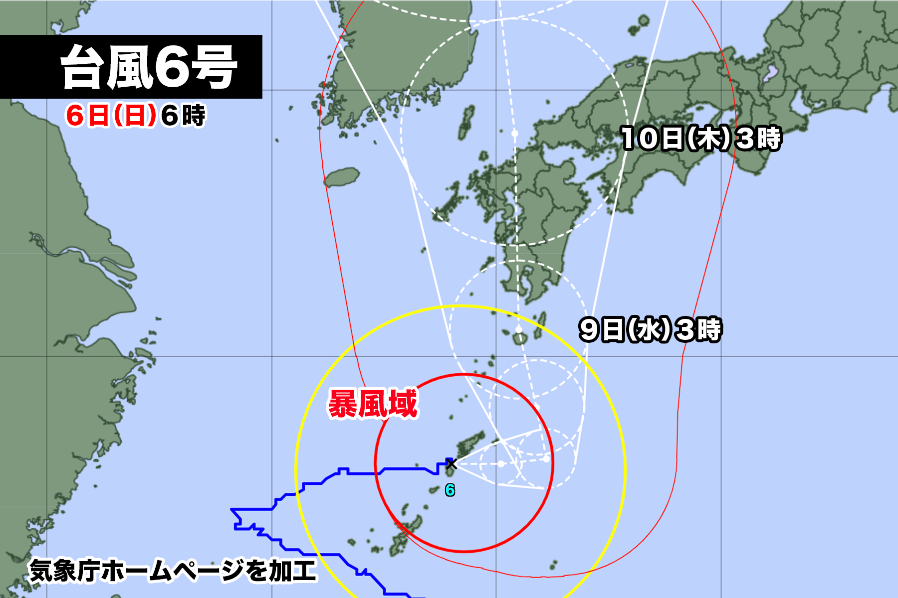
台風6号が鹿児島県徳之島付近を通過中。
午前6時現在中心気圧は970hpa、中心付近の最大風速は30m/s、最大瞬間風速は40m/sで
東にゆっくり進んでいる。奄美地方と沖縄本島の一部が風速25m/s以上の暴風域に入っている。
台風は7日月曜日に進路を直角に北寄りに変えて、九州本土に向かって進む。予報円の中心を進んだ場合、9日水曜日は鹿児島県薩摩半島に上陸、その後、熊本県や福岡県など九州北部地方を縦断して、対馬海峡に進む見込み。台風の動きが遅く、大雨、暴風、高波などの影響が長く続きそうだ。

【2023年08月06日05時21分 気象庁発表】
南西諸島や九州南部では土砂災害、低い土地の浸水、河川の増水や氾濫に厳重に警戒し、南西諸島は暴風や高波に厳重に警戒してください。引き続き、沖縄地方では6日午前中にかけて、奄美地方や九州南部では7日午前中にかけて、線状降水帯が発生して大雨災害の危険度が急激に高まる可能性があります。

[台風の現況と予想]
 台風第6号は、6日4時には徳之島付近にあって、ゆっくりした速さで東へ進んでいます。中心の気圧は970ヘクトパスカル、中心付近の最大風速は30メートル、最大瞬間風速は40メートルで、中心の東側220キロ以内と西側165キロ以内では風速25メートル以上の暴風となっています。
 台風は、奄美地方や沖縄地方にかなり接近しています。6日は東へ進み、その後、日本の南の海上で勢力を強めて北上し、8日以降、西日本にかなり接近するおそれがあります。

[防災事項]
<暴風・高波>
 奄美地方では、飛来物によって負傷したり、走行中のトラックが横転するおそれもある猛烈な風が吹いて、猛烈なしけとなっています。
 奄美地方では、6日は猛烈な風が吹き、猛烈にしけるでしょう。沖縄地方や九州南部では7日にかけて、非常に強い風が吹き、大しけとなる見込みです。

6日に予想される最大風速(最大瞬間風速)は、
奄美地方  30メートル(40メートル)
沖縄地方  25メートル(35メートル)
九州南部  20メートル(30メートル)

7日に予想される最大風速(最大瞬間風速)は、
九州南部、奄美地方  25メートル(35メートル)
沖縄地方  23メートル(35メートル)

8日に予想される最大風速(最大瞬間風速)は、
九州南部、奄美地方  25から29メートル(35から45メートル)
四国地方、九州北部地方 20から24メートル(25から35メートル)
の見込みです。

6日に予想される波の高さは、うねりを伴い
奄美地方 10メートル
九州南部、沖縄地方 8メートル

7日に予想される波の高さは、うねりを伴い
九州南部、奄美地方、沖縄地方  8メートル
四国地方 6メートル

8日に予想される波の高さは、うねりを伴い
九州南部  9メートルを超える
四国地方、九州北部地方、奄美地方、沖縄地方  6から8メートル
の見込みです。

不要不急の外出を控え、屋内では窓から離れるなど暴風に厳重に警戒してください。また、うねりを伴った高波に厳重に警戒してください。

<大雨・雷・突風>
台風本体や周辺の発達した雨雲により、沖縄地方や奄美地方、九州南部では7日にかけて雷を伴った非常に激しい雨や激しい雨が降り、大雨となる所があるでしょう。

7日6時までの24時間に予想される雨量は、多い所で、
九州南部、奄美地方 300ミリ
沖縄地方 250ミリ
四国地方 200ミリ
九州北部地方 150ミリ
東海地方 120ミリ
近畿地方 100ミリ

8日6時までの24時間に予想される雨量は、多い所で、
東海地方、近畿地方、四国地方、九州南部  200から300ミリ
九州北部地方、奄美地方 100から200ミリ
沖縄地方 50から100ミリ

9日6時までの24時間に予想される雨量は、多い所で、
四国地方、九州南部 300から400ミリ
東海地方、近畿地方、九州北部地方 200から300ミリ
奄美地方 100から200ミリ
の見込みです。

線状降水帯が発生した場合は、局地的にさらに雨量が増えるおそれがあります。
土砂災害、低い土地の浸水、河川の増水や氾濫に厳重に警戒してください。また、竜巻などの激しい突風や落雷に注意してください。発達した積乱雲の近づく兆しがある場合には、建物内に移動するなど、安全確保に努めてください。
西日本から東日本の太平洋側では、台風周辺の湿った空気が流れ込むため、台風が近づく前から断続的に非常に激しい雨や激しい雨が降り、南東斜面にあたる地域では総雨量が多くなるおそれがあります。

<高潮>
台風の影響と大潮の時期が重なるため、奄美地方や九州南部では潮位が高くなる所があるでしょう。高潮や高潮と重なり合った波浪による浸水に注意・警戒してください。
Typhoon No. 6 is currently passing near Tokunoshima, Kagoshima Prefecture.
As of 6:00 AM, the central pressure is 970 hPa, and the maximum wind speed near the center is 30 m/s, with maximum gusts of 40 m/s. The typhoon is slowly moving eastward. The Amami region and parts of Okinawa Main Island are experiencing strong winds of 25 m/s or more.
The typhoon is expected to make a right-angle turn to the north on Monday, the 7th, and head towards mainland Kyushu. If it follows the center of the forecasted path, it is projected to make landfall on the Satsuma Peninsula in Kagoshima Prefecture on Wednesday, the 9th. Afterward, it is likely to pass through northern Kyushu, including Kumamoto and Fukuoka Prefectures, and head towards the Tsushima Strait. The typhoon’s slow movement suggests that the impacts, such as heavy rainfall, strong winds, and high waves, may persist for an extended period.
[Announcement from the Japan Meteorological Agency on August 6, 2023, 05:21 AM]
In the Southwest Islands and southern Kyushu, please exercise extreme caution for landslides, flooding in low-lying areas, and increases in river water levels and floods. In the Southwest Islands, be on high alert for strong winds and high waves. Continued vigilance is necessary as a linear rainband is expected to form over the Amami region and southern Kyushu during the morning of the 6th and 7th, respectively, increasing the risk of heavy rain disasters.
[Typhoon Current Status and Forecast]
As of 4:00 AM on the 6th, Typhoon No. 6 is located near Tokunoshima, moving slowly eastward. The central pressure is 970 hPa, with maximum sustained winds near the center reaching 30 meters per second and maximum gusts of 40 meters per second. Winds of 25 meters per second or more are occurring within 220 kilometers to the east and 165 kilometers to the west of the center.
The typhoon is approaching the Amami and Okinawa regions closely. It will continue to move eastward on the 6th, and thereafter, it is expected to strengthen as it moves northward over the waters south of Japan, with a possibility of coming close to western Japan from the 8th onwards.
[Disaster Preparedness]<Strong Winds and High Waves>
In the Amami region, there are violent winds with a risk of injury from flying objects and trucks overturning due to intense winds and high waves.
On the 6th, the Amami region will experience violent winds and extremely rough seas. On the 7th, the Okinawa region and southern Kyushu are expected to have very strong winds and rough seas.
The maximum wind speeds (maximum gusts) expected on the 6th are:
Amami region: 30 meters per second (40 meters per second)
Okinawa region: 25 meters per second (35 meters per second)
Southern Kyushu: 20 meters per second (30 meters per second)
The maximum wind speeds (maximum gusts) expected on the 7th are:
Southern Kyushu, Amami region: 25 meters per second (35 meters per second)
Okinawa region: 23 meters per second (35 meters per second)
The maximum wind speeds (maximum gusts) expected on the 8th are:
Southern Kyushu, Amami region: 25 to 29 meters per second (35 to 45 meters per second)
Shikoku region, northern Kyushu region: 20 to 24 meters per second (25 to 35 meters per second)
The wave heights expected on the 6th, accompanied by swells, are:
Amami region: 10 meters
Southern Kyushu, Okinawa region: 8 meters
The wave heights expected on the 7th, accompanied by swells, are:
Southern Kyushu, Amami region, Okinawa region: 8 meters
Shikoku region: 6 meters
The wave heights expected on the 8th, accompanied by swells, are:
Southern Kyushu: exceeding 9 meters
Shikoku region, northern Kyushu region, Amami region, Okinawa region: 6 to 8 meters
Please refrain from unnecessary outdoor activities and take precautions against violent winds. Also, be vigilant against high waves accompanied by swells.
<Heavy Rain, Thunderstorms, and Squalls>
Due to the main body of the typhoon and the development of rain clouds in the vicinity, there may be very heavy rain and intense rainfall with thunder in the Okinawa region, Amami region, and southern Kyushu on the 7th.
The expected 24-hour rainfall until 6:00 AM on the 7th is as follows:
Southern Kyushu, Amami region: 300 mm
Okinawa region: 250 mm
Shikoku region: 200 mm
Northern Kyushu region: 150 mm
Tokai region: 120 mm
Kinki region: 100 mm
The expected 24-hour rainfall until 6:00 AM on the 8th is as follows:
Tokai region, Kinki region, Shikoku region, southern Kyushu: 200 to 300 mm
Northern Kyushu region, Amami region: 100 to 200 mm
Okinawa region: 50 to 100 mm
The expected 24-hour rainfall until 6:00 AM on the 9th is as follows:
Shikoku region, southern Kyushu: 300 to 400 mm
Tokai region, Kinki region, northern Kyushu region: 200 to 300 mm
Amami region: 100 to 200 mm
In the event of a linear rainband, there is a possibility of localized additional rainfall. Please exercise extreme caution against landslides, flooding in low-lying areas, and increases in river water levels and floods. Also, be alert for severe gusts such as tornadoes and lightning. If there are signs of developing cumulonimbus clouds, seek shelter indoors to ensure safety.
In western Japan to the Pacific side of eastern Japan, moist air around the typhoon may cause intermittent and heavy rain even before the typhoon approaches, resulting in a significant amount of rainfall on southeast-facing slopes.
<High Tide>
Due to the combined influence of the typhoon and the spring tide, there may be higher-than-normal tidal levels in the Amami region and southern Kyushu. Please be cautious and vigilant against flooding caused by high tides and wave surges,
コメント