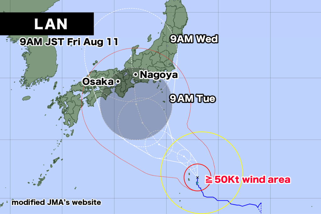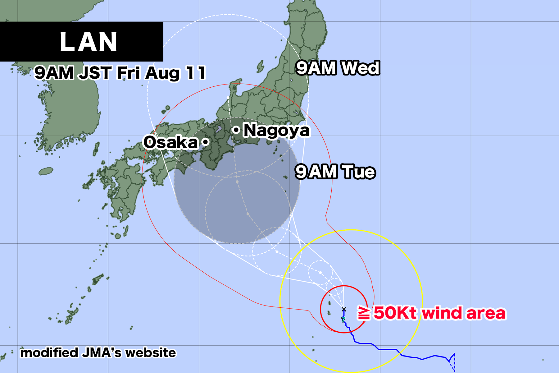
As of 9:00 AM on Friday the 11th, Typhoon LAN, an extremely strong typhoon, is slowly moving northward over the sea approximately 90 kilometers southeast of Chichi-jima Island. The central pressure is 940 hectopascals, the maximum sustained wind speed near the center is 45 meters per second, and the maximum gust speed is 65 meters per second. Within a radius of 130 kilometers from the center, there is an area of storm-force winds with speeds exceeding 25 meters per second.
The typhoon is expected to continue moving northward while intensifying. There is a possibility that by next Tuesday the 15th, it could directly hit the Tokai region with strong force. As of now, the forecast cone indicating the area where the center of the typhoon has a 70% probability of entering is relatively wide, as the typhoon’s future track has not been precisely determined. Therefore, it is important to be aware that it could come quite close not only to the Tokai region but also to the Shikoku and Kinki regions.
Satellite imagery shows that the cloud cover around the typhoon is compact, and the eye of the typhoon is clearly visible. This is indicative of its strong intensity, and the clouds of the typhoon are expected to maintain their circular pattern as they move northward. Another distinctive feature is the linear cloud band extending eastward from the tropical region on the eastern side of the typhoon.
【August 11, 2023, 05:25 AM JST, Japan Meteorological Agency Announcement】
Typhoon LAN, an extremely strong typhoon, is expected to come closest to Ogasawara Islands during the evening of the 11th. In the Ogasawara Islands, please exercise extreme caution for stormy winds, high waves, tidal surges, and potential landslides.
【Current Conditions and Forecast of the Typhoon】
As of 4:00 AM on the 11th, Typhoon LAN was located southeast of Chichi-jima Island, moving at a speed of approximately 10 kilometers per hour towards the north-northwest. The central pressure is 950 hectopascals, the maximum sustained wind speed near the center is 45 meters per second, and the maximum gust speed is 60 meters per second. Within a radius of 130 kilometers from the center, there is an area of storm-force winds with speeds exceeding 25 meters per second. The typhoon is expected to continue developing while moving northward within its stormy area. It is expected to come closest to the Ogasawara Islands during the evening of the 11th. Afterwards, the typhoon is anticipated to continue moving northwestward over southern Japan, maintaining strong force, and there is a possibility of approaching eastern and western Japan around the 15th. Rough and stormy weather conditions may be expected in eastern and western Japan starting around the 14th.
【Disaster Prevention Measures】
<Stormy Winds and High Waves>
In the Ogasawara Islands on the 12th, there is a risk of violent winds that could potentially cause partial house collapses, along with stormy waves and swells. In the Izu Islands, rough seas with swells are expected on the 12th, followed by very strong winds and stormy waves with swells on the 13th. Additionally, in the Kanto and Tokai regions on the 13th, rough seas with swells are anticipated.
The expected maximum wind speeds (maximum gust speeds)
On the 11th are:
Ogasawara Islands: 45 meters per second (65 meters per second)
On the 12th:
Ogasawara Islands: 30 meters per second (45 meters per second)
On the 13th:
Izu Islands:25 to 29 meters per second (35 to 45 meters per second)
The expected wave heights on the 11th, accompanied by swells, are:
Ogasawara Islands: 9 meters
On the 12th:
Ogasawara Islands: 9 meters
Izu Islands: 7 meters
On the 13th:
Izu Islands: exceeding 9 meters
Kanto region, Tokai region, Ogasawara Islands: 6 to 8 meters
In the Ogasawara Islands, please avoid unnecessary outdoor activities and exercise extreme caution against stormy winds by staying away from windows indoors. In the Ogasawara and Izu Islands, please be vigilant against high waves. In the Kanto and Tokai regions, please be cautious of high waves.
<Heavy Rainfall>
In the Ogasawara Islands, on the 12th, very heavy rain accompanied by thunderstorms and intense rainfall is expected, leading to heavy rainfall. Moreover, in the Izu Islands on the 13th, there is a risk of heavy rain due to the typhoon’s influence. The estimated rainfall in the 24 hours until 6:00 AM on the 12th is expected to be significant in some areas: Ogasawara Islands: 200 millimeters
In the Ogasawara Islands, please exercise caution against landslides, lowland flooding, and rising river levels.
<High Tides>
In the Ogasawara Islands on the 11th, tides are expected to rise due to the approaching typhoon. Please exercise extreme caution against flooding caused by high tides and the overlap of high tides with waves.


コメント