
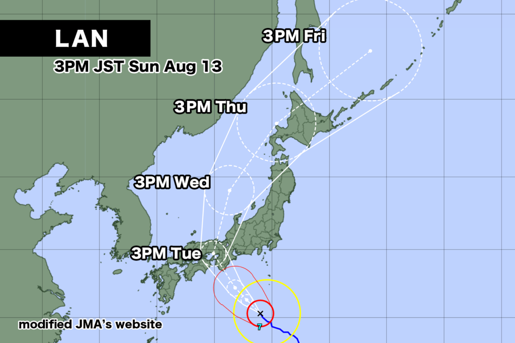
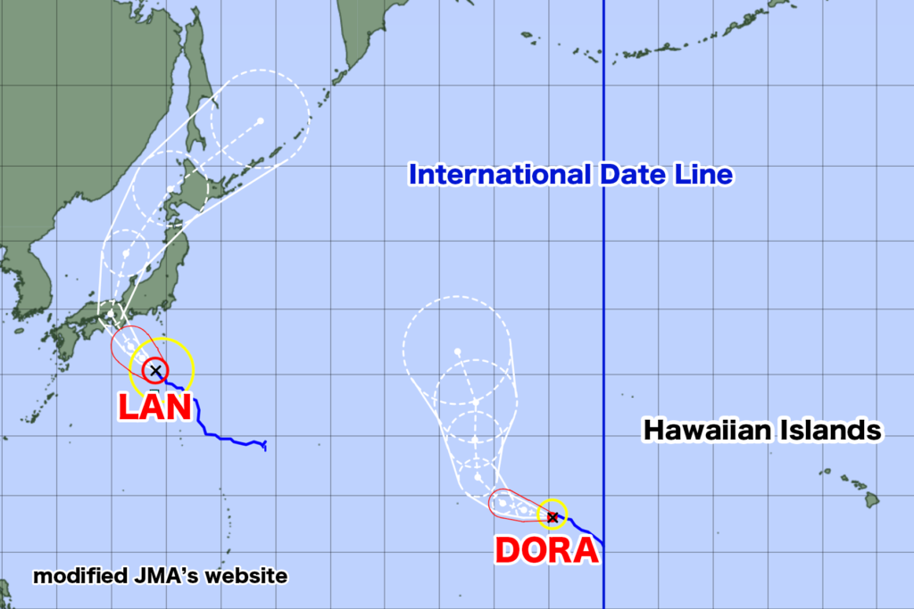
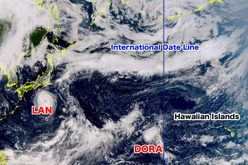
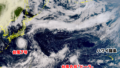
As of 3:00 PM on Sunday the 13th, Powerful Typhoon LAN is moving northwest at a speed of 15 km/h south of Hachijojima. The central pressure is 965 hPa, with maximum sustained winds near the center reaching 40 m/s and maximum gusts of 55 m/s, accompanied by a storm zone with winds exceeding 25 m/s.

Although the peak intensity has passed, the typhoon is expected to continue moving northward with strong force until Monday the 14th. The forecast cone has narrowed, and the trajectory has become more defined. If the center follows the forecast cone, there is a high possibility of the typhoon making landfall on the Kii Peninsula on the morning of the 15th, directly hitting Hyogo and Osaka in the afternoon. Osaka and Kyoto will fall under the dangerous right side of the typhoon's path, with a significant risk of strong winds.

Afterward, the typhoon is projected to move into the Sea of Japan and pass near Hokkaido on Thursday the 17th, transitioning into an extratropical cyclone over the Sea of Okhotsk on Friday the 18th.

In addition, Hurricane "Dora," which contributed to the massive wildfire on Maui Island in Hawaii, crossed the International Date Line and became Typhoon 8 at 9:00 AM on the 13th. The wildfire on Maui Island has claimed approximately 90 lives, marking the worst devastation in over a century in the United States. While Hurricane "Dora" did not directly hit Hawaii, its strong easterly winds influenced the wildfire's spread on Maui Island. Currently, the likelihood of Typhoon 8 affecting Japan is low.

The occurrence of a hurricane crossing the International Date Line and becoming a typhoon is the first time since Typhoon 17 "Hector" in 2018, a gap of five years.
【Announcement from the Japan Meteorological Agency - August 13, 05:45】

Typhoon LAN, a powerful one, is expected to come quite close to eastern and western Japan on the 15th, with a possibility of making landfall. In these regions, precautions should be taken against strong winds, landslides, flooding of low-lying areas, river inundation, and high waves.

【Current Situation and Forecast of the Typhoon】
As of 3:00 PM on the 13th, Typhoon LAN is located to the northwest of Hachijo Island, moving at a slow pace to the northwest. The central pressure is 965 hPa, with maximum sustained winds of 40 meters per second near the center and maximum wind gusts of 55 meters per second. Areas with wind speeds exceeding 25 meters per second are within a radius of 95 kilometers from the center. The typhoon is expected to continue moving northward over southern Japan and come close to eastern and western Japan on the 15th. After that, it is anticipated to move into the Sea of Japan on the 16th.

【Disaster Prevention Measures】
<Strong Winds and High Waves>
In the Izu Islands, very strong winds are expected on the 14th, accompanied by rough seas with swells on the 15th. On the 15th, extremely strong winds are anticipated for the Pacific side of eastern and western Japan. From the 14th to the 15th, Kyushu, Shikoku, and the Kanto regions are forecasted to experience severe winds, while Kinki region will encounter violent winds, followed by rough seas on the 15th.

The maximum wind speeds (maximum gusts) expected on the 13th are:
Izu Islands: 20 meters per second (30 meters per second)
On the 14th:
Tokai region: 30 meters per second (40 meters per second)
Kinki and Shikoku regions: 23 meters per second (35 meters per second)
Izu Islands: 20 meters per second (30 meters per second)
On the 15th:
Tokai and Kinki regions: 30 to 40 meters per second (40 to 60 meters per second)
Shikoku region: 20 to 24 meters per second (25 to 35 meters per second)

【Prediction of Wave Heights】
On the 13th:
Izu Islands: 8 meters (with swells)
Ogasawara Islands, Tokai region, Kinki region: 6 meters
On the 14th:
Izu Islands, Tokai region, Kinki region: 8 meters (with swells)
Shikoku region: 7 meters
Kanto region: 6 meters
On the 15th:
Kanto, Izu Islands, Tokai region, Kinki region, Shikoku region: 6 to 8 meters

Precautions against strong winds should be taken in the Tokai and Kinki regions, while vigilance against high waves is advised from eastern to western Japan's Pacific coast.

<Heavy Rain, Lightning, and Gusts>
From the 14th to the 15th, heavy rain accompanied by thunder and very heavy rain are expected in eastern Japan, with similar conditions forecast for western Japan. Particularly, the Pacific side of both regions may experience intense rainfall and downpours.

The expected rainfall within 24 hours until the 15th at 6:00 AM is as follows:
Tokai region: 300 to 500 millimeters
Kanto-Koshin region, Kinki region: 200 to 300 millimeters
Shikoku region: 100 to 200 millimeters
Until the 16th at 6:00 AM:
Tokai region: 300 to 400 millimeters
Kanto-Koshin region, Kinki region, Shikoku region: 200 to 300 millimeters

Please remain cautious of mudslides, flooding of low-lying areas, river inundation, and high waves. Additionally, pay attention to severe gusts like lightning and tornadoes. If there are signs of developing cumulonimbus clouds, seek shelter indoors to ensure safety.

<High Tides>
Due to the typhoon's influence, elevated tide levels may occur in eastern and western Japan. Please exercise caution and vigilance against flooding caused by high tides and the combination of high tides with wave surges.
コメント