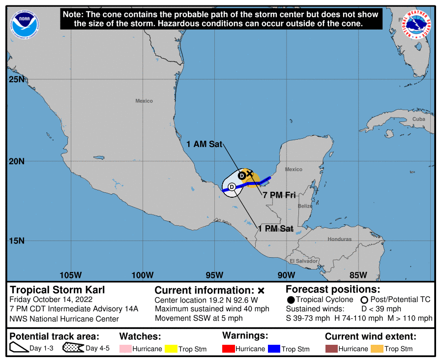
熱帯低気圧カール(Karl)がメキシコにかなり接近している。

14日金曜日・現地時間午後7時、カールはメキシコ・ユカタン半島の西にあり、1時間に約7キロのゆっくりしたスピードで南南西に進んでいる。
土曜日は南南西または南西へと進み、メキシコ湾の最南端カンペチェ湾に達して、メキシコの沿岸部にかなり接近する見込み。カールは今後、次第に勢力を弱め、日曜日の初めごろまでには消滅する。
現在、最大風速は18m/sで強い突風を伴っている。強い風の範囲は、中心から最大で110km外側に広がっていて、中心気圧は1003ヘクトパスカルと想定される。

ーーー陸地への影響
・日曜日の早朝までに、メキシコのベラクルス州、タバスコ州、チアパス州とオアハカ州の北部で、50ミリから約130ミリの雨が予想され、多いところでは200ミリに達する見込み。標高が高いところでは土砂崩れや鉄砲水が発生する恐れ
・土曜日の夜は警戒区域で熱帯低気圧クラスの暴風雨となり、特に突風に要警戒
・土曜日の夜にかけてメキシコ沿岸部に高いうねりが打ち寄せる。人命に関わるレベルの高波とリップカレントが発生する恐れ
At 700 PM CDT (0000 UTC), the center of Tropical Storm Karl was located near latitude 19.2 North, longitude 92.6 West. Karl is moving toward the south-southwest near 5 mph (7 km/h).
A south southwestward or southwestward motion is expected during the next day or so as Karl moves over the Bay of Campeche. On the forecast track, the center of Karl should be near the coast of southern Mexico on Saturday.
Maximum sustained winds are near 40 mph (65 km/h) with higher gusts. Gradual weakening is forecast, and Karl is expected to become a tropical depression tonight or early Saturday and dissipate by early Sunday.
Tropical-storm-force winds extend outward up to 70 miles (110 km) from the center. The estimated minimum central pressure is 1003 mb (29.62 inches).
HAZARDS AFFECTING LAND
RAINFALL: Karl is expected to produce 2 to 5 inches of rain, with local maxima up to 8 inches, across portions of Veracruz, Tabasco, and northern Chiapas and Oaxaca states in Mexico into early Sunday. These rains could produce flash flooding, along with mudslides, in
higher terrain.
WIND: Tropical storm conditions, especially in gusts, are expected within portions of the tropical storm warning area this evening.
SURF: Swells generated by Karl are expected to affect the Mexican coastline through Saturday night. These swells are likely to cause life-threatening surf and rip current conditions.

コメント