
・コースがやや西寄りに変化
・28日水曜日に強い勢力で西日本を直撃
・進行スピードが遅く、影響が長引く恐れ
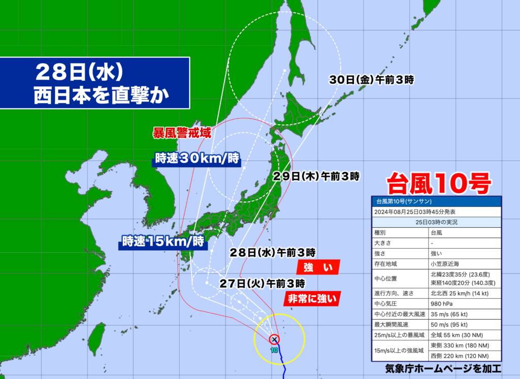
日曜日午前5時現在、強い台風10号は小笠原近海にあって、時速約25キロで北北西に進んでいる。中心気圧は980ヘクトパスカル、中心付近の最大風速は35メートル、最大瞬間風速は50メートルで暴風域を伴っている。
台風の北上傾向は変わらないが、コースがやや西寄りに変化を見せている。太平洋高気圧の西への張り出しによるものとみられ、予報円の中心を進んだ場合、28日(水)の午前中に四国あるいは紀伊半島に上陸する可能性が高い。台風の中心が70%の確率で入るとされる予報円が小さくなってきたので、コースも徐々に定まってきているようだ。
27日(火)は非常に強い勢力になり、上陸の可能性がある28日(水)は強い勢力が予想されている。水曜日の段階で台風の進行スピードは15キロ。かなりゆっくりなスピードで、西日本を縦断して日本海に抜けるまで、大雨、暴風、高波などの影響が長引く恐れがある。
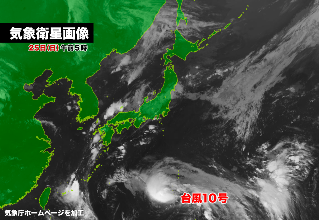
台風10号の気象衛生画像では、まだ雲が同心円状ではなく、発達途中の過程であることがわかる。予想進路のエリアでは海水温がかなり高く、今後、急速に発達、勢力のピークを迎える見込みの27日(火)には台風の目がしっかり見えてくるはずだ。なお、ピーク時の中心気圧は950ヘクトパスカル、最大瞬間風速は60メートルが予想されている。
As of 5:00 AM on Sunday, a powerful Typhoon No. 10 is positioned near the Ogasawara Islands, moving north-northwest at a speed of approximately 25 km/h. The central pressure is 980 hPa, with maximum sustained winds of 35 m/s near the center and gusts up to 50 m/s, creating a wide area of storm-force winds.
The typhoon continues to move northward, but its course has shifted slightly westward. This change is believed to be due to the expansion of the Pacific high-pressure system to the west. If the typhoon follows the center of the projected path, there is a high likelihood it will make landfall on Shikoku or the Kii Peninsula on the morning of Wednesday, the 28th. The forecast cone, which represents a 70% probability of where the typhoon’s center will be, has narrowed, indicating that the course is becoming more predictable.
By Tuesday, the 27th, the typhoon is expected to intensify significantly, and by the time it potentially makes landfall on Wednesday, the 28th, it is forecasted to maintain strong intensity. The typhoon’s forward speed is expected to slow to 15 km/h by Wednesday, meaning it could move slowly across western Japan. As it traverses the region and eventually moves into the Sea of Japan, the prolonged impact of heavy rain, strong winds, and high waves could pose significant risks.
Satellite imagery of Typhoon No. 10 reveals that the clouds are not yet forming concentric circles, indicating that the typhoon is still in its developmental stages. In the projected path area, sea surface temperatures are quite high, which is expected to fuel rapid intensification. By Tuesday, the 27th, when the typhoon is forecasted to reach its peak intensity, a well-defined eye is likely to become visible. At its peak, the central pressure is expected to drop to 950 hPa, with maximum gusts reaching 60 m/s.

コメント