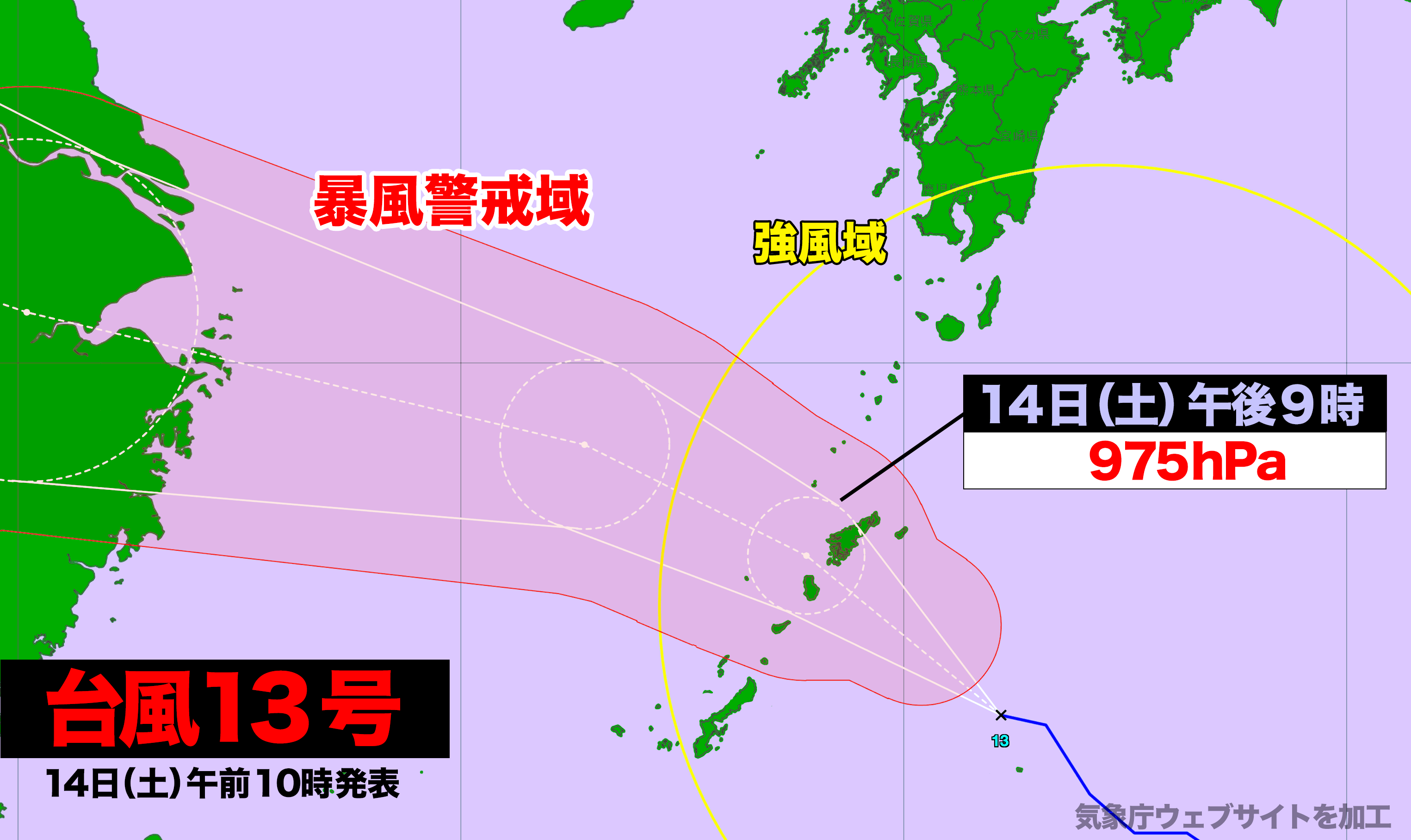

台風13号が奄美地方に接近中だ。
14日(土)午前10時現在、台風は九州南部と沖縄本島地方を風速15メートル以上の強風域に巻き込みながら西北西に進んでいる。土曜日の夕方には奄美地方は風速25メートル以上の暴風域に入る見込みで、猛烈な風、大しけ、大雨による被害が発生するリスクが高まる見込み。レーダー画像にも台風の雨雲がはっきりと見えてきた。
【気象情報 名瀬測候所発表 14日(土)午前11時】
台風第13号は、14日10時には南大東島の北約80キロにあって、1時間におよそ30キロの速さで北西へ進んでいます。
今後、台風は発達しながら北西へ進み、14日夕方から14日夜のはじめ頃にかけて、暴風域を伴って奄美地方にかなり接近する見込みです。奄美地方では全域が風速15メートル以上の強風域に入っており、台風が予報円の中心付近を進んだ場合、早い所では14日夕方から風速25メートル以上の暴風域に入るでしょう。
このため、奄美地方では15日未明にかけて非常に強い風が吹き、北部と南部では14日夕方から14日夜のはじめ頃にかけて、飛来物によって負傷したり、走行中のトラックが横転するおそれもある猛烈な風が吹く見込みです。
奄美地方の沿岸の海域では、15日明け方にかけてうねりを伴った大しけとなるでしょう。
奄美地方では、台風周辺や台風本体の暖かく湿った空気が流れ込み大気の状態が非常に不安定となっています。このため、奄美地方では15日未明にかけて断続的に激しい雨が降るでしょう。特に北部と南部では、14日夕方から14日夜のはじめ頃にかけて非常に激しい雨が降り、大雨となるおそれがあります。また、奄美地方では落雷や竜巻などの激しい突風のおそれもあります。
北部と南部では、台風の接近に伴い14日夕方から14日夜のはじめ頃にかけて潮位が高くなり、沿岸や河口付近の低地では浸水や冠水のおそれがあります。
[強風域入等のタイミング]
(予報円の中心を通った場合:14日9時現在)
強風域入 暴風域入 最接近
北部 14日0時頃 14日夕方 14日夜のはじめ頃
南部 14日3時頃 14日夕方 14日夜のはじめ頃
十島村 14日6時頃 予想なし 14日夜のはじめ頃
[風の予想]
14日に予想される最大風速(最大瞬間風速)
北部 30メートル (45メートル)
南部 30メートル (45メートル)
十島村 23メートル (35メートル)
15日に予想される最大風速(最大瞬間風速)
北部 23メートル (35メートル)
南部 23メートル (35メートル)
十島村 20メートル (30メートル)
[波の予想]
14日に予想される波の高さ
北部 8メートル うねりを伴う
南部 8メートル うねりを伴う
十島村 8メートル うねりを伴う
15日に予想される波の高さ
北部 6メートル うねりを伴う
南部 6メートル うねりを伴う
十島村 6メートル うねりを伴う
[雨の予想]
14日に予想される1時間降水量は多い所で、
北部 50ミリ
南部 50ミリ
十島村 30ミリ
15日に予想される1時間降水量は多い所で、
北部 30ミリ
南部 30ミリ
十島村 30ミリ
14日12時から15日12時までに予想される24時間降水量は多い所で、
北部 150ミリ
南部 150ミリ
十島村 100ミリ
[潮位の予想]
14日に予想される最高潮位
北部 標高 1.5メートル
南部 標高 1.5メートル
[防災事項]
厳重警戒:暴風
警戒事項:うねりを伴った高波、土砂災害、低い土地の浸水、河川の増水や氾濫
注意事項:高潮、落雷、竜巻などの激しい突風
不要不急の外出を控え、屋内では窓から離れるなど暴風に厳重に警戒してください。
発達した積乱雲の近づく兆しがある場合には、建物内に移動するなど、安全確保に努めてください。
◆マンガ読み放題 単行本3万冊以上【BOOK☆WALKER】
【広告】東大生の2人に1人が受講経験(小学講座)がある通信教育
・利用者数No.1 進研ゼミ 小学講座
・部活と両立して得点UP 中学講座
・塾に通わず大学に現役合格 高校講座
Typhoon No. 13 Approaches the Amami Region
As of 10 a.m. on Saturday, September 14, Typhoon No. 13 continues to move west-northwest, affecting southern Kyushu and the Okinawa mainland with winds exceeding 15 meters per second. By Saturday evening, the Amami region is expected to enter a zone of violent winds, with speeds surpassing 25 meters per second. The risk of severe damage from strong winds, rough seas, and heavy rainfall is increasing. Radar imagery now clearly shows rain clouds associated with the typhoon.
Weather Advisory from Naze Meteorological Office, Issued at 11 a.m. on Saturday, September 14
As of 10 a.m. on September 14, Typhoon No. 13 was located approximately 80 kilometers north of Minami-Daito Island, moving northwest at a speed of about 30 kilometers per hour.
The typhoon is expected to intensify as it continues to move northwest, nearing the Amami region between the evening and early night of September 14. The entire Amami region is already experiencing strong winds of over 15 meters per second. If the typhoon follows the central path of the forecast cone, some areas could enter a zone of violent winds exceeding 25 meters per second as early as this evening.
As a result, the Amami region is expected to experience very strong winds until the early morning of September 15. In the northern and southern areas, severe gusts could cause flying debris, posing a risk of injury, and there is a possibility of trucks overturning while in transit due to the powerful winds expected from the evening to early night of September 14.
Coastal areas of the Amami region will see rough seas with large swells, which will persist until the early morning of September 15.
The influx of warm, moist air from around the typhoon has destabilized the atmosphere over the Amami region, leading to continuous heavy rainfall expected until the early morning of September 15. The northern and southern areas, in particular, may experience very heavy rainfall from the evening to early night of September 14, raising concerns about potential flooding. There is also a risk of lightning strikes, tornadoes, and sudden strong gusts.
In addition, tidal levels in the northern and southern areas are expected to rise with the approach of the typhoon, particularly from the evening to early night of September 14, increasing the risk of flooding in coastal and river mouth areas.

コメント