

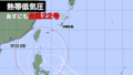
フィリピンの一部が風速15メートル以上の強風域に入ってきた。
28日午前6時現在、台風22号はフィリピンの東を1時間に15キロの速さで西に進んでいる。中心気圧は996ヘクトパスカル。
台風はこの後、発達しながら西に進む見込みで、日曜日にフィリピンに上陸、月曜日に南シナ海に進む。台風の接近でフィリピンでは大雨や暴風、高潮の被害が出る恐れがある。
その後、台風は北上し、来週後半は台湾でも大荒れの天気になる可能性が出てきた。
A part of the Philippines entered a strong wind area with a wind speed of 15m/s or more.
As of 6:00 am on the 28th, Typhoon No. 22 is moving westward east of the Philippines at a speed of 15km/h. The central atmospheric pressure is 996hPa.
The typhoon is expected to intensify and move west, making landfall in the Philippines on Sunday and moving into the South China Sea on Monday. It could cause heavy rains, wind storm and storm surges in the Philippines.
After that, the typhoon will move northward, and there is a possibility that Taiwan will also experience severe weather in the second half of next week.

コメント