


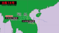
【5日金曜日午前7時】
4日未明に発生した台風15号は発達しながら鹿児島県と宮崎県の東を北上し、5日午前1時頃に高知県宿毛市付近に上陸しました。現在は室戸市付近を時速25キロで東北東に進んでいます。
台風はこのあと、ほぼ勢力を維持しながら東寄りに進み5日午後6時に伊豆大島付近、7日日曜日午前3時に日本のはるか東海上で温帯低気圧に変わる見込みです。
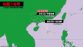
台風の接近に伴い、近畿、東海、関東には発達した雨雲がかかっていて、気象庁は茨城県、埼玉県、千葉県、東京地方、神奈川県、山梨県、長野県、伊豆諸島では5日昼前から5日夜のはじめ頃にかけて、線状降水帯が発生して大雨災害発生の危険度が急激に高まる可能性があると警戒を呼びかけています。
[7:00 a.m. Friday, September 5]
Typhoon No. 15(Peipah), which formed in the early hours of Thursday, continued to intensify as it tracked northward east of Kagoshima and Miyazaki prefectures, making landfall near Sukumo City, Kochi Prefecture, around 1:00 a.m. Friday. It is currently moving east-northeast at a speed of 25 kilometers per hour near Muroto City.
The typhoon is expected to maintain much of its strength as it moves eastward, passing near Izu Oshima around 6:00 p.m. Friday, before transitioning into an extratropical cyclone over the far eastern waters of Japan by 3:00 a.m. Sunday, September 7.
As the storm approaches, developed rainbands are spreading across the Kinki, Tokai, and Kanto regions. The Japan Meteorological Agency has issued warnings that in Ibaraki, Saitama, Chiba, the Tokyo metropolitan area, Kanagawa, Yamanashi, Nagano, and the Izu Islands, linear precipitation systems may form from late Friday morning through early Friday night, sharply increasing the risk of serious flooding and landslides.
コメント