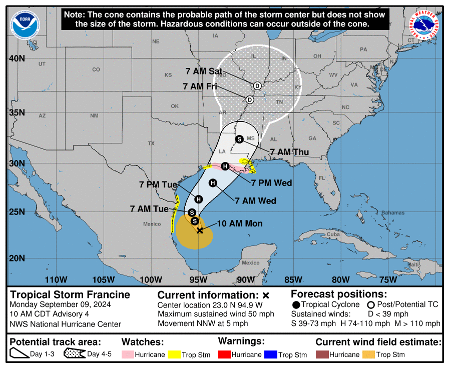
9月9日(月)午前10時(アメリカ中部夏時間、日本時間10日(火)午前0時)、熱帯低気圧フランシーヌの中心はメキシコ湾の北緯23.0度、西経94.9度付近にあり、時速5マイル(時速7キロ)で北北西に進んでいる。このまま日中はゆっくりと北北西に進み、火曜日には速度を上げて北東に進む予想。予想進路では、火曜日までメキシコ北部の沖合にほぼ停滞し、水曜日にはルイジアナ州およびテキサス州の海岸線に達する見通し。
最大風速は50マイル(約24m/s)で、さらに強い突風が吹くことが予想される。火曜日は徐々に勢力が強まり、火曜日の夜から水曜日にかけて大幅に勢力が増す。水曜日にルイジアナ州などメキシコ湾北西部の海岸に達する見込みだが、その前にハリケーンに成長する。
現在、フランシーヌに伴う強風域は中心から最大160マイル(約260キロ)にわたって広がっており、中心気圧は1002hPa(29.59インチ)。
陸地への影響
【強風、暴風】
水曜日の朝までに熱帯低気圧級の暴風が吹く可能性がある。また水曜日の午後にはハリケーン級の暴風が注意報地域で吹く恐れ。
【大雨、洪水】
メキシコ北東部沿岸からテキサス州南部沿岸、さらにテキサス州上部、ルイジアナ州南部およびミシシッピ州南部にかけて、木曜日の朝までに総雨量4~8インチ(約100~200ミリ)、局地的には最大12インチ(約300ミリ)の雨が予想される。この雨で都市部などで洪水のリスクが急激に高まる恐れがある。
【高波、高潮】
高潮と満潮が重なることで、通常は乾燥している沿岸部の地域が水没する恐れがある。予想される水位は以下のとおり。
・ルイジアナ州キャメロンからポート・フーションまで:5~10フィート(約1.5〜3メートル)
・バーミリオン湾:5〜10フィート(約1.5〜3メートル)
・ルイジアナ州ポート・フーションからミシシッピ川河口まで:4〜7フィート(約1.2〜2メートル)
・テキサス州ハイアイランドからルイジアナ州キャメロンまで:3〜5フィート(約90センチ〜1.5メートル)
最も水位が高くなるのは上陸地点の直近および東側の沿岸部で、危険な高波を伴う。高潮による洪水の影響の度合いは場所によって大きく異なることに留意。リスク軽減のために設置されている堤防は特に問題ないと思われるが、地元にある堤防では一部で越水する可能性がある。メキシコ沿岸でも、風向きによっては軽度の沿岸洪水が発生する。
【うねり、離岸流】
熱帯低気圧フランシーヌによる海上のうねりは、すでにメキシコ湾岸の一部に達しており、週の中頃までにメキシコ北西部の海岸に広がる予想。人命を脅かすほどの高波や離岸流が発生する可能性が高い。
At 1000 AM CDT (1500 UTC), the center of Tropical Storm Francine was
located near latitude 23.0 North, longitude 94.9 West. Francine is
moving toward the north-northwest near 5 mph (7 km/h) and a slow
north-northwestward motion is expected for the remainder of the day,
followed by a faster motion to the northeast beginning on Tuesday.
On the forecast track, Francine is expected to be just offshore of
the northern Gulf Coast of Mexico through Tuesday, and approach the
Louisiana and Upper Texas coastline on Wednesday.
Maximum sustained winds remain near 50 mph (85 km/h) with higher
gusts. Gradual intensification is expected over the next day with
more significant intensification on Tuesday Night and Wednesday.
Francine is expected to become a hurricane before it reaches the
northwestern U.S. Gulf Coast on Wednesday.
Tropical-storm-force winds extend outward up to 160 miles (260 km)
from the center.
The estimated minimum central pressure is 1002 mb (29.59 inches).
Key messages for Tropical Storm Francine can be found in the
Tropical Cyclone Discussion under AWIPS header MIATCDAT1 and WMO
header WTNT41 KNHC.
WIND: Hurricane conditions are possible within the watch area by
Wednesday afternoon, with tropical storm conditions possible by
Wednesday morning.
Tropical storm conditions are possible within the watch area along
the northern coast of Mexico and extreme southern Texas beginning
Tuesday, and for the extreme northern Texas and portions of the
Louisiana coast on Wednesday.
RAINFALL: Tropical Storm Francine is expected to bring storm
total rainfall of 4 to 8 inches, with local amounts to 12 inches,
from the coast of far northeast Mexico northward along portions of
the southern Texas coast, the far upper Texas coast and across
southern Louisiana and southern Mississippi into Thursday morning.
This rainfall could lead to the risk of considerable flash and urban
flooding.
For a complete depiction of forecast rainfall associated with
Tropical Storm Francine, please see the National Weather
Service Storm Total Rainfall Graphic, available at
hurricanes.gov/graphics_at1.shtml?rainqpf and the Flash Flood Risk
graphic at hurricanes.gov/graphics_at1.shtml?ero.
STORM SURGE: The combination of a dangerous storm surge and the
tide will cause normally dry areas near the coast to be flooded by
rising waters moving inland from the shoreline. The water could
reach the following heights above ground somewhere in the indicated
areas if the peak surge occurs at the time of high tide…
Cameron, LA to Port Fourchon, LA…5-10 ft
Vermilion Bay…5-10 ft
Port Fourchon, LA to Mouth of the Mississippi River, LA…4-7 ft
High Island, TX to Cameron, LA…3-5 ft
The deepest water will occur along the immediate coast near and to
the east of the landfall location, where the surge will be
accompanied by large and dangerous waves. Surge-related flooding
depends on the relative timing of the surge and the tidal cycle, and
can vary greatly over short distances. Storm surge is not expected
to pose a threat to the risk reduction system levees. However, there
may be some overtopping of local levees. For information specific
to your area, please see products issued by your local National
Weather Service forecast office.
Minor coastal flooding is possible along the coast of Mexico in
areas of onshore winds.
For a complete depiction of areas at risk of storm surge
inundation, please see the National Weather Service Peak
Storm Surge Graphic, available at
hurricanes.gov/graphics_at1.shtml?peakSurge.
SURF: Swells generated by this system are affecting portions of the
Gulf coast of Mexico and are expected to spread northwestward across
the northwestern Gulf of Mexico coastline through midweek. These
swells are likely to cause life-threatening surf and rip current
conditions. Please consult products from your local weather office.
コメント