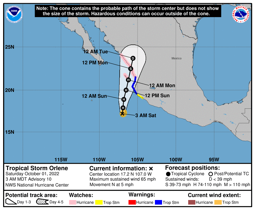
アメリカのナショナル・ハリケーンセンターによると、10月1日米国山岳部標準時(MDT)午前3時 (世界標準時午前9時) 、熱帯低気圧オーリーンの中心は北緯17.2度、西経107.0度付近にあって、時速約5マイル(7km/h)で北に向かって移動している。夜までに若干速いスピードで北北東方向に動き始め、来週初めにかけて同じ方向に進む予想だ。予想進路を見ると、オーリーンは月曜日にメキシコ本土の海岸に到達、上陸する見込みとなっている。
オーリーンは突風を伴い最大風速は約65mph(100km/h) 。日曜日までに着実に発達を続け、きょうの遅い時間にハリケーンになると予想されている。日曜日の夜になると勢力が次第に弱まってきそうだ。
強が風い範囲は中心から最大45マイル(75km)外側に広がっていて、中心気圧は994mb (29.36インチ) 。
■陸地への危険な影響
風:マリアス諸島では日曜日の夜はハリケーン級の暴風、その後、遅い時間帯まで熱帯低気圧級の暴風が吹く恐れがある。警戒区域では早い段階で影響が出てきそう。
警戒区域内にあるメキシコ本土の沿岸部は今夜と日曜日は熱帯低気圧級の暴風が吹く見込み。
雨:月曜日の夕方までに1時間に3~5インチの雨が降ると予想されている。メキシコ南西部の一部では10インチに達する恐れも。まとまった雨で鉄砲水が発生し、険しい地形の場所では地滑りが起こる可能性がある。かなり危険だ。
高潮:メキシコ沿岸でオンショアの風が予想される警戒エリアでは洪水の恐れがある。
波:オーリーンからの大きなうねりの影響は、今週末にかけて、メキシコ南西部沿岸およびバハ・カリフォルニア半島の最南端で出てきそう。うねりに伴い命に危険を及ぼすような高波とリップカレントが発生する恐れがある。詳しい情報は住んでいる地域の気象局に問い合わせを。
DISCUSSION AND OUTLOOK ———————-
At 300 AM MDT (0900 UTC), the center of Tropical Storm Orlene was located near latitude 17.2 North, longitude 107.0 West. Orlene is moving toward the north near 5 mph (7 km/h). A north-northeastward motion at a slightly faster speed is expected to begin by tonight and continue through early next week. On the forecast track, the center of Orlene should reach the coast of mainland Mexico on Monday.
Maximum sustained winds are near 65 mph (100 km/h) with higher gusts. Steady strengthening is expected through Sunday, and Orlene is forecast to become a hurricane later today. Steady weakening is expected to begin by Sunday night.
Tropical-storm-force winds extend outward up to 45 miles (75 km) from the center. The estimated minimum central pressure is 994 mb (29.36 inches).
HAZARDS AFFECTING LAND ———————-
WIND: Hurricane conditions are possible in Las Islas Marias Sunday night, with tropical storm conditions possible by late Sunday. Tropical storm conditions are expected in the warning area by early Sunday. Tropical storm conditions are possible along the coast of mainland Mexico within the tropical storm watch area tonight and Sunday.
RAINFALL: Into Monday evening, Orlene is expected to produce 3 to 5 inches of rainfall, with local amounts of 10 inches, for portions of Southwest Mexico. These rainfall amounts should lead to flash flooding, as well as possible landslides in areas of rugged terrain.
STORM SURGE: Coastal flooding is likely along the coast of Mexico in the warning area in regions of onshore winds.
SURF: Large swells generated by Orlene will affect the coast of southwestern Mexico, and the extreme southern portion of the Baja California peninsula through this weekend. These swells are likely to cause life-threatening surf and rip current conditions. Please consult products from your local weather office.
コメント