
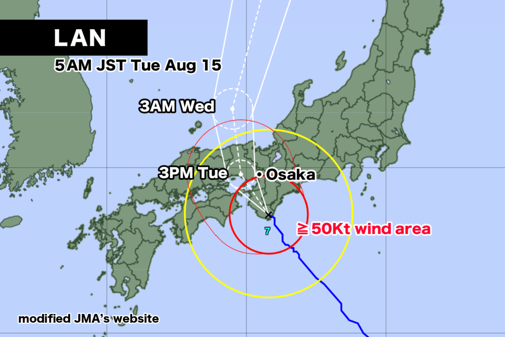
Typhoon LAN made landfall near Cape Shionomisaki in Wakayama Prefecture before 5 a.m., bringing with it gusts exceeding 25 m/s, as it continues to traverse the Kii Peninsula. As of 6 a.m., the central pressure is 975 hPa, with maximum sustained winds near the center reaching 30 m/s and maximum gusts of 45 m/s. The typhoon is moving at a relatively slow speed of 10 kilometers per hour northwestward.
The typhoon is expected to keep moving northward. If it follows the projected path, it is anticipated to reach the vicinity of Himeji City in Hyogo Prefecture by 3 p.m. today and eventually reach the Sea of Japan by late night.
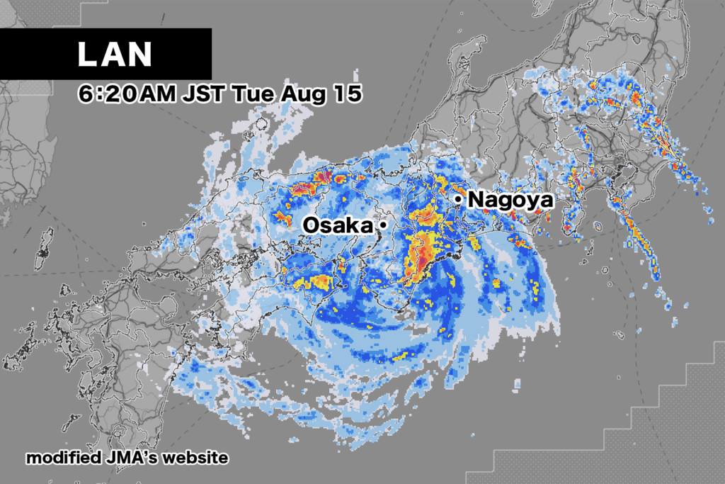
Currently, the rain clouds surrounding the typhoon have notably developed on the northeast side of its center. Kumano Atashika in Mie Prefecture recorded a 24-hour rainfall of 187 millimeters, setting a new record for August observations.
For the Kinki region, late tonight, the forecast predicts maximum hourly rainfall of up to 70 millimeters and maximum gusts of 45 m/s. The 24-hour rainfall until tomorrow morning could reach up to 300 millimeters in some areas. If a squall line forms, there’s a possibility of even higher rainfall.
Extreme caution is advised for strong winds, landslides, flooding in low-lying areas, rising river levels, flooding, and high tides.
【August 15, 5:15 AM, Japan Meteorological Agency Announcement】
Typhoon No. 7 is expected to move northward through the Kinki region on the 15th. In eastern and western Japan, extreme caution is advised for potential landslides, flooding in low-lying areas, rising river levels, flooding, and strong winds. Additionally, please exercise heightened vigilance against high waves, particularly in the Kinki region. Furthermore, in the Kinki and Tokai regions through the night of the 15th, Shikoku and Chugoku regions through the afternoon of the 15th, and Kanto-Koshin region during the morning of the 15th, there is a rapid increase in the risk of heavy rain disasters due to the formation of a squall line.
[Current Status and Forecast of the Typhoon]
As of 4 a.m. on the 15th, Typhoon No. 7 is located near Cape Shionomisaki, moving northwest at a speed of approximately 10 kilometers per hour. The central pressure is 975 hPa, maximum sustained winds are 30 meters per second, and maximum gusts are 45 meters per second. Winds of 25 meters per second or more are experienced within a radius of 130 kilometers from the center. The typhoon made landfall near Cape Shionomisaki before 5 a.m. on the 15th. Subsequently, the typhoon is projected to move northward through the Kinki region. The intensively developed rain clouds of the typhoon are situated slightly away from the center, implying the potential for violent winds and extremely heavy rainfall in areas apart from the center. Furthermore, the typhoon may advance northward over the Sea of Japan from the 16th to 17th, approaching the Hokkaido region.
[Disaster Preparedness]
<Heavy Rain, Thunder, and Gusts>
In eastern and western Japan, due to the inflow of moist air from around the typhoon, not only regions under the typhoon’s rain clouds but also areas distant from the typhoon will experience highly unstable atmospheric conditions. Therefore, heavy rainfall with thunder and extremely heavy rain is anticipated in western Japan on the 15th and in eastern Japan from the 16th. As the typhoon’s speed is slow, there is a possibility of total rainfall exceeding the average monthly precipitation for August.
Expected 24-hour rainfall until 6 a.m. on the 16th is as follows:
Tokai region: 350 mm
Kinki region: 300 mm
Chugoku region: 250 mm
Shikoku region, Hokuriku region, Kanto-Koshin region: 200 mm
If a squall line forms, localized areas could experience even greater rainfall. Remain vigilant against potential landslides, flooding in low-lying areas, and rising river levels or flooding. Additionally, pay attention to intense gusts such as lightning and tornadoes. If mature cumulonimbus clouds approach, ensure safety measures, such as moving indoors.<Violent Winds and High Waves> On the 15th, very strong to violent winds and stormy conditions are anticipated in eastern and western Japan.
Maximum wind speeds (maximum gust speeds) expected on the 15th are:
Kinki region, Tokai region: 30 meters per second (45 meters per second)
Shikoku region, Chugoku region: 25 meters per second (35 meters per second)
Hokuriku region: 23 meters per second (35 meters per second)
Anticipated wave heights on the 15th, accompanied by swells, are:
Kinki region: 8 meters
Tokai region: 7 meters
Shikoku region, Izu Islands: 6 meters
Exercise caution against swells in the Pacific Ocean side from eastern to western Japan.
<High Tide>
Due to the typhoon’s influence, there could be elevated tidal levels from the 16th in eastern and western Japan. In the Kinki region, remain on high alert for high tide occurrences.
コメント