

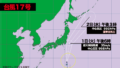
猛烈な勢力の台風18号は1日(火)午後9時現在、南シナ海をゆっくり北に進んでいる。台湾の南部が間もなく風速25メートル以上の暴風域に入る。台風は3日(木)に台湾に上陸し、4日(金)にかけて台湾を縦断する可能性が高い。
進行スピードが遅いため、台湾では雨風ともに強い状態が長く続き、甚大な被害が出る恐れがある。台風は5日(土)には東シナ海に進み、6日(日)に熱帯低気圧に変わる。
日本への影響は沖縄の八重山諸島や宮古諸島が風速15メートル以上の強風域に入る可能性があり、3日(水)以降、しばらく警報級の暴風、大雨、波浪に警戒が必要。
As of 9:00 p.m. on Tuesday, Typhoon No. 18, classified as a violent storm, is slowly moving northward over the South China Sea. Southern Taiwan is expected to enter the storm’s area of violent winds, with speeds exceeding 25 meters per second, in the near future. The typhoon is likely to make landfall in Taiwan on Thursday, the 3rd, and is expected to traverse the island through Friday, the 4th.
Due to its slow movement, Taiwan is likely to experience prolonged periods of heavy rain and strong winds, raising the risk of significant damage. The typhoon is projected to move into the East China Sea by Saturday, the 5th, and weaken into a tropical depression by Sunday, the 6th.
In Japan, the Yaeyama and Miyako Islands of Okinawa may enter the area of strong winds with speeds exceeding 15 meters per second. From Wednesday, the 3rd, onwards, there is a need for continued vigilance against potentially dangerous winds, heavy rain, and high waves, which could reach warning levels.

コメント