
・上陸する台風では歴代最強クラスに
・九州に上陸後、列島を縦断する恐れ
・動きが遅く影響が長引く可能性
・九州南部の総雨量は1000ミリにも
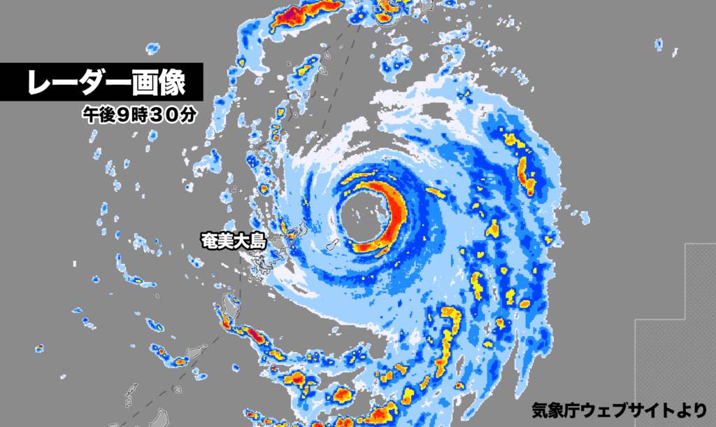
非常に強い勢力に発達した台風10号は、27日午後10時現在、鹿児島県奄美大島付近に停滞している。この台風の特徴は動きが遅く、そのため影響が長引く恐れがある。
レーダー画像では台風の目がはっきり確認でき、勢力が強い様子がうかがえる。現在は、台風の南側と東側にかなり発達した雨雲がある。
九州南部では台風の接近による総雨量が1000ミリに達する予想が出ていて、記録的な大雨になる可能性も。土砂災害、低地の浸水、川の増水や氾濫などに厳重な警戒が必要だ。

現在、台風の中心は奄美大島の東北東の海上にあり、動きがほとんど止まっている。
あす水曜日にはゆっくりと北に進み、鹿児島県十島村付近で勢力のピークを迎えそうだ。中心気圧は935ヘクトパスカルまで下がる見込みで、勢力をやや弱めながら北上。ただそれでも強い勢力を保って、木曜日の21時には熊本県天草市付近に達する予想だ。上陸時の勢力は過去最強クラスになる可能性がある。

台風はその後、東寄りに進路を変えて西日本を縦断、予報円の中心を進んだ場合、日曜日に関東地方に達する見込みだ。ただ土曜日と日曜日の予報円が大きく、進路が定まっていない。最も北のルートを進んだ場合は日本海、最も南のルートを進んだ場合は伊豆諸島を進む。
Typhoon No. 10, Now a Very Powerful Storm, Stalls Near Amami Oshima
As of 10:00 PM on the 27th, Typhoon No. 10, which has intensified into a very strong storm, remains stationary near Amami Oshima in Kagoshima Prefecture. A key characteristic of this typhoon is its slow movement, raising concerns that its impact could be prolonged.
Radar imagery distinctly shows the eye of the typhoon, underscoring its powerful intensity. Currently, heavily developed rain clouds are observed on the southern and eastern sides of the system.
In southern Kyushu, total rainfall due to the typhoon’s approach is expected to reach up to 1,000 millimeters, with the potential for record-breaking heavy rainfall. Authorities are urging strict caution against landslides, flooding in low-lying areas, and river surges or overflows.
The center of the typhoon is currently located over the waters northeast of Amami Oshima, with little movement observed. By tomorrow, Wednesday, the typhoon is expected to slowly progress northward, reaching its peak intensity near Toshima Village in Kagoshima Prefecture. The central pressure is forecasted to drop to 935 hPa as it moves northward, slightly weakening but still maintaining significant strength. By 9:00 PM on Thursday, it is projected to approach the vicinity of Amakusa City in Kumamoto Prefecture. The storm’s intensity at landfall could be among the strongest on record.
The typhoon is expected to shift its course eastward, crossing through western Japan. If it follows the center of the forecast track, it could reach the Kanto region by Sunday. However, the forecast cone for Saturday and Sunday is broad, indicating uncertainty in the typhoon’s path. Should it take the northernmost route, it could move into the Sea of Japan, while the southernmost route would see it passing through the Izu Islands.
コメント